![](/images/other/stat-length.png)
![Tocht Te voet Pievepelago - 20220725Passeggiata all'esterno - Photo](https://media.geolcdn.com/t/1900/400/ext.pjpeg?maxdim=2&url=https%3A%2F%2Fstatic1.geolcdn.com%2Fsiteimages%2Fupload%2Ffiles%2F1545311037marcheuse_200dpi.jpg)
20220725Passeggiata all'esterno
Maurizio Melandri
Gebruiker
![Lengte](/images/other/stat-length.png)
![Max. hoogte](https://static1.geolcdn.com/siteimages/upload/files/1508320355ic_sort_altitude_max_24dp.png)
![Positief hoogteverschil](https://static1.geolcdn.com/siteimages/upload/files/1508320355ic_sort_den_pos_24dp.png)
![Km-Effort](/images/other/stat-length.png)
![Min. hoogte](https://static1.geolcdn.com/siteimages/upload/files/1508320355ic_sort_altitude_min_24dp.png)
![Negatief hoogteverschil](https://static1.geolcdn.com/siteimages/upload/files/1508320355ic_sort_den_neg_24dp.png)
![Boucle](https://static1.geolcdn.com/siteimages/upload/files/16400158638029165_repeat_loop_refresh_sync_direction_icon.png)
![Te voet](https://static1.geolcdn.com/sitytour/trail-icons/100.png)
2h32
Moeilijkheid : Medium
![Scan deze QR-code om de tocht te openen in de SityTrail-applicatie](https://capi.geolives.com/qq0zvz2zws4bq2lad0pu/sitytour/trails/3337075/qr.png?size=200)
Gratisgps-wandelapplicatie
Over ons
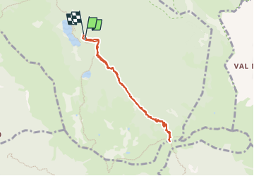
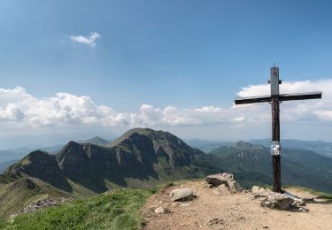
Tocht Te voet van 6,8 km beschikbaar op Emilia-Romagna, Modena, Pievepelago. Deze tocht wordt voorgesteld door Maurizio Melandri.
Beschrijving
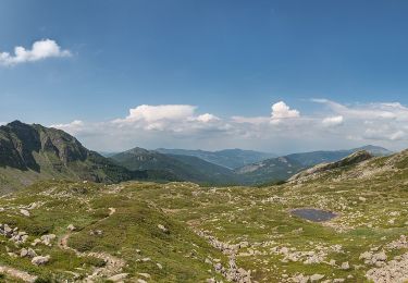
Dal parcheggio del lago Santo si prende il sentiero CAI 523 e lo si percorre fino al bivio con il 519
Si percorre il 519 fino alla Foce di Giovo
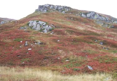
Unica difficoltà un passaggio su massi
Il dislivello positivo è praticamente tutto alla fine per raggiungere la Foce di Giovo
Plaatsbepaling
Opmerkingen
Wandeltochten in de omgeving
![Tocht Te voet Pievepelago - (SI L16) Lago Santo Modenese - Passo delle Radici - Photo](https://media.geolcdn.com/t/375/260/5e3e4a9c-3762-45fe-bacf-33e2f6ab55a3.jpeg&format=jpg&maxdim=2)
![Te voet Te voet](https://static1.geolcdn.com/sitytour/trail-icons/100.png)
Te voet
![](/images/other/stat-length.png)
![](https://static1.geolcdn.com/siteimages/upload/files/16400158638029165_repeat_loop_refresh_sync_direction_icon.png)
![Tocht Te voet Abetone Cutigliano - IT-507 - Photo](https://media.geolcdn.com/t/375/260/b0e1bc75-1c50-479c-ada2-a5db2babd61b.jpeg&format=jpg&maxdim=2)
![Te voet Te voet](https://static1.geolcdn.com/sitytour/trail-icons/100.png)
Te voet
![](/images/other/stat-length.png)
![](https://static1.geolcdn.com/siteimages/upload/files/16400158638029165_repeat_loop_refresh_sync_direction_icon.png)
![Tocht Te voet Pievepelago - (SI L16 OLD) Lago Santo Modenese - Passo delle Radici - Photo](https://media.geolcdn.com/t/375/260/5e3e4a9c-3762-45fe-bacf-33e2f6ab55a3.jpeg&format=jpg&maxdim=2)
![Te voet Te voet](https://static1.geolcdn.com/sitytour/trail-icons/100.png)
Te voet
![](/images/other/stat-length.png)
![](https://static1.geolcdn.com/siteimages/upload/files/16400158638029165_repeat_loop_refresh_sync_direction_icon.png)
![Tocht Te voet Fiumalbo - IT-505 - Photo](https://media.geolcdn.com/t/375/260/ba8edcd9-6d4d-4a3d-9510-b543506f2742.jpeg&format=jpg&maxdim=2)
![Te voet Te voet](https://static1.geolcdn.com/sitytour/trail-icons/100.png)
Te voet
![](/images/other/stat-length.png)
![](https://static1.geolcdn.com/siteimages/upload/files/16400158638029165_repeat_loop_refresh_sync_direction_icon.png)
![Tocht Te voet Abetone Cutigliano - IT-100 - Photo](https://media.geolcdn.com/t/375/260/555a5dd0-53d5-431c-8b7e-814ca8ca46c4.jpeg&format=jpg&maxdim=2)
![Te voet Te voet](https://static1.geolcdn.com/sitytour/trail-icons/100.png)
Te voet
![](/images/other/stat-length.png)
![](https://static1.geolcdn.com/siteimages/upload/files/16400158638029165_repeat_loop_refresh_sync_direction_icon.png)
![Tocht Te voet Abetone Cutigliano - Sentiero del Tedesco - Photo](https://media.geolcdn.com/t/375/260/ab8c7a67-de8b-49bd-88d7-f633522fd8d7.jpeg&format=jpg&maxdim=2)
![Te voet Te voet](https://static1.geolcdn.com/sitytour/trail-icons/100.png)
Te voet
![](/images/other/stat-length.png)
![](https://static1.geolcdn.com/siteimages/upload/files/16400158638029165_repeat_loop_refresh_sync_direction_icon.png)
![Tocht Te voet Barga - IT-26 - Photo](https://media.geolcdn.com/t/375/260/2ba31f33-202c-4b61-a077-f8278d72dc6a.jpeg&format=jpg&maxdim=2)
![Te voet Te voet](https://static1.geolcdn.com/sitytour/trail-icons/100.png)
![Tocht Te voet Abetone Cutigliano - IT-519 - Photo](https://media.geolcdn.com/t/375/260/d9c856e7-0fee-46cb-b1dc-d250ecd0b74b.jpeg&format=jpg&maxdim=2)
![Te voet Te voet](https://static1.geolcdn.com/sitytour/trail-icons/100.png)
Te voet
![](/images/other/stat-length.png)
![](https://static1.geolcdn.com/siteimages/upload/files/16400158638029165_repeat_loop_refresh_sync_direction_icon.png)
![Tocht Te voet Pievepelago - IT-517 - Photo](https://media.geolcdn.com/t/375/260/f32fbdf8-e41e-4738-9caa-14faec4dc6b0.jpeg&format=jpg&maxdim=2)
![Te voet Te voet](https://static1.geolcdn.com/sitytour/trail-icons/100.png)
Te voet
![](/images/other/stat-length.png)
![](https://static1.geolcdn.com/siteimages/upload/files/16400158638029165_repeat_loop_refresh_sync_direction_icon.png)