![](/images/other/stat-length.png)
![Tocht Elektrische fiets Sainte-Marie-aux-Mines - VTT - Creux Chêne - Col de la Hingrie - Chaume de Lusse - Photo](https://media.geolcdn.com/t/1900/400/ext.pjpeg?maxdim=2&url=https%3A%2F%2Fstatic1.geolcdn.com%2Fsiteimages%2Fupload%2Ffiles%2F1524743154velo.jpg)
VTT - Creux Chêne - Col de la Hingrie - Chaume de Lusse
patandre
Gebruiker
![Lengte](/images/other/stat-length.png)
Lengte
35 km
![Max. hoogte](https://static1.geolcdn.com/siteimages/upload/files/1508320355ic_sort_altitude_max_24dp.png)
Max. hoogte
891 m
![Positief hoogteverschil](https://static1.geolcdn.com/siteimages/upload/files/1508320355ic_sort_den_pos_24dp.png)
Positief hoogteverschil
811 m
![Km-Effort](/images/other/stat-length.png)
Km-Effort
46 km
![Min. hoogte](https://static1.geolcdn.com/siteimages/upload/files/1508320355ic_sort_altitude_min_24dp.png)
Min. hoogte
269 m
![Negatief hoogteverschil](https://static1.geolcdn.com/siteimages/upload/files/1508320355ic_sort_den_neg_24dp.png)
Negatief hoogteverschil
815 m
![Boucle](https://static1.geolcdn.com/siteimages/upload/files/16400158638029165_repeat_loop_refresh_sync_direction_icon.png)
Boucle
Ja
Datum van aanmaak :
2022-07-30 05:36:28.459
Laatste wijziging :
2022-07-30 12:45:27.445
![Elektrische fiets](https://static1.geolcdn.com/sitytour/trail-icons/205.png)
3h00
Moeilijkheid : Medium
![Scan deze QR-code om de tocht te openen in de SityTrail-applicatie](https://capi.geolives.com/qq0zvz2zws4bq2lad0pu/sitytour/trails/3334808/qr.png?size=200)
Gratisgps-wandelapplicatie
Over ons
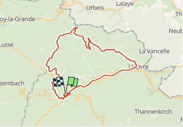
Tocht Elektrische fiets van 35 km beschikbaar op Grand Est, Haut-Rhin, Sainte-Marie-aux-Mines. Deze tocht wordt voorgesteld door patandre.
Beschrijving
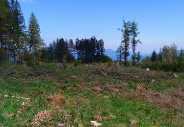
Départ de Ste Marie aux Mines, piste cyclable jusqu'à Lièpvre, Rombach le Franc, Route de la Hingrie, Creux Chêne, Col de la Hingrie, col de Ralaine, Grand Sterpois, Chaume de Lusse, et retour sur Ste Marie aux Mines par le Fenarupt
Plaatsbepaling
Land:
France
Regio :
Grand Est
Departement/Provincie :
Haut-Rhin
Gemeente :
Sainte-Marie-aux-Mines
Locatie:
Unknown
Vertrek:(Dec)
Vertrek:(UTM)
365265 ; 5345546 (32U) N.
Opmerkingen
Wandeltochten in de omgeving
![Tocht Stappen Sainte-Marie-aux-Mines - 2020-06-20 Marche Tete du Violu Col de Ste Marie - Photo](https://media.geolcdn.com/t/375/260/d44ae4f7-8944-4d5a-a40f-b5db5e1cd846.jpg&format=jpg&maxdim=2)
![Stappen Stappen](https://static1.geolcdn.com/sitytour/trail-icons/101.png)
2020-06-20 Marche Tete du Violu Col de Ste Marie
Stappen
Heel gemakkelijk
Sainte-Marie-aux-Mines,
Grand Est,
Haut-Rhin,
France
![](/images/other/stat-length.png)
14,1 km | 21 km-effort
4h 14min
![](https://static1.geolcdn.com/siteimages/upload/files/16400158638029165_repeat_loop_refresh_sync_direction_icon.png)
Ja
![Tocht Stappen Sainte-Marie-aux-Mines - la croix de Ribeauvillé - Photo](https://media.geolcdn.com/t/375/260/d5b1ea95-9e8b-4e75-bd59-dd918afbb44b.jpg&format=jpg&maxdim=2)
![Stappen Stappen](https://static1.geolcdn.com/sitytour/trail-icons/101.png)
la croix de Ribeauvillé
Stappen
Medium
Sainte-Marie-aux-Mines,
Grand Est,
Haut-Rhin,
France
![](/images/other/stat-length.png)
12,5 km | 18,1 km-effort
6h 2min
![](https://static1.geolcdn.com/siteimages/upload/files/16400158638029165_repeat_loop_refresh_sync_direction_icon.png)
Ja
![Tocht Stappen Sainte-Marie-aux-Mines - taenichel - Photo](https://media.geolcdn.com/t/375/260/f89cec21-9478-4217-bf8a-15cadae40096.jpg&format=jpg&maxdim=2)
![Stappen Stappen](https://static1.geolcdn.com/sitytour/trail-icons/101.png)
taenichel
Stappen
Medium
Sainte-Marie-aux-Mines,
Grand Est,
Haut-Rhin,
France
![](/images/other/stat-length.png)
13,3 km | 19,1 km-effort
5h 26min
![](https://static1.geolcdn.com/siteimages/upload/files/16400158638029165_repeat_loop_refresh_sync_direction_icon.png)
Ja
![Tocht Stappen Sainte-Marie-aux-Mines - Col du Haut de Ribeauvillé - Rochers des Géants (Rother n°31) - Photo](https://media.geolcdn.com/t/375/260/cfbc15a6-3f32-42dc-813b-8bce71fe94c9.jpg&format=jpg&maxdim=2)
![Stappen Stappen](https://static1.geolcdn.com/sitytour/trail-icons/101.png)
Col du Haut de Ribeauvillé - Rochers des Géants (Rother n°31)
Stappen
Medium
Sainte-Marie-aux-Mines,
Grand Est,
Haut-Rhin,
France
![](/images/other/stat-length.png)
15,3 km | 22 km-effort
3h 56min
![](https://static1.geolcdn.com/siteimages/upload/files/16400158638029165_repeat_loop_refresh_sync_direction_icon.png)
Ja
![Tocht Stappen Sainte-Marie-aux-Mines - rocher des chèvred - Photo](https://media.geolcdn.com/t/375/260/1ee03ea7-dcc4-4aab-8946-92ada103a5f7.jpg&format=jpg&maxdim=2)
![Stappen Stappen](https://static1.geolcdn.com/sitytour/trail-icons/101.png)
rocher des chèvred
Stappen
Moeilijk
(2)
Sainte-Marie-aux-Mines,
Grand Est,
Haut-Rhin,
France
![](/images/other/stat-length.png)
8,9 km | 13,3 km-effort
2h 40min
![](https://static1.geolcdn.com/siteimages/upload/files/16400158638029165_repeat_loop_refresh_sync_direction_icon.png)
Ja
![Tocht Stappen Gemaingoutte - col Sainte Marie aux mines - Photo](https://media.geolcdn.com/t/375/260/644b77d8-a894-4e68-a040-8ae35dcbcebd.jpg&format=jpg&maxdim=2)
![Stappen Stappen](https://static1.geolcdn.com/sitytour/trail-icons/101.png)
col Sainte Marie aux mines
Stappen
Zeer moeilijk
Gemaingoutte,
Grand Est,
Vogezen,
France
![](/images/other/stat-length.png)
14,5 km | 22 km-effort
4h 20min
![](https://static1.geolcdn.com/siteimages/upload/files/16400158638029165_repeat_loop_refresh_sync_direction_icon.png)
Ja
![Tocht Stappen Sainte-Marie-aux-Mines - Crête granitique et forêts profondes - Photo](https://media.geolcdn.com/t/375/260/cdc1fd69-bfc3-4d29-b7a2-7dbb2d83ce85.jpg&format=jpg&maxdim=2)
![Stappen Stappen](https://static1.geolcdn.com/sitytour/trail-icons/101.png)
Crête granitique et forêts profondes
Stappen
Medium
Sainte-Marie-aux-Mines,
Grand Est,
Haut-Rhin,
France
![](/images/other/stat-length.png)
13,7 km | 22 km-effort
3h 56min
![](https://static1.geolcdn.com/siteimages/upload/files/16400158638029165_repeat_loop_refresh_sync_direction_icon.png)
Ja
![Tocht Stappen Sainte-Marie-aux-Mines - Col de Ste Marie aux Mines (27/8/2020) - Photo](https://media.geolcdn.com/t/375/260/3833d58d-a4ad-4457-8aab-f5dc83ae5397.jpg&format=jpg&maxdim=2)
![Stappen Stappen](https://static1.geolcdn.com/sitytour/trail-icons/101.png)
Col de Ste Marie aux Mines (27/8/2020)
Stappen
Medium
Sainte-Marie-aux-Mines,
Grand Est,
Haut-Rhin,
France
![](/images/other/stat-length.png)
18,3 km | 29 km-effort
5h 4min
![](https://static1.geolcdn.com/siteimages/upload/files/16400158638029165_repeat_loop_refresh_sync_direction_icon.png)
Ja
![Tocht Noords wandelen Sainte-Marie-aux-Mines - col Ste Marie aux Mines / Point de vue Soremont / Tête du Violu - Photo](https://media.geolcdn.com/t/375/260/f65167e5-c50f-498a-8875-a70e49e5d697.jpg&format=jpg&maxdim=2)
![Noords wandelen Noords wandelen](https://static1.geolcdn.com/sitytour/trail-icons/102.png)
col Ste Marie aux Mines / Point de vue Soremont / Tête du Violu
Noords wandelen
Medium
Sainte-Marie-aux-Mines,
Grand Est,
Haut-Rhin,
France
![](/images/other/stat-length.png)
14,4 km | 21 km-effort
3h 23min
![](https://static1.geolcdn.com/siteimages/upload/files/16400158638029165_repeat_loop_refresh_sync_direction_icon.png)
Ja