![](/images/other/stat-length.png)
![Tocht Sneeuwschoenen La Llagonne - tour des lacs - Photo](https://media.geolcdn.com/t/1900/400/ext.pjpeg?maxdim=2&url=https%3A%2F%2Fservices.sitytrail.com%2FGeolivesWS%2FDownloadMedia.ashx%3FTrailID%3D333312%26Media%3Dfix__20140209141946.jpg)
tour des lacs
PVERTICAL
Gebruiker
![Lengte](/images/other/stat-length.png)
Lengte
17,2 km
![Max. hoogte](https://static1.geolcdn.com/siteimages/upload/files/1508320355ic_sort_altitude_max_24dp.png)
Max. hoogte
2245 m
![Positief hoogteverschil](https://static1.geolcdn.com/siteimages/upload/files/1508320355ic_sort_den_pos_24dp.png)
Positief hoogteverschil
645 m
![Km-Effort](/images/other/stat-length.png)
Km-Effort
26 km
![Min. hoogte](https://static1.geolcdn.com/siteimages/upload/files/1508320355ic_sort_altitude_min_24dp.png)
Min. hoogte
1727 m
![Negatief hoogteverschil](https://static1.geolcdn.com/siteimages/upload/files/1508320355ic_sort_den_neg_24dp.png)
Negatief hoogteverschil
644 m
![Boucle](https://static1.geolcdn.com/siteimages/upload/files/16400158638029165_repeat_loop_refresh_sync_direction_icon.png)
Boucle
Ja
Datum van aanmaak :
2014-12-10 00:00:00.0
Laatste wijziging :
2014-12-10 00:00:00.0
![Sneeuwschoenen](https://static1.geolcdn.com/sitytour/trail-icons/504.png)
5h52
Moeilijkheid : Moeilijk
![Scan deze QR-code om de tocht te openen in de SityTrail-applicatie](https://capi.geolives.com/qq0zvz2zws4bq2lad0pu/sitytour/trails/333312/qr.png?size=200)
Gratisgps-wandelapplicatie
Over ons
Tocht Sneeuwschoenen van 17,2 km beschikbaar op Occitanië, Pyrénées-Orientales, La Llagonne. Deze tocht wordt voorgesteld door PVERTICAL.
Beschrijving
par les Bouillouses - ATTENTION : Prendre toutes précautions avant de traverser les lacs gelés, en cas de doute ne pas hésiter à privilégier les bords
Plaatsbepaling
Land:
France
Regio :
Occitanië
Departement/Provincie :
Pyrénées-Orientales
Gemeente :
La Llagonne
Locatie:
Unknown
Vertrek:(Dec)
Vertrek:(UTM)
421216 ; 4710883 (31T) N.
Opmerkingen
Wandeltochten in de omgeving
![Tocht Stappen Font-Romeu-Odeillo-Via - Coll del Pam lac des Bouillouses - Photo](https://media.geolcdn.com/t/375/260/ext.jpg?maxdim=2&url=https%3A%2F%2Fservices.sitytrail.com%2FGeolivesWS%2FDownloadMedia.ashx%3FTrailID%3D802013%26Media%3Dfix__20170803141713.jpg)
![Stappen Stappen](https://static1.geolcdn.com/sitytour/trail-icons/101.png)
Coll del Pam lac des Bouillouses
Stappen
Medium
(2)
Font-Romeu-Odeillo-Via,
Occitanië,
Pyrénées-Orientales,
France
![](/images/other/stat-length.png)
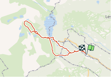
13,3 km | 19,3 km-effort
4h 10min
![](https://static1.geolcdn.com/siteimages/upload/files/16400158638029165_repeat_loop_refresh_sync_direction_icon.png)
Ja
![Tocht Sneeuwschoenen Font-Romeu-Odeillo-Via - pic dels moros - Photo](https://media.geolcdn.com/t/375/260/ext.jpg?maxdim=2&url=https%3A%2F%2Fservices.sitytrail.com%2FGeolivesWS%2FDownloadMedia.ashx%3FTrailID%3D509986%26Media%3Dfix__20140323122816.jpg)
![Sneeuwschoenen Sneeuwschoenen](https://static1.geolcdn.com/sitytour/trail-icons/504.png)
pic dels moros
Sneeuwschoenen
Medium
(1)
Font-Romeu-Odeillo-Via,
Occitanië,
Pyrénées-Orientales,
France
![](/images/other/stat-length.png)
12,6 km | 19,4 km-effort
4h 46min
![](https://static1.geolcdn.com/siteimages/upload/files/16400158638029165_repeat_loop_refresh_sync_direction_icon.png)
Ja
![Tocht Sneeuwschoenen Les Angles - Lac d Aude -Refuge Bernardi les Angles - Photo](https://media.geolcdn.com/t/375/260/ext.jpg?maxdim=2&url=https%3A%2F%2Fservices.sitytrail.com%2FGeolivesWS%2FDownloadMedia.ashx%3FTrailID%3D400729%26Media%3Dfix__20150327134406.jpg)
![Sneeuwschoenen Sneeuwschoenen](https://static1.geolcdn.com/sitytour/trail-icons/504.png)
Lac d Aude -Refuge Bernardi les Angles
Sneeuwschoenen
Medium
(1)
Les Angles,
Occitanië,
Pyrénées-Orientales,
France
![](/images/other/stat-length.png)
13,9 km | 19,1 km-effort
5h 44min
![](https://static1.geolcdn.com/siteimages/upload/files/16400158638029165_repeat_loop_refresh_sync_direction_icon.png)
Ja
![Tocht Stappen Les Angles - le tour des lacs de carli - Photo](https://media.geolcdn.com/t/375/260/ext.jpg?maxdim=2&url=https%3A%2F%2Fservices.sitytrail.com%2FGeolivesWS%2FDownloadMedia.ashx%3FTrailID%3D205430%26Media%3Dfix__20130716110753.jpg)
![Stappen Stappen](https://static1.geolcdn.com/sitytour/trail-icons/101.png)
le tour des lacs de carli
Stappen
Medium
(2)
Les Angles,
Occitanië,
Pyrénées-Orientales,
France
![](/images/other/stat-length.png)
11,4 km | 16,6 km-effort
3h 51min
![](https://static1.geolcdn.com/siteimages/upload/files/16400158638029165_repeat_loop_refresh_sync_direction_icon.png)
Neen
![Tocht Stappen Les Angles - Rando des 12 lacs - Photo](https://media.geolcdn.com/t/375/260/ext.jpg?maxdim=2&url=https%3A%2F%2Fservices.sitytrail.com%2FGeolivesWS%2FDownloadMedia.ashx%3FTrailID%3D136989%26Media%3D20120701094842.jpg)
![Stappen Stappen](https://static1.geolcdn.com/sitytour/trail-icons/101.png)
Rando des 12 lacs
Stappen
Gemakkelijk
(1)
Les Angles,
Occitanië,
Pyrénées-Orientales,
France
![](/images/other/stat-length.png)
14,1 km | 20 km-effort
6h 30min
![](https://static1.geolcdn.com/siteimages/upload/files/16400158638029165_repeat_loop_refresh_sync_direction_icon.png)
Ja
![Tocht Sneeuwschoenen Font-Romeu-Odeillo-Via - Pic dels Moros avec Pierre - Photo](https://media.geolcdn.com/t/375/260/ext.jpg?maxdim=2&url=https%3A%2F%2Fservices.sitytrail.com%2FGeolivesWS%2FDownloadMedia.ashx%3FTrailID%3D542171%26Media%3Dfix__20160322124727.jpg)
![Sneeuwschoenen Sneeuwschoenen](https://static1.geolcdn.com/sitytour/trail-icons/504.png)
Pic dels Moros avec Pierre
Sneeuwschoenen
Medium
(1)
Font-Romeu-Odeillo-Via,
Occitanië,
Pyrénées-Orientales,
France
![](/images/other/stat-length.png)
10,5 km | 15,9 km-effort
4h 4min
![](https://static1.geolcdn.com/siteimages/upload/files/16400158638029165_repeat_loop_refresh_sync_direction_icon.png)
Ja
![Tocht Stappen Égat - Egat Puig Moro - Photo](https://media.geolcdn.com/t/375/260/ext.jpg?maxdim=2&url=https%3A%2F%2Fservices.sitytrail.com%2FGeolivesWS%2FDownloadMedia.ashx%3FTrailID%3D460362%26Media%3Dfix__20150817141649.jpg)
![Stappen Stappen](https://static1.geolcdn.com/sitytour/trail-icons/101.png)
Egat Puig Moro
Stappen
Medium
(1)
Égat,
Occitanië,
Pyrénées-Orientales,
France
![](/images/other/stat-length.png)
13,4 km | 19,3 km-effort
4h 51min
![](https://static1.geolcdn.com/siteimages/upload/files/16400158638029165_repeat_loop_refresh_sync_direction_icon.png)
Ja
![Tocht Stappen Égat - La croix d'Egat - Photo](https://media.geolcdn.com/t/375/260/ext.jpg?maxdim=2&url=https%3A%2F%2Fservices.sitytrail.com%2FGeolivesWS%2FDownloadMedia.ashx%3FTrailID%3D143230%26Media%3D20120803102022.jpeg)
![Stappen Stappen](https://static1.geolcdn.com/sitytour/trail-icons/101.png)
La croix d'Egat
Stappen
Gemakkelijk
(1)
Égat,
Occitanië,
Pyrénées-Orientales,
France
![](/images/other/stat-length.png)
7,1 km | 10,4 km-effort
2h 2min
![](https://static1.geolcdn.com/siteimages/upload/files/16400158638029165_repeat_loop_refresh_sync_direction_icon.png)
Ja
![Tocht Stappen Égat - Le Pic dels Moros - Photo](https://media.geolcdn.com/t/375/260/ext.jpg?maxdim=2&url=https%3A%2F%2Fservices.sitytrail.com%2FGeolivesWS%2FDownloadMedia.ashx%3FTrailID%3D108942%26Media%3D2804_1.jpg)
![Stappen Stappen](https://static1.geolcdn.com/sitytour/trail-icons/101.png)
Le Pic dels Moros
Stappen
Moeilijk
(2)
Égat,
Occitanië,
Pyrénées-Orientales,
France
![](/images/other/stat-length.png)
12,1 km | 18,8 km-effort
5h 30min
![](https://static1.geolcdn.com/siteimages/upload/files/16400158638029165_repeat_loop_refresh_sync_direction_icon.png)
Ja