Tocht Paardrijden Saint-Riquier - Equirando jour 3 - Photo
 jcvmax
jcvmax

Gebruiker

© OpenStreetMap contributors
Lengte
Lengte
29 km
Max. hoogte
Max. hoogte
92 m
Positief hoogteverschil
429 m
Km-Effort
Km-Effort  
35 km
Min. hoogte
Min. hoogte
20 m
Negatief hoogteverschil
391 m
Boucle
Boucle
Neen
Datum van aanmaak :
2022-07-28 07:44:26.0
Laatste wijziging :
2022-07-28 14:24:21.02

(0 Bericht)

Paardrijden
Paardrijden
5h45
Moeilijkheid : Moeilijk

Scan deze QR-code om de tocht te openen in de SityTrail-applicatie

Gratisgps-wandelapplicatie

Logo SityTrail SityTrail

IGN / Geografische instituten

SityTrail uit de App Store downloaden SityTrail uit Google Play downloaden

Logo SityTrail SityTrail World

De wereld gaat voor u open

SityTrail uit de App Store downloaden SityTrail uit Google Play downloaden SityTrail op Huawei AppGallery downloaden

Over ons

Tocht Paardrijden van 29 km beschikbaar op Hauts-de-France, Somme, Saint-Riquier. Deze tocht wordt voorgesteld door jcvmax.

Hoogteprofiel

Plaatsbepaling

Land:
France
Regio :
Hauts-de-France
Departement/Provincie :
Somme
Gemeente :
Saint-Riquier
Locatie:
Unknown
Vertrek:(Dec)
Vertrek:(UTM)
425439 ; 5553995 (31U) N.

Wandeltochten in de omgeving

Tocht Te voet Saint-Riquier - Balade Centuloise - Photo
Te voet
GUIDE+

Te voet

Gemakkelijk
Saint-Riquier, Hauts-de-France, Somme, France
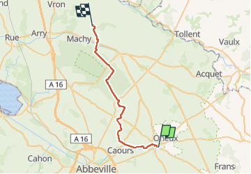
8,9 km | 10,3 km-effort
2h 20min
Ja
Tocht Stappen Millencourt-en-Ponthieu - le fond de Millencourt - Photo
Stappen
Luc Gengoux

Stappen

Heel gemakkelijk
Millencourt-en-Ponthieu, Hauts-de-France, Somme, France
7 km | 8,2 km-effort
2h 2min
Ja
Tocht Noords wandelen Saint-Riquier - La Centuloise 2023 - Photo
Noords wandelen
roselinemazeyrat

Noords wandelen

Saint-Riquier, Hauts-de-France, Somme, France
13,9 km | 16,2 km-effort
2h 50min
Ja
Tocht Stappen Saint-Riquier - St riquier-maison roland  - Photo
Stappen
docfil

Stappen

Heel gemakkelijk
Saint-Riquier, Hauts-de-France, Somme, France
10,4 km | 11,9 km-effort
2h 3min
Ja
Tocht Andere activiteiten Vauchelles-les-Quesnoy - 1ère étape SOMME  - Photo
Andere activiteiten
c.p1970

Andere activiteiten

Heel gemakkelijk
Vauchelles-les-Quesnoy, Hauts-de-France, Somme, France
22 km | 24 km-effort
6h 21min
Neen
Tocht Stappen Oneux - Le fond d'Oneux - Photo
Stappen
tracegps

Stappen

Moeilijk
Oneux, Hauts-de-France, Somme, France
9,4 km | 11 km-effort
3h 0min
Ja
Tocht Stappen Millencourt-en-Ponthieu - Le fond de Millencourt - Photo
Stappen
tracegps

Stappen

Medium
(1)
Millencourt-en-Ponthieu, Hauts-de-France, Somme, France
6,9 km | 8,1 km-effort
2h 19min
Ja
Tocht Stappen Saint-Riquier - Balade centuloise - Photo
Stappen
tracegps

Stappen

Moeilijk
Saint-Riquier, Hauts-de-France, Somme, France
8,9 km | 10,4 km-effort
3h 0min
Ja
Tocht Stappen Saint-Riquier - La traverse du Ponthieu (Saint-Riquier Conteville) - Photo
Stappen
tracegps

Stappen

Moeilijk
Saint-Riquier, Hauts-de-France, Somme, France
10,7 km | 12,3 km-effort
3h 30min
Neen


Sluiten
Mijn abonnementen