![](/images/other/stat-length.png)
![Tocht Stappen Valtournenche - crepin, val dAoste 7a - Photo](https://media.geolcdn.com/t/1900/400/ext.pjpeg?maxdim=2&url=https%3A%2F%2Fstatic1.geolcdn.com%2Fsiteimages%2Fupload%2Ffiles%2F1553511878bg_sport_marche.png)
crepin, val dAoste 7a
David Toussaint
Gebruiker
![Lengte](/images/other/stat-length.png)
Lengte
5,2 km
![Max. hoogte](https://static1.geolcdn.com/siteimages/upload/files/1508320355ic_sort_altitude_max_24dp.png)
Max. hoogte
1765 m
![Positief hoogteverschil](https://static1.geolcdn.com/siteimages/upload/files/1508320355ic_sort_den_pos_24dp.png)
Positief hoogteverschil
205 m
![Km-Effort](/images/other/stat-length.png)
Km-Effort
8 km
![Min. hoogte](https://static1.geolcdn.com/siteimages/upload/files/1508320355ic_sort_altitude_min_24dp.png)
Min. hoogte
1587 m
![Negatief hoogteverschil](https://static1.geolcdn.com/siteimages/upload/files/1508320355ic_sort_den_neg_24dp.png)
Negatief hoogteverschil
206 m
![Boucle](https://static1.geolcdn.com/siteimages/upload/files/16400158638029165_repeat_loop_refresh_sync_direction_icon.png)
Boucle
Ja
Datum van aanmaak :
2022-07-23 14:40:12.193
Laatste wijziging :
2022-07-23 17:02:41.777
![Stappen](https://static1.geolcdn.com/sitytour/trail-icons/101.png)
2h00
Moeilijkheid : Medium
![Scan deze QR-code om de tocht te openen in de SityTrail-applicatie](https://capi.geolives.com/qq0zvz2zws4bq2lad0pu/sitytour/trails/3326592/qr.png?size=200)
Gratisgps-wandelapplicatie
Over ons
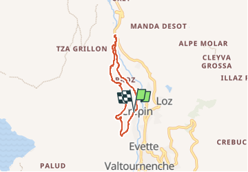
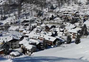
Tocht Stappen van 5,2 km beschikbaar op Valle d'Aosta, Onbekend, Valtournenche. Deze tocht wordt voorgesteld door David Toussaint.
Beschrijving
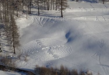
Belle rando depuis le village de Crepin jusqu'aux gorges du RÛ.
Combinaison des balisages 1 et 7A, très bien fléchés par ailleurs.
Plaatsbepaling
Land:
Italy
Regio :
Valle d'Aosta
Departement/Provincie :
Onbekend
Gemeente :
Valtournenche
Locatie:
Unknown
Vertrek:(Dec)
Vertrek:(UTM)
393037 ; 5082373 (32T) N.
Opmerkingen
Wandeltochten in de omgeving
![Tocht Te voet Valtournenche - Alta Via n. 1 della Valle d'Aosta - Tappa 10 - Photo](https://media.geolcdn.com/t/375/260/2d4a362f-5aa1-417e-8a6b-be0439474bd6.jpeg&format=jpg&maxdim=2)
![Te voet Te voet](https://static1.geolcdn.com/sitytour/trail-icons/100.png)
Alta Via n. 1 della Valle d'Aosta - Tappa 10
Te voet
Moeilijk
Valtournenche,
Valle d'Aosta,
Onbekend,
Italy
![](/images/other/stat-length.png)
16,1 km | 33 km-effort
7h 24min
![](https://static1.geolcdn.com/siteimages/upload/files/16400158638029165_repeat_loop_refresh_sync_direction_icon.png)
Neen
![Tocht Te voet Valtournenche - Alta Via n. 1 della Valle d'Aosta - Tappa 9 - Photo](https://media.geolcdn.com/t/375/260/224941b8-ec0f-4546-9f0d-eac73fc99d3b.jpeg&format=jpg&maxdim=2)
![Te voet Te voet](https://static1.geolcdn.com/sitytour/trail-icons/100.png)
Alta Via n. 1 della Valle d'Aosta - Tappa 9
Te voet
Gemakkelijk
Valtournenche,
Valle d'Aosta,
Onbekend,
Italy
![](/images/other/stat-length.png)
4,5 km | 11,2 km-effort
2h 32min
![](https://static1.geolcdn.com/siteimages/upload/files/16400158638029165_repeat_loop_refresh_sync_direction_icon.png)
Neen
![Tocht Te voet Valtournenche - (SI F17) Valtournenche - Rifugio Grand Tournalin - Photo](https://media.geolcdn.com/t/375/260/c89ae013-b1cb-419e-9d5e-2afa09d90d27.jpeg&format=jpg&maxdim=2)
![Te voet Te voet](https://static1.geolcdn.com/sitytour/trail-icons/100.png)
(SI F17) Valtournenche - Rifugio Grand Tournalin
Te voet
Medium
Valtournenche,
Valle d'Aosta,
Onbekend,
Italy
![](/images/other/stat-length.png)
8,7 km | 23 km-effort
5h 13min
![](https://static1.geolcdn.com/siteimages/upload/files/16400158638029165_repeat_loop_refresh_sync_direction_icon.png)
Neen
![Tocht Te voet Valtournenche - (SI F16) Rifugio Barmasse - Valtournenche - Photo](https://media.geolcdn.com/t/375/260/231fe912-1f0a-4aab-8b08-e45916d0a197.jpeg&format=jpg&maxdim=2)
![Te voet Te voet](https://static1.geolcdn.com/sitytour/trail-icons/100.png)
(SI F16) Rifugio Barmasse - Valtournenche
Te voet
Gemakkelijk
Valtournenche,
Valle d'Aosta,
Onbekend,
Italy
![](/images/other/stat-length.png)
4,6 km | 7 km-effort
1h 34min
![](https://static1.geolcdn.com/siteimages/upload/files/16400158638029165_repeat_loop_refresh_sync_direction_icon.png)
Neen
![Tocht Te voet Ayas - Itinerario 4 Chamois Corgnolaz Colle Nannaz - Photo](https://media.geolcdn.com/t/375/260/51ad9c66-d8b6-4d6b-8376-6ce56c218a93.jpeg&format=jpg&maxdim=2)
![Te voet Te voet](https://static1.geolcdn.com/sitytour/trail-icons/100.png)
Itinerario 4 Chamois Corgnolaz Colle Nannaz
Te voet
Gemakkelijk
Ayas,
Valle d'Aosta,
Onbekend,
Italy
![](/images/other/stat-length.png)
6,7 km | 9,9 km-effort
2h 15min
![](https://static1.geolcdn.com/siteimages/upload/files/16400158638029165_repeat_loop_refresh_sync_direction_icon.png)
Neen
![Tocht Te voet Ayas - Itinerario 3 Chamois Col di Nannaz - Photo](https://media.geolcdn.com/t/375/260/51ad9c66-d8b6-4d6b-8376-6ce56c218a93.jpeg&format=jpg&maxdim=2)
![Te voet Te voet](https://static1.geolcdn.com/sitytour/trail-icons/100.png)
Itinerario 3 Chamois Col di Nannaz
Te voet
Gemakkelijk
Ayas,
Valle d'Aosta,
Onbekend,
Italy
![](/images/other/stat-length.png)
7,2 km | 10,7 km-effort
2h 26min
![](https://static1.geolcdn.com/siteimages/upload/files/16400158638029165_repeat_loop_refresh_sync_direction_icon.png)
Neen
![Tocht Te voet Torgnon - Gran Balconata del Cervino - Photo](https://media.geolcdn.com/t/375/260/a69bc1c0-4ec5-402c-b107-c41e1d136f1d.jpeg&format=jpg&maxdim=2)
![Te voet Te voet](https://static1.geolcdn.com/sitytour/trail-icons/100.png)
Gran Balconata del Cervino
Te voet
Medium
Torgnon,
Valle d'Aosta,
Onbekend,
Italy
![](/images/other/stat-length.png)
17,7 km | 30 km-effort
6h 45min
![](https://static1.geolcdn.com/siteimages/upload/files/16400158638029165_repeat_loop_refresh_sync_direction_icon.png)
Neen
![Tocht Te voet Ayas - Itinerario 3A Ru Cleva Bella - Photo](https://media.geolcdn.com/t/375/260/a6a4ee1d-f988-4860-928f-d2008b5c46bb.jpeg&format=jpg&maxdim=2)
![Te voet Te voet](https://static1.geolcdn.com/sitytour/trail-icons/100.png)
Itinerario 3A Ru Cleva Bella
Te voet
Gemakkelijk
Ayas,
Valle d'Aosta,
Onbekend,
Italy
![](/images/other/stat-length.png)
4,8 km | 6,7 km-effort
1h 31min
![](https://static1.geolcdn.com/siteimages/upload/files/16400158638029165_repeat_loop_refresh_sync_direction_icon.png)
Neen
![Tocht Te voet Valtournenche - Itinerario n. 2 Moulin Cortina - Photo](https://media.geolcdn.com/t/375/260/2c40cf55-6b92-499f-ad6c-4c7e582acd07.jpeg&format=jpg&maxdim=2)
![Te voet Te voet](https://static1.geolcdn.com/sitytour/trail-icons/100.png)
Itinerario n. 2 Moulin Cortina
Te voet
Gemakkelijk
Valtournenche,
Valle d'Aosta,
Onbekend,
Italy
![](/images/other/stat-length.png)
3,7 km | 11,4 km-effort
2h 34min
![](https://static1.geolcdn.com/siteimages/upload/files/16400158638029165_repeat_loop_refresh_sync_direction_icon.png)
Neen