Tocht Te voet Dammartin-sur-Tigeaux - rando-pommes - Photo
 CSR-94
CSR-94

Gebruiker

© OpenStreetMap contributors
Lengte
Lengte
11,8 km
Max. hoogte
Max. hoogte
132 m
Positief hoogteverschil
215 m
Km-Effort
Km-Effort  
14,6 km
Min. hoogte
Min. hoogte
51 m
Negatief hoogteverschil
214 m
Boucle
Boucle
Ja
Datum van aanmaak :
2022-07-20 06:57:45.099
Laatste wijziging :
2022-07-20 06:59:51.496

(0 Bericht)

Te voet
Te voet
3h19
Moeilijkheid : Gemakkelijk

Scan deze QR-code om de tocht te openen in de SityTrail-applicatie

Gratisgps-wandelapplicatie

Logo SityTrail SityTrail

IGN / Geografische instituten

SityTrail uit de App Store downloaden SityTrail uit Google Play downloaden

Logo SityTrail SityTrail World

De wereld gaat voor u open

SityTrail uit de App Store downloaden SityTrail uit Google Play downloaden SityTrail op Huawei AppGallery downloaden

Over ons

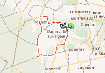
Tocht Te voet van 11,8 km beschikbaar op Île-de-France, Seine-et-Marne, Dammartin-sur-Tigeaux. Deze tocht wordt voorgesteld door CSR-94.

Beschrijving

dammartin sur tigeaux: chemin de premol

Hoogteprofiel

Plaatsbepaling

Land:
France
Regio :
Île-de-France
Departement/Provincie :
Seine-et-Marne
Gemeente :
Dammartin-sur-Tigeaux
Locatie:
Unknown
Vertrek:(UTM)
495129 ; 5407232 (31U) N.

Wandeltochten in de omgeving

Tocht Mountainbike Mortcerf - Espace VTT FFC - Les Coteaux du Morin et de l'Aubetin - Circuit n° 12 - Mortcerf - Photo
Mountainbike
tracegps

Mountainbike

Medium
(1)
Mortcerf, Île-de-France, Seine-et-Marne, France
12 km | 13,8 km-effort
1h 0min
Ja
Tocht Te voet Pommeuse - Les lavoirs de Pommeuse - Photo
Te voet
GUIDE
chessyca

Te voet

Medium
Pommeuse, Île-de-France, Seine-et-Marne, France
22 km | 26 km-effort
5h 57min
Ja
Tocht Te voet Mortcerf - Boucle autour de Mortcerf - Photo
Te voet
GUIDE
chessyca

Te voet

Heel gemakkelijk
Mortcerf, Île-de-France, Seine-et-Marne, France
22 km | 26 km-effort
5h 53min
Ja
Tocht Stappen Crécy-la-Chapelle - Boucle 28 km autour de Crecy la Chapelle - Guérard - Voulangis - Tigeaux - Photo
Stappen
GUIDE
chessyca

Stappen

Medium
Crécy-la-Chapelle, Île-de-France, Seine-et-Marne, France
28 km | 35 km-effort
5h 46min
Ja
Tocht Stappen Mortcerf - Le tour du Grand Paris via le GR1 - Etape 11 Morcerf - Verneuil l'Etang - Photo
Stappen
GUIDE
chessyca

Stappen

Medium
Mortcerf, Île-de-France, Seine-et-Marne, France
31 km | 34 km-effort
5h 41min
Neen
Tocht Stappen Mortcerf - Boucle 20 km autour de Mortcerf - Photo
Stappen
GUIDE
chessyca

Stappen

Medium
Mortcerf, Île-de-France, Seine-et-Marne, France
21 km | 25 km-effort
5h 5min
Ja
Tocht Stappen Crécy-la-Chapelle - Crécy la Chapelle Parcours normal - Photo
Stappen
CC.RIDER

Stappen

Gemakkelijk
(1)
Crécy-la-Chapelle, Île-de-France, Seine-et-Marne, France
16,1 km | 19,5 km-effort
4h 18min
Ja
Tocht Stappen Crécy-la-Chapelle - Crécy la chapelle - Photo
Stappen
CC.RIDER

Stappen

Gemakkelijk
(2)
Crécy-la-Chapelle, Île-de-France, Seine-et-Marne, France
19,7 km | 24 km-effort
5h 12min
Ja
Tocht Stappen Crécy-la-Chapelle - Crécy la Chapelle - Photo
Stappen
jctinchebray

Stappen

Medium
(1)
Crécy-la-Chapelle, Île-de-France, Seine-et-Marne, France
16,4 km | 20 km-effort
4h 23min
Ja


Sluiten
Mijn abonnementen