![](/images/other/stat-length.png)
![Tocht Andere activiteiten Zernez - w10_10_natpark - Photo](https://media.geolcdn.com/t/1900/400/ext.pjpeg?maxdim=2&url=https%3A%2F%2Fstatic1.geolcdn.com%2Fsiteimages%2Fupload%2Ffiles%2F1545311037marcheuse_200dpi.jpg)
w10_10_natpark
My Switzerland
Optez pour le retour à la nature GUIDE+
![Lengte](/images/other/stat-length.png)
Lengte
6,2 km
![Max. hoogte](https://static1.geolcdn.com/siteimages/upload/files/1508320355ic_sort_altitude_max_24dp.png)
Max. hoogte
2077 m
![Positief hoogteverschil](https://static1.geolcdn.com/siteimages/upload/files/1508320355ic_sort_den_pos_24dp.png)
Positief hoogteverschil
241 m
![Km-Effort](/images/other/stat-length.png)
Km-Effort
9,6 km
![Min. hoogte](https://static1.geolcdn.com/siteimages/upload/files/1508320355ic_sort_altitude_min_24dp.png)
Min. hoogte
1800 m
![Negatief hoogteverschil](https://static1.geolcdn.com/siteimages/upload/files/1508320355ic_sort_den_neg_24dp.png)
Negatief hoogteverschil
286 m
![Boucle](https://static1.geolcdn.com/siteimages/upload/files/16400158638029165_repeat_loop_refresh_sync_direction_icon.png)
Boucle
Neen
Datum van aanmaak :
2014-12-10 00:00:00.0
Laatste wijziging :
2014-12-10 00:00:00.0
![Andere activiteiten](https://static1.geolcdn.com/sitytour/trail-icons/900.png)
2h15
Moeilijkheid : Onbekend
![Scan deze QR-code om de tocht te openen in de SityTrail-applicatie](https://capi.geolives.com/qq0zvz2zws4bq2lad0pu/sitytour/trails/33186/qr.png?size=200)
Gratisgps-wandelapplicatie
Over ons
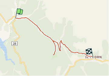
Tocht Andere activiteiten van 6,2 km beschikbaar op Graubünden, Region Engiadina Bassa/Val Müstair, Zernez. Deze tocht wordt voorgesteld door My Switzerland.
Plaatsbepaling
Land:
Switzerland
Regio :
Graubünden
Departement/Provincie :
Region Engiadina Bassa/Val Müstair
Gemeente :
Zernez
Locatie:
Unknown
Vertrek:(Dec)
Vertrek:(UTM)
589229 ; 5170234 (32T) N.
Opmerkingen
Wandeltochten in de omgeving
![Tocht Te voet Zernez - Nationalpark Wanderroute 16 (Fuorntal) - Photo](https://media.geolcdn.com/t/375/260/dev_b47906a4-0a0c-47a9-8e95-628ca5757862.jpeg&format=jpg&maxdim=2)
![Te voet Te voet](https://static1.geolcdn.com/sitytour/trail-icons/100.png)
Nationalpark Wanderroute 16 (Fuorntal)
Te voet
Gemakkelijk
Zernez,
Graubünden,
Region Engiadina Bassa/Val Müstair,
Switzerland
![](/images/other/stat-length.png)
5,1 km | 7,1 km-effort
1h 37min
![](https://static1.geolcdn.com/siteimages/upload/files/16400158638029165_repeat_loop_refresh_sync_direction_icon.png)
Neen
![Tocht Te voet Zernez - Nationalpark Wanderroute 13 (Champlönch) - Photo](https://media.geolcdn.com/t/375/260/7214e2c0-1b5b-4610-beb4-b5246d065ea1.jpeg&format=jpg&maxdim=2)
![Te voet Te voet](https://static1.geolcdn.com/sitytour/trail-icons/100.png)
Nationalpark Wanderroute 13 (Champlönch)
Te voet
Gemakkelijk
Zernez,
Graubünden,
Region Engiadina Bassa/Val Müstair,
Switzerland
![](/images/other/stat-length.png)
4,9 km | 8,3 km-effort
1h 52min
![](https://static1.geolcdn.com/siteimages/upload/files/16400158638029165_repeat_loop_refresh_sync_direction_icon.png)
Neen
![Tocht Andere activiteiten Zernez - GR National park 2 : Cluozza - Il Fuorn - Photo](https://media.geolcdn.com/t/375/260/ext.jpg?maxdim=2&url=https%3A%2F%2Fstatic1.geolcdn.com%2Fsiteimages%2Fupload%2Ffiles%2F1545311037marcheuse_200dpi.jpg)
![Andere activiteiten Andere activiteiten](https://static1.geolcdn.com/sitytour/trail-icons/900.png)
GR National park 2 : Cluozza - Il Fuorn
Andere activiteiten
Heel gemakkelijk
Zernez,
Graubünden,
Region Engiadina Bassa/Val Müstair,
Switzerland
![](/images/other/stat-length.png)
15,9 km | 32 km-effort
Onbekend
![](https://static1.geolcdn.com/siteimages/upload/files/16400158638029165_repeat_loop_refresh_sync_direction_icon.png)
Neen
![Tocht Andere activiteiten Zernez - Valaun Chafuol, Murter, Val Cluozza, Zernez - Photo](https://media.geolcdn.com/t/375/260/ext.jpg?maxdim=2&url=https%3A%2F%2Fstatic1.geolcdn.com%2Fsiteimages%2Fupload%2Ffiles%2F1545311037marcheuse_200dpi.jpg)
![Andere activiteiten Andere activiteiten](https://static1.geolcdn.com/sitytour/trail-icons/900.png)
Valaun Chafuol, Murter, Val Cluozza, Zernez
Andere activiteiten
Heel gemakkelijk
Zernez,
Graubünden,
Region Engiadina Bassa/Val Müstair,
Switzerland
![](/images/other/stat-length.png)
13,5 km | 31 km-effort
Onbekend
![](https://static1.geolcdn.com/siteimages/upload/files/16400158638029165_repeat_loop_refresh_sync_direction_icon.png)
Neen
![Tocht Andere activiteiten Zernez - Furcola Val Botsch / Sur il Foss / Costainas - Photo](https://media.geolcdn.com/t/375/260/ext.jpg?maxdim=2&url=https%3A%2F%2Fstatic1.geolcdn.com%2Fsiteimages%2Fupload%2Ffiles%2F1545311037marcheuse_200dpi.jpg)
![Andere activiteiten Andere activiteiten](https://static1.geolcdn.com/sitytour/trail-icons/900.png)
Furcola Val Botsch / Sur il Foss / Costainas
Andere activiteiten
Heel gemakkelijk
Zernez,
Graubünden,
Region Engiadina Bassa/Val Müstair,
Switzerland
![](/images/other/stat-length.png)
30 km | 49 km-effort
Onbekend
![](https://static1.geolcdn.com/siteimages/upload/files/16400158638029165_repeat_loop_refresh_sync_direction_icon.png)
Neen
![Tocht Andere activiteiten Zernez - il fuorn Ova spin - Photo](https://media.geolcdn.com/t/375/260/ext.jpg?maxdim=2&url=https%3A%2F%2Fstatic1.geolcdn.com%2Fsiteimages%2Fupload%2Ffiles%2F1545311037marcheuse_200dpi.jpg)
![Andere activiteiten Andere activiteiten](https://static1.geolcdn.com/sitytour/trail-icons/900.png)
il fuorn Ova spin
Andere activiteiten
Heel gemakkelijk
Zernez,
Graubünden,
Region Engiadina Bassa/Val Müstair,
Switzerland
![](/images/other/stat-length.png)
6,1 km | 11 km-effort
Onbekend
![](https://static1.geolcdn.com/siteimages/upload/files/16400158638029165_repeat_loop_refresh_sync_direction_icon.png)
Neen
![Tocht Andere activiteiten Zernez - Buffalora munt la shera - Photo](https://media.geolcdn.com/t/375/260/ext.jpg?maxdim=2&url=https%3A%2F%2Fstatic1.geolcdn.com%2Fsiteimages%2Fupload%2Ffiles%2F1545311037marcheuse_200dpi.jpg)
![Andere activiteiten Andere activiteiten](https://static1.geolcdn.com/sitytour/trail-icons/900.png)
Buffalora munt la shera
Andere activiteiten
Heel gemakkelijk
Zernez,
Graubünden,
Region Engiadina Bassa/Val Müstair,
Switzerland
![](/images/other/stat-length.png)
16,4 km | 28 km-effort
Onbekend
![](https://static1.geolcdn.com/siteimages/upload/files/16400158638029165_repeat_loop_refresh_sync_direction_icon.png)
Ja
![Tocht Andere activiteiten Zernez - il fuorn Margunet - Photo](https://media.geolcdn.com/t/375/260/ext.jpg?maxdim=2&url=https%3A%2F%2Fstatic1.geolcdn.com%2Fsiteimages%2Fupload%2Ffiles%2F1545311037marcheuse_200dpi.jpg)
![Andere activiteiten Andere activiteiten](https://static1.geolcdn.com/sitytour/trail-icons/900.png)
il fuorn Margunet
Andere activiteiten
Heel gemakkelijk
Zernez,
Graubünden,
Region Engiadina Bassa/Val Müstair,
Switzerland
![](/images/other/stat-length.png)
6,3 km | 12,5 km-effort
Onbekend
![](https://static1.geolcdn.com/siteimages/upload/files/16400158638029165_repeat_loop_refresh_sync_direction_icon.png)
Ja
![Tocht Andere activiteiten Zernez - GR / nationalpark 2 - Photo](https://media.geolcdn.com/t/375/260/ext.jpg?maxdim=2&url=https%3A%2F%2Fstatic1.geolcdn.com%2Fsiteimages%2Fupload%2Ffiles%2F1545311037marcheuse_200dpi.jpg)
![Andere activiteiten Andere activiteiten](https://static1.geolcdn.com/sitytour/trail-icons/900.png)
GR / nationalpark 2
Andere activiteiten
Heel gemakkelijk
Zernez,
Graubünden,
Region Engiadina Bassa/Val Müstair,
Switzerland
![](/images/other/stat-length.png)
8 km | 13,7 km-effort
Onbekend
![](https://static1.geolcdn.com/siteimages/upload/files/16400158638029165_repeat_loop_refresh_sync_direction_icon.png)
Neen