![](/images/other/stat-length.png)
![Tocht Stappen Gigondas - 2022-07-09_07h40m06_gigondas-2022-10-4 - Photo](https://media.geolcdn.com/t/1900/400/ext.pjpeg?maxdim=2&url=https%3A%2F%2Fstatic1.geolcdn.com%2Fsiteimages%2Fupload%2Ffiles%2F1553511878bg_sport_marche.png)
2022-07-09_07h40m06_gigondas-2022-10-4
DanielROLLET
Gebruiker
![Lengte](/images/other/stat-length.png)
Lengte
10,4 km
![Max. hoogte](https://static1.geolcdn.com/siteimages/upload/files/1508320355ic_sort_altitude_max_24dp.png)
Max. hoogte
490 m
![Positief hoogteverschil](https://static1.geolcdn.com/siteimages/upload/files/1508320355ic_sort_den_pos_24dp.png)
Positief hoogteverschil
360 m
![Km-Effort](/images/other/stat-length.png)
Km-Effort
15,2 km
![Min. hoogte](https://static1.geolcdn.com/siteimages/upload/files/1508320355ic_sort_altitude_min_24dp.png)
Min. hoogte
240 m
![Negatief hoogteverschil](https://static1.geolcdn.com/siteimages/upload/files/1508320355ic_sort_den_neg_24dp.png)
Negatief hoogteverschil
357 m
![Boucle](https://static1.geolcdn.com/siteimages/upload/files/16400158638029165_repeat_loop_refresh_sync_direction_icon.png)
Boucle
Ja
Datum van aanmaak :
2022-07-09 05:40:06.231
Laatste wijziging :
2022-07-16 19:32:50.059
![Stappen](https://static1.geolcdn.com/sitytour/trail-icons/101.png)
4h30
Moeilijkheid : Moeilijk
![Scan deze QR-code om de tocht te openen in de SityTrail-applicatie](https://capi.geolives.com/qq0zvz2zws4bq2lad0pu/sitytour/trails/3309435/qr.png?size=200)
Gratisgps-wandelapplicatie
Over ons
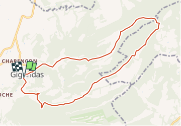
Tocht Stappen van 10,4 km beschikbaar op Provence-Alpes-Côte d'Azur, Vaucluse, Gigondas. Deze tocht wordt voorgesteld door DanielROLLET.
Beschrijving
2022 07 09 - Avec Marie - 9h00 à 13h30
Départ/Arrivée Marie de Gigondas
Pas de l'Aigle, pause au Col du Cayron, Rocher du Midi.
Marche réduite en raison d'une interdiction d’accès dans le massif des Dentelles
Fin de parcours par 32°
Plaatsbepaling
Land:
France
Regio :
Provence-Alpes-Côte d'Azur
Departement/Provincie :
Vaucluse
Gemeente :
Gigondas
Locatie:
Unknown
Vertrek:(Dec)
Vertrek:(UTM)
660249 ; 4891969 (31T) N.
Opmerkingen
Wandeltochten in de omgeving
![Tocht Stappen Séguret - 170917 EnCours - Photo](https://media.geolcdn.com/t/375/260/ext.jpg?maxdim=2&url=https%3A%2F%2Fservices.sitytrail.com%2FGeolivesWS%2FDownloadMedia.ashx%3FTrailID%3D831554%26Media%3Dfix__20170917163021.jpg)
![Stappen Stappen](https://static1.geolcdn.com/sitytour/trail-icons/101.png)
170917 EnCours
Stappen
Heel gemakkelijk
(1)
Séguret,
Provence-Alpes-Côte d'Azur,
Vaucluse,
France
![](/images/other/stat-length.png)
6,3 km | 9,8 km-effort
2h 8min
![](https://static1.geolcdn.com/siteimages/upload/files/16400158638029165_repeat_loop_refresh_sync_direction_icon.png)
Ja
![Tocht Stappen Gigondas - Dentelles Montmirail - Gigondas - Photo](https://media.geolcdn.com/t/375/260/ext.jpg?maxdim=2&url=https%3A%2F%2Fservices.sitytrail.com%2FGeolivesWS%2FDownloadMedia.ashx%3FTrailID%3D173036%26Media%3D14549_6.jpg)
![Stappen Stappen](https://static1.geolcdn.com/sitytour/trail-icons/101.png)
Dentelles Montmirail - Gigondas
Stappen
Zeer moeilijk
(3)
Gigondas,
Provence-Alpes-Côte d'Azur,
Vaucluse,
France
![](/images/other/stat-length.png)
12,4 km | 22 km-effort
7h 0min
![](https://static1.geolcdn.com/siteimages/upload/files/16400158638029165_repeat_loop_refresh_sync_direction_icon.png)
Ja
![Tocht Stappen Lafare - Le tour du Grand Montmirail - Lafare - Photo](https://media.geolcdn.com/t/375/260/ext.jpg?maxdim=2&url=https%3A%2F%2Fservices.sitytrail.com%2FGeolivesWS%2FDownloadMedia.ashx%3FTrailID%3D107159%26Media%3D12002_4.jpg)
![Stappen Stappen](https://static1.geolcdn.com/sitytour/trail-icons/101.png)
Le tour du Grand Montmirail - Lafare
Stappen
Medium
(3)
Lafare,
Provence-Alpes-Côte d'Azur,
Vaucluse,
France
![](/images/other/stat-length.png)
9,1 km | 13,9 km-effort
2h 30min
![](https://static1.geolcdn.com/siteimages/upload/files/16400158638029165_repeat_loop_refresh_sync_direction_icon.png)
Ja
![Tocht Stappen Lafare - Une approche des Dentelles de Montmirail - Photo](https://media.geolcdn.com/t/375/260/ext.jpg?maxdim=2&url=https%3A%2F%2Fservices.sitytrail.com%2FGeolivesWS%2FDownloadMedia.ashx%3FTrailID%3D191525%26Media%3D15129_1.jpg)
![Stappen Stappen](https://static1.geolcdn.com/sitytour/trail-icons/101.png)
Une approche des Dentelles de Montmirail
Stappen
Medium
(2)
Lafare,
Provence-Alpes-Côte d'Azur,
Vaucluse,
France
![](/images/other/stat-length.png)
6,6 km | 11,4 km-effort
3h 0min
![](https://static1.geolcdn.com/siteimages/upload/files/16400158638029165_repeat_loop_refresh_sync_direction_icon.png)
Ja
![Tocht Stappen Gigondas - 84 dentelles montmirail - Photo](https://media.geolcdn.com/t/375/260/db267071-8c80-4579-b337-475840d4394d.jpg&format=jpg&maxdim=2)
![Stappen Stappen](https://static1.geolcdn.com/sitytour/trail-icons/101.png)
84 dentelles montmirail
Stappen
Moeilijk
Gigondas,
Provence-Alpes-Côte d'Azur,
Vaucluse,
France
![](/images/other/stat-length.png)
14,6 km | 25 km-effort
8h 18min
![](https://static1.geolcdn.com/siteimages/upload/files/16400158638029165_repeat_loop_refresh_sync_direction_icon.png)
Ja
![Tocht Stappen Gigondas - Gigondas Dentelles Sarasines Grande Montagne - Photo](https://media.geolcdn.com/t/375/260/343b4e0d-071e-4a7e-8b9e-ca660a28ad4c.jpg&format=jpg&maxdim=2)
![Stappen Stappen](https://static1.geolcdn.com/sitytour/trail-icons/101.png)
Gigondas Dentelles Sarasines Grande Montagne
Stappen
Moeilijk
(1)
Gigondas,
Provence-Alpes-Côte d'Azur,
Vaucluse,
France
![](/images/other/stat-length.png)
15,4 km | 26 km-effort
5h 57min
![](https://static1.geolcdn.com/siteimages/upload/files/16400158638029165_repeat_loop_refresh_sync_direction_icon.png)
Ja
![Tocht Stappen Gigondas - Grand Montmirail par 3 Yeux - Photo](https://media.geolcdn.com/t/375/260/ext.jpg?maxdim=2&url=https%3A%2F%2Fstatic1.geolcdn.com%2Fsiteimages%2Fupload%2Ffiles%2F1553511878bg_sport_marche.png)
![Stappen Stappen](https://static1.geolcdn.com/sitytour/trail-icons/101.png)
Grand Montmirail par 3 Yeux
Stappen
Medium
(2)
Gigondas,
Provence-Alpes-Côte d'Azur,
Vaucluse,
France
![](/images/other/stat-length.png)
13,3 km | 21 km-effort
4h 29min
![](https://static1.geolcdn.com/siteimages/upload/files/16400158638029165_repeat_loop_refresh_sync_direction_icon.png)
Ja
![Tocht Stappen Gigondas - dentelles de Montmirail - Photo](https://media.geolcdn.com/t/375/260/ext.jpg?maxdim=2&url=https%3A%2F%2Fstatic1.geolcdn.com%2Fsiteimages%2Fupload%2Ffiles%2F1553511878bg_sport_marche.png)
![Stappen Stappen](https://static1.geolcdn.com/sitytour/trail-icons/101.png)
dentelles de Montmirail
Stappen
Heel gemakkelijk
(1)
Gigondas,
Provence-Alpes-Côte d'Azur,
Vaucluse,
France
![](/images/other/stat-length.png)
15,7 km | 26 km-effort
8h 9min
![](https://static1.geolcdn.com/siteimages/upload/files/16400158638029165_repeat_loop_refresh_sync_direction_icon.png)
Ja
![Tocht Stappen Gigondas - les dentelles de Montmirail depuis Gigondas - Photo](https://media.geolcdn.com/t/375/260/ext.jpg?maxdim=2&url=https%3A%2F%2Fstatic1.geolcdn.com%2Fsiteimages%2Fupload%2Ffiles%2F1553511878bg_sport_marche.png)
![Stappen Stappen](https://static1.geolcdn.com/sitytour/trail-icons/101.png)
les dentelles de Montmirail depuis Gigondas
Stappen
Medium
(4)
Gigondas,
Provence-Alpes-Côte d'Azur,
Vaucluse,
France
![](/images/other/stat-length.png)
6,6 km | 11,3 km-effort
2h 26min
![](https://static1.geolcdn.com/siteimages/upload/files/16400158638029165_repeat_loop_refresh_sync_direction_icon.png)
Ja