Tocht Mountainbike Virton - Ethe II  -  Balade_VTT_14kms - Photo

Ethe II - Balade_VTT_14kms

 Pascal L
Pascal L

Gebruiker

© OpenStreetMap contributors
Lengte
Lengte
13,3 km
Max. hoogte
Max. hoogte
372 m
Positief hoogteverschil
220 m
Km-Effort
Km-Effort  
16,3 km
Min. hoogte
Min. hoogte
209 m
Negatief hoogteverschil
221 m
Boucle
Boucle
Ja
Datum van aanmaak :
2022-06-22 09:42:36.092
Laatste wijziging :
2022-11-05 15:45:38.262

(0 Bericht)

Mountainbike
Mountainbike
1h10
Moeilijkheid : Gemakkelijk

Scan deze QR-code om de tocht te openen in de SityTrail-applicatie

Gratisgps-wandelapplicatie

Logo SityTrail SityTrail

IGN / Geografische instituten

SityTrail uit de App Store downloaden SityTrail uit Google Play downloaden

Logo SityTrail SityTrail World

De wereld gaat voor u open

SityTrail uit de App Store downloaden SityTrail uit Google Play downloaden SityTrail op Huawei AppGallery downloaden

Over ons

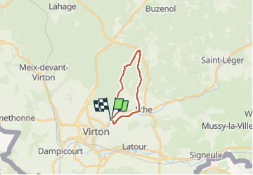
Tocht Mountainbike van 13,3 km beschikbaar op Wallonië, Luxemburg, Virton. Deze tocht wordt voorgesteld door Pascal L.

Beschrijving

Aller/Retour: Virton (Pierrard)
Endroits de passage: Fagne Pierrard, Vallée de Rabais, Bois du Bonlieu, le Terme, le Chenoi, Belmont, Réserve Naturelle des Marais du Ton, Moulin de Bohez, Ravel (ligne 155)

Video:
1) https://vimeo.com/741048763

Ref.
1. https://fr.wikipedia.org/wiki/Belmont_(Gaume)
2. https://fr.wikipedia.org/wiki/Ethe
3. http://biodiversite.wallonie.be/fr/6925-marais-du-ton.html?IDD=335545245&IDC=2831

Hoogteprofiel

Foto's

27 fotos in totaal. Klik op een foto om ze allemaal in de galerij weer te geven.

Plaatsbepaling

Land:
Belgium
Regio :
Wallonië
Departement/Provincie :
Luxemburg
Gemeente :
Virton
Locatie:
Virton
Vertrek:(UTM)
684227 ; 5494486 (31U) N.

Wandeltochten in de omgeving

Tocht Stappen Virton - RB-Lu-17_Ethe_via-var-1-et-2-et-3 - Photo
Stappen
PRO

Stappen

Heel gemakkelijk
(3)
Virton, Wallonië, Luxemburg, Belgium
29 km | 35 km-effort
7h 33min
Ja
Tocht Mountainbike Virton - T2019-06-16-16-47 - Photo
Mountainbike
Pascal L

Mountainbike

Gemakkelijk
(1)
Virton, Wallonië, Luxemburg, Belgium
21 km | 26 km-effort
1h 40min
Ja
Tocht Stappen Virton - GAUME Balade  naturelle et historique - Photo
Stappen
julucasi

Stappen

Heel gemakkelijk
(1)
Virton, Wallonië, Luxemburg, Belgium
5,2 km | 6,8 km-effort
1h 16min
Ja
Tocht Te voet Virton - La Bajocienne - Photo
Te voet
GUIDE+

Te voet

Gemakkelijk
(1)
Virton, Wallonië, Luxemburg, Belgium
11 km | 14,5 km-effort
3h 17min
Ja
Tocht Stappen Virton - RB-Lu-17_Ethe_via-racc - Photo
Stappen
PRO

Stappen

Heel gemakkelijk
Virton, Wallonië, Luxemburg, Belgium
15,6 km | 19,3 km-effort
4h 8min
Ja
Tocht Stappen Virton - RB-Lu-17_Ethe - Photo
Stappen
PRO

Stappen

Heel gemakkelijk
Virton, Wallonië, Luxemburg, Belgium
22 km | 28 km-effort
5h 55min
Ja
Tocht Mountainbike Virton - Autour de Tintigny  -  Balade_VTT_54Kms - Photo
Mountainbike
Pascal L

Mountainbike

Zeer moeilijk
Virton, Wallonië, Luxemburg, Belgium
54 km | 64 km-effort
4h 25min
Ja
Tocht Mountainbike Virton - Monquintin  -  Balade_VTT_22Kms - Photo
Mountainbike
Pascal L

Mountainbike

Medium
Virton, Wallonië, Luxemburg, Belgium
22 km | 26 km-effort
1h 48min
Ja
Tocht Mountainbike Virton - Orval  -  Balade_VTT_50Kms - Photo
Mountainbike
Pascal L

Mountainbike

Zeer moeilijk
Virton, Wallonië, Luxemburg, Belgium
50 km | 61 km-effort
4h 15min
Neen


Sluiten
Mijn abonnementen