


kasþanoa

lecanuf
Gebruiker
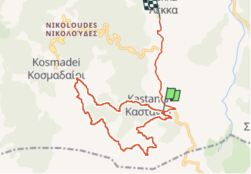

Lengte
11,2 km

Max. hoogte
665 m

Positief hoogteverschil
412 m
Km-Effort
17 km

Min. hoogte
241 m

Negatief hoogteverschil
499 m
Boucle
Neen
Datum van aanmaak :
2022-06-17 07:30:30.916
Laatste wijziging :
2022-06-17 10:45:16.863
3h13
Moeilijkheid : Moeilijk

Gratisgps-wandelapplicatie
 SityTrail
IGN / Geografische instituten
SityTrail World
De wereld gaat voor u open
Over ons
Tocht Stappen van 11,2 km beschikbaar op Egeïsche Eilanden, Περιφερειακή Ενότητα Σάμου, Δημοτική Ενότητα Καρλοβασίων. Deze tocht wordt voorgesteld door lecanuf.
Beschrijving
facile
Plaatsbepaling
Land:
Greece
Regio :
Egeïsche Eilanden
Departement/Provincie :
Περιφερειακή Ενότητα Σάμου
Gemeente :
Δημοτική Ενότητα Καρλοβασίων
Locatie:
Unknown
Vertrek:(Dec)
Vertrek:(UTM)
472484 ; 4178381 (35S) N.
Opmerkingen
Wandeltochten in de omgeving