![](/images/other/stat-length.png)
![Tocht Lopen Le Lac-d'Issarlès - lac d'issarles et plus - Photo](https://media.geolcdn.com/t/1900/400/1bd8325c-1f9d-4573-8673-f1d7610330c8.jpg&format=pjpeg&maxdim=2)
lac d'issarles et plus
nadd73
Gebruiker GUIDE
![Lengte](/images/other/stat-length.png)
Lengte
16,8 km
![Max. hoogte](https://static1.geolcdn.com/siteimages/upload/files/1508320355ic_sort_altitude_max_24dp.png)
Max. hoogte
1268 m
![Positief hoogteverschil](https://static1.geolcdn.com/siteimages/upload/files/1508320355ic_sort_den_pos_24dp.png)
Positief hoogteverschil
601 m
![Km-Effort](/images/other/stat-length.png)
Km-Effort
25 km
![Min. hoogte](https://static1.geolcdn.com/siteimages/upload/files/1508320355ic_sort_altitude_min_24dp.png)
Min. hoogte
896 m
![Negatief hoogteverschil](https://static1.geolcdn.com/siteimages/upload/files/1508320355ic_sort_den_neg_24dp.png)
Negatief hoogteverschil
581 m
![Boucle](https://static1.geolcdn.com/siteimages/upload/files/16400158638029165_repeat_loop_refresh_sync_direction_icon.png)
Boucle
Ja
Datum van aanmaak :
2022-06-14 08:47:45.712
Laatste wijziging :
2022-06-14 16:33:34.317
![Lopen](https://static1.geolcdn.com/sitytour/trail-icons/103.png)
2h26
Moeilijkheid : Medium
![Scan deze QR-code om de tocht te openen in de SityTrail-applicatie](https://capi.geolives.com/qq0zvz2zws4bq2lad0pu/sitytour/trails/3282296/qr.png?size=200)
Gratisgps-wandelapplicatie
Over ons
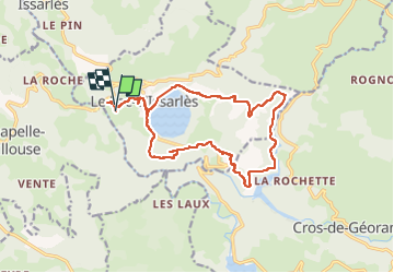
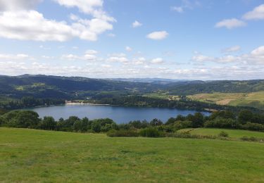
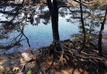
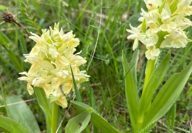
Tocht Lopen van 16,8 km beschikbaar op Auvergne-Rhône-Alpes, Ardèche, Le Lac-d'Issarlès. Deze tocht wordt voorgesteld door nadd73.
Beschrijving
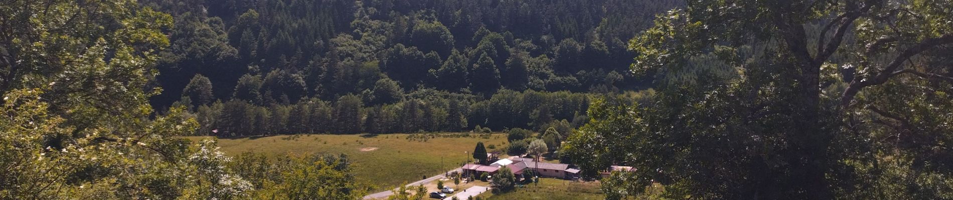
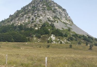
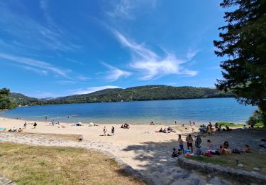
De la longueur, parfois sur route 😒, mais de beaux points de vue. Et surtout baignade bien méritée !
Plaatsbepaling
Land:
France
Regio :
Auvergne-Rhône-Alpes
Departement/Provincie :
Ardèche
Gemeente :
Le Lac-d'Issarlès
Locatie:
Unknown
Vertrek:(Dec)
Vertrek:(UTM)
583269 ; 4963295 (31T) N.
Opmerkingen
Wandeltochten in de omgeving
![Tocht Wegfiets Le Lac-d'Issarlès - col de Mezilhac et le Gerbier de jonc - Photo](https://media.geolcdn.com/t/375/260/84eb115d-5a09-4b75-8fe9-ba40b19ff9a4.jpg&format=jpg&maxdim=2)
![Wegfiets Wegfiets](https://static1.geolcdn.com/sitytour/trail-icons/201.png)
col de Mezilhac et le Gerbier de jonc
Wegfiets
Medium
Le Lac-d'Issarlès,
Auvergne-Rhône-Alpes,
Ardèche,
France
![](/images/other/stat-length.png)
72 km | 91 km-effort
2h 57min
![](https://static1.geolcdn.com/siteimages/upload/files/16400158638029165_repeat_loop_refresh_sync_direction_icon.png)
Ja
![Tocht Stappen Le Lac-d'Issarlès - Grand tour lac d'Issarlès - Photo](https://media.geolcdn.com/t/375/260/97ff9f11-f883-4bfc-9be1-40ea930c8a38.jpg&format=jpg&maxdim=2)
![Stappen Stappen](https://static1.geolcdn.com/sitytour/trail-icons/101.png)
Grand tour lac d'Issarlès
Stappen
Medium
Le Lac-d'Issarlès,
Auvergne-Rhône-Alpes,
Ardèche,
France
![](/images/other/stat-length.png)
10,3 km | 15,5 km-effort
3h 37min
![](https://static1.geolcdn.com/siteimages/upload/files/16400158638029165_repeat_loop_refresh_sync_direction_icon.png)
Ja
![Tocht Te voet Le Lac-d'Issarlès - Le tour du Lac - Photo](https://media.geolcdn.com/t/375/260/0693bdf7-a39e-426d-8dba-718f752c6269.jpeg&format=jpg&maxdim=2)
![Te voet Te voet](https://static1.geolcdn.com/sitytour/trail-icons/100.png)
Le tour du Lac
Te voet
Gemakkelijk
Le Lac-d'Issarlès,
Auvergne-Rhône-Alpes,
Ardèche,
France
![](/images/other/stat-length.png)
3,6 km | 4,6 km-effort
1h 2min
![](https://static1.geolcdn.com/siteimages/upload/files/16400158638029165_repeat_loop_refresh_sync_direction_icon.png)
Ja
![Tocht Stappen Le Lac-d'Issarlès - Lac d'Issarlès - Photo](https://media.geolcdn.com/t/375/260/c71a34a0-683a-4be1-851e-d79c1049de75.jpg&format=jpg&maxdim=2)
![Stappen Stappen](https://static1.geolcdn.com/sitytour/trail-icons/101.png)
Lac d'Issarlès
Stappen
Medium
Le Lac-d'Issarlès,
Auvergne-Rhône-Alpes,
Ardèche,
France
![](/images/other/stat-length.png)
6,2 km | 8,9 km-effort
2h 0min
![](https://static1.geolcdn.com/siteimages/upload/files/16400158638029165_repeat_loop_refresh_sync_direction_icon.png)
Neen
![Tocht Stappen Le Lac-d'Issarlès - issarles - Photo](https://media.geolcdn.com/t/375/260/5552bece-5b01-4409-8571-badda5bcdcf8.jpg&format=jpg&maxdim=2)
![Stappen Stappen](https://static1.geolcdn.com/sitytour/trail-icons/101.png)
issarles
Stappen
Heel gemakkelijk
Le Lac-d'Issarlès,
Auvergne-Rhône-Alpes,
Ardèche,
France
![](/images/other/stat-length.png)
4,4 km | 5,7 km-effort
1h 16min
![](https://static1.geolcdn.com/siteimages/upload/files/16400158638029165_repeat_loop_refresh_sync_direction_icon.png)
Ja
![Tocht Mountainbike Issarlès - Les plos-Coucouron en boucle - Photo](https://media.geolcdn.com/t/375/260/ext.jpg?maxdim=2&url=https%3A%2F%2Fstatic1.geolcdn.com%2Fsiteimages%2Fupload%2Ffiles%2F1524743154velo.jpg)
![Mountainbike Mountainbike](https://static1.geolcdn.com/sitytour/trail-icons/202.png)
Les plos-Coucouron en boucle
Mountainbike
Medium
Issarlès,
Auvergne-Rhône-Alpes,
Ardèche,
France
![](/images/other/stat-length.png)
31 km | 40 km-effort
3h 30min
![](https://static1.geolcdn.com/siteimages/upload/files/16400158638029165_repeat_loop_refresh_sync_direction_icon.png)
Ja
![Tocht Mountainbike Issarlès - autour du lac d'Issarles 33km - Photo](https://media.geolcdn.com/t/375/260/ext.jpg?maxdim=2&url=https%3A%2F%2Fstatic1.geolcdn.com%2Fsiteimages%2Fupload%2Ffiles%2F1524743154velo.jpg)
![Mountainbike Mountainbike](https://static1.geolcdn.com/sitytour/trail-icons/202.png)
autour du lac d'Issarles 33km
Mountainbike
Moeilijk
Issarlès,
Auvergne-Rhône-Alpes,
Ardèche,
France
![](/images/other/stat-length.png)
33 km | 47 km-effort
3h 30min
![](https://static1.geolcdn.com/siteimages/upload/files/16400158638029165_repeat_loop_refresh_sync_direction_icon.png)
Ja
![Tocht Mountainbike Issarlès - 45 km depuis issarles - Photo](https://media.geolcdn.com/t/375/260/ext.jpg?maxdim=2&url=https%3A%2F%2Fstatic1.geolcdn.com%2Fsiteimages%2Fupload%2Ffiles%2F1524743154velo.jpg)
![Mountainbike Mountainbike](https://static1.geolcdn.com/sitytour/trail-icons/202.png)
45 km depuis issarles
Mountainbike
Moeilijk
Issarlès,
Auvergne-Rhône-Alpes,
Ardèche,
France
![](/images/other/stat-length.png)
42 km | 55 km-effort
4h 35min
![](https://static1.geolcdn.com/siteimages/upload/files/16400158638029165_repeat_loop_refresh_sync_direction_icon.png)
Ja
![Tocht sport Le Lac-d'Issarlès - Autour du Lac d’Issarles - Photo](https://media.geolcdn.com/t/375/260/e2ba9628-e12a-4927-ab4e-4e65f7438a96.jpg&format=jpg&maxdim=2)
Autour du Lac d’Issarles
sport
Heel gemakkelijk
Le Lac-d'Issarlès,
Auvergne-Rhône-Alpes,
Ardèche,
France
![](/images/other/stat-length.png)
10,2 km | 14,5 km-effort
Onbekend
![](https://static1.geolcdn.com/siteimages/upload/files/16400158638029165_repeat_loop_refresh_sync_direction_icon.png)
Ja