![](/images/other/stat-length.png)
![Tocht Stappen Houppeville - houppeville 1 - Photo](https://media.geolcdn.com/t/1900/400/ext.pjpeg?maxdim=2&url=https%3A%2F%2Fstatic1.geolcdn.com%2Fsiteimages%2Fupload%2Ffiles%2F1553511878bg_sport_marche.png)
houppeville 1
nicole.reine@wanadoo.fr
Gebruiker
![Lengte](/images/other/stat-length.png)
Lengte
6,1 km
![Max. hoogte](https://static1.geolcdn.com/siteimages/upload/files/1508320355ic_sort_altitude_max_24dp.png)
Max. hoogte
163 m
![Positief hoogteverschil](https://static1.geolcdn.com/siteimages/upload/files/1508320355ic_sort_den_pos_24dp.png)
Positief hoogteverschil
59 m
![Km-Effort](/images/other/stat-length.png)
Km-Effort
6,9 km
![Min. hoogte](https://static1.geolcdn.com/siteimages/upload/files/1508320355ic_sort_altitude_min_24dp.png)
Min. hoogte
126 m
![Negatief hoogteverschil](https://static1.geolcdn.com/siteimages/upload/files/1508320355ic_sort_den_neg_24dp.png)
Negatief hoogteverschil
60 m
![Boucle](https://static1.geolcdn.com/siteimages/upload/files/16400158638029165_repeat_loop_refresh_sync_direction_icon.png)
Boucle
Ja
Datum van aanmaak :
2014-12-10 00:00:00.0
Laatste wijziging :
2014-12-10 00:00:00.0
![Stappen](https://static1.geolcdn.com/sitytour/trail-icons/101.png)
1h31
Moeilijkheid : Gemakkelijk
![Scan deze QR-code om de tocht te openen in de SityTrail-applicatie](https://capi.geolives.com/qq0zvz2zws4bq2lad0pu/sitytour/trails/326861/qr.png?size=200)
Gratisgps-wandelapplicatie
Over ons
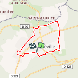
Tocht Stappen van 6,1 km beschikbaar op Normandië, Seine-Maritime, Houppeville. Deze tocht wordt voorgesteld door nicole.reine@wanadoo.fr.
Beschrijving
depart salle du vivier ,près de l'église et se diriger vers la foret pour avoir moins de dénivelé en passant à la rue jolio curie
Plaatsbepaling
Land:
France
Regio :
Normandië
Departement/Provincie :
Seine-Maritime
Gemeente :
Houppeville
Locatie:
Unknown
Vertrek:(Dec)
Vertrek:(UTM)
360866 ; 5485674 (31U) N.
Opmerkingen
Wandeltochten in de omgeving
![Tocht Stappen Mont-Saint-Aignan - Mont-saint-aignan - Chasse-Marée - - Photo](https://media.geolcdn.com/t/375/260/9cf681a4-2bd4-44f5-95c9-4e27e69bf20e.jpg&format=jpg&maxdim=2)
![Stappen Stappen](https://static1.geolcdn.com/sitytour/trail-icons/101.png)
Mont-saint-aignan - Chasse-Marée -
Stappen
Moeilijk
(1)
Mont-Saint-Aignan,
Normandië,
Seine-Maritime,
France
![](/images/other/stat-length.png)
11,7 km | 15,2 km-effort
3h 27min
![](https://static1.geolcdn.com/siteimages/upload/files/16400158638029165_repeat_loop_refresh_sync_direction_icon.png)
Ja
![Tocht Stappen Montville - 076-40-Montville par Mont Cauvaire 13km-801-928- - Photo](https://media.geolcdn.com/t/375/260/2ec38968-b205-4a2d-b7e0-d55347b674fd.jpg&format=jpg&maxdim=2)
![Stappen Stappen](https://static1.geolcdn.com/sitytour/trail-icons/101.png)
076-40-Montville par Mont Cauvaire 13km-801-928-
Stappen
Medium
(1)
Montville,
Normandië,
Seine-Maritime,
France
![](/images/other/stat-length.png)
12,7 km | 16,1 km-effort
3h 27min
![](https://static1.geolcdn.com/siteimages/upload/files/16400158638029165_repeat_loop_refresh_sync_direction_icon.png)
Ja
![Tocht Stappen Le Houlme - 076-65-le Houlme Malaunay Canicule 9km - Photo](https://media.geolcdn.com/t/375/260/cf5018c2-c685-4aa8-b115-bf28ee60bc47.jpg&format=jpg&maxdim=2)
![Stappen Stappen](https://static1.geolcdn.com/sitytour/trail-icons/101.png)
076-65-le Houlme Malaunay Canicule 9km
Stappen
Medium
(1)
Le Houlme,
Normandië,
Seine-Maritime,
France
![](/images/other/stat-length.png)
10 km | 13,7 km-effort
2h 56min
![](https://static1.geolcdn.com/siteimages/upload/files/16400158638029165_repeat_loop_refresh_sync_direction_icon.png)
Ja
![Stappen Stappen](https://static1.geolcdn.com/sitytour/trail-icons/101.png)
20231026-Le Houlme
Stappen
Medium
Le Houlme,
Normandië,
Seine-Maritime,
France
![](/images/other/stat-length.png)
12 km | 15,7 km-effort
3h 29min
![](https://static1.geolcdn.com/siteimages/upload/files/16400158638029165_repeat_loop_refresh_sync_direction_icon.png)
Ja
![Tocht Noords wandelen Bois-Guillaume - MN - Bois-Guillaume - Bretèque - Photo](https://media.geolcdn.com/t/375/260/ext.jpg?maxdim=2&url=https%3A%2F%2Fstatic1.geolcdn.com%2Fsiteimages%2Fupload%2Ffiles%2F1545311037marcheuse_200dpi.jpg)
![Noords wandelen Noords wandelen](https://static1.geolcdn.com/sitytour/trail-icons/102.png)
MN - Bois-Guillaume - Bretèque
Noords wandelen
Heel gemakkelijk
(1)
Bois-Guillaume,
Normandië,
Seine-Maritime,
France
![](/images/other/stat-length.png)
6,9 km | 7,9 km-effort
1h 15min
![](https://static1.geolcdn.com/siteimages/upload/files/16400158638029165_repeat_loop_refresh_sync_direction_icon.png)
Ja
![Stappen Stappen](https://static1.geolcdn.com/sitytour/trail-icons/101.png)
2023-09-09_18h54m19_activity_la_breteque_2VAUbDmYip1bXIXdp2Rh75Nga7h
Stappen
Moeilijk
Houppeville,
Normandië,
Seine-Maritime,
France
![](/images/other/stat-length.png)
11,3 km | 14,4 km-effort
3h 16min
![](https://static1.geolcdn.com/siteimages/upload/files/16400158638029165_repeat_loop_refresh_sync_direction_icon.png)
Ja
![Stappen Stappen](https://static1.geolcdn.com/sitytour/trail-icons/101.png)
20230829-Déville les Rouen
Stappen
Medium
Déville-lès-Rouen,
Normandië,
Seine-Maritime,
France
![](/images/other/stat-length.png)
11,9 km | 16,3 km-effort
3h 38min
![](https://static1.geolcdn.com/siteimages/upload/files/16400158638029165_repeat_loop_refresh_sync_direction_icon.png)
Ja
![Tocht Stappen Déville-lès-Rouen - 20230504-Déville les Rouen - Photo](https://media.geolcdn.com/t/375/260/eed96392-23a7-4859-84f4-8afb1f8dae77.jpg&format=jpg&maxdim=2)
![Stappen Stappen](https://static1.geolcdn.com/sitytour/trail-icons/101.png)
20230504-Déville les Rouen
Stappen
Medium
Déville-lès-Rouen,
Normandië,
Seine-Maritime,
France
![](/images/other/stat-length.png)
10,9 km | 15,2 km-effort
3h 31min
![](https://static1.geolcdn.com/siteimages/upload/files/16400158638029165_repeat_loop_refresh_sync_direction_icon.png)
Ja
![Tocht Stappen Bosc-Guérard-Saint-Adrien - Bosc Guerard - Photo](https://media.geolcdn.com/t/375/260/ext.jpg?maxdim=2&url=https%3A%2F%2Fstatic1.geolcdn.com%2Fsiteimages%2Fupload%2Ffiles%2F1553511878bg_sport_marche.png)
![Stappen Stappen](https://static1.geolcdn.com/sitytour/trail-icons/101.png)
Bosc Guerard
Stappen
(1)
Bosc-Guérard-Saint-Adrien,
Normandië,
Seine-Maritime,
France
![](/images/other/stat-length.png)
9,4 km | 11,5 km-effort
Onbekend
![](https://static1.geolcdn.com/siteimages/upload/files/16400158638029165_repeat_loop_refresh_sync_direction_icon.png)
Ja