![](/images/other/stat-length.png)
![Tocht Stappen Ustou - GR10 2022 - J2 - Photo](https://media.geolcdn.com/t/1900/400/ext.pjpeg?maxdim=2&url=https%3A%2F%2Fstatic1.geolcdn.com%2Fsiteimages%2Fupload%2Ffiles%2F1553511878bg_sport_marche.png)
GR10 2022 - J2
JM Heine
Gebruiker
![Lengte](/images/other/stat-length.png)
Lengte
14,8 km
![Max. hoogte](https://static1.geolcdn.com/siteimages/upload/files/1508320355ic_sort_altitude_max_24dp.png)
Max. hoogte
1656 m
![Positief hoogteverschil](https://static1.geolcdn.com/siteimages/upload/files/1508320355ic_sort_den_pos_24dp.png)
Positief hoogteverschil
1027 m
![Km-Effort](/images/other/stat-length.png)
Km-Effort
28 km
![Min. hoogte](https://static1.geolcdn.com/siteimages/upload/files/1508320355ic_sort_altitude_min_24dp.png)
Min. hoogte
731 m
![Negatief hoogteverschil](https://static1.geolcdn.com/siteimages/upload/files/1508320355ic_sort_den_neg_24dp.png)
Negatief hoogteverschil
1015 m
![Boucle](https://static1.geolcdn.com/siteimages/upload/files/16400158638029165_repeat_loop_refresh_sync_direction_icon.png)
Boucle
Neen
Datum van aanmaak :
2022-05-20 20:00:29.59
Laatste wijziging :
2022-05-25 06:52:28.215
![Stappen](https://static1.geolcdn.com/sitytour/trail-icons/101.png)
6h28
Moeilijkheid : Zeer moeilijk
![Scan deze QR-code om de tocht te openen in de SityTrail-applicatie](https://capi.geolives.com/qq0zvz2zws4bq2lad0pu/sitytour/trails/3250609/qr.png?size=200)
Gratisgps-wandelapplicatie
Over ons
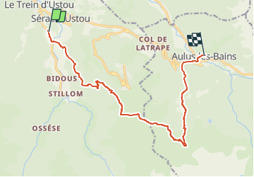
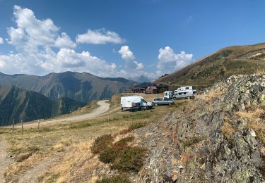
Tocht Stappen van 14,8 km beschikbaar op Occitanië, Ariège, Ustou. Deze tocht wordt voorgesteld door JM Heine.
Beschrijving
Départ du gîte d'étape La Colline Verte à St Lizier d'Ustou.
650m après la cascade de Fouillet, raccourci via 1 GRP
Arrivée : Résidence "Aux Volets bleus d'Aulus" : 06 77 24 10 23
Plaatsbepaling
Land:
France
Regio :
Occitanië
Departement/Provincie :
Ariège
Gemeente :
Ustou
Locatie:
Unknown
Vertrek:(Dec)
Vertrek:(UTM)
358010 ; 4740036 (31T) N.
Opmerkingen
Wandeltochten in de omgeving
![Tocht Stappen Ustou - Col de serre - Photo](https://media.geolcdn.com/t/375/260/9b0ff7ec-3f70-4e2e-a460-cdf6da735670.jpeg&format=jpg&maxdim=2)
![Stappen Stappen](https://static1.geolcdn.com/sitytour/trail-icons/101.png)
![Tocht Stappen Ustou - Le tour de la cabane d'Ardio - Photo](https://media.geolcdn.com/t/375/260/ext.jpg?maxdim=2&url=https%3A%2F%2Fservices.sitytrail.com%2FGeolivesWS%2FDownloadMedia.ashx%3FTrailID%3D109129%26Media%3D3169_1.jpg)
![Stappen Stappen](https://static1.geolcdn.com/sitytour/trail-icons/101.png)
Le tour de la cabane d'Ardio
Stappen
Medium
(1)
Ustou,
Occitanië,
Ariège,
France
![](/images/other/stat-length.png)
4,4 km | 7,1 km-effort
1h 30min
![](https://static1.geolcdn.com/siteimages/upload/files/16400158638029165_repeat_loop_refresh_sync_direction_icon.png)
Ja
![Tocht Stappen Ustou - Les Cascades du chemin d'Espagne - Photo](https://media.geolcdn.com/t/375/260/ext.jpg?maxdim=2&url=https%3A%2F%2Fservices.sitytrail.com%2FGeolivesWS%2FDownloadMedia.ashx%3FTrailID%3D109125%26Media%3D3166_1.jpg)
![Stappen Stappen](https://static1.geolcdn.com/sitytour/trail-icons/101.png)
Les Cascades du chemin d'Espagne
Stappen
Medium
(1)
Ustou,
Occitanië,
Ariège,
France
![](/images/other/stat-length.png)
8,1 km | 13,1 km-effort
2h 30min
![](https://static1.geolcdn.com/siteimages/upload/files/16400158638029165_repeat_loop_refresh_sync_direction_icon.png)
Ja
![Tocht Stappen Ustou - Alet lacarde - Photo](https://media.geolcdn.com/t/375/260/27892605-2437-41ef-be78-41576cffc567.jpg&format=jpg&maxdim=2)
![Stappen Stappen](https://static1.geolcdn.com/sitytour/trail-icons/101.png)
Alet lacarde
Stappen
Zeer moeilijk
Ustou,
Occitanië,
Ariège,
France
![](/images/other/stat-length.png)
13,3 km | 30 km-effort
6h 22min
![](https://static1.geolcdn.com/siteimages/upload/files/16400158638029165_repeat_loop_refresh_sync_direction_icon.png)
Ja
![Tocht Te voet Ustou - Le cirque de Cagateille - Photo](https://media.geolcdn.com/t/375/260/b85b23f9-0171-4dba-9255-58e8e46a4892.jpeg&format=jpg&maxdim=2)
![Te voet Te voet](https://static1.geolcdn.com/sitytour/trail-icons/100.png)
Le cirque de Cagateille
Te voet
Medium
Ustou,
Occitanië,
Ariège,
France
![](/images/other/stat-length.png)
11,1 km | 26 km-effort
5h 49min
![](https://static1.geolcdn.com/siteimages/upload/files/16400158638029165_repeat_loop_refresh_sync_direction_icon.png)
Ja
![Tocht Te voet Ustou - Pic de Couillac par le cirque de Cagateille - Photo](https://media.geolcdn.com/t/375/260/b85b23f9-0171-4dba-9255-58e8e46a4892.jpeg&format=jpg&maxdim=2)
![Te voet Te voet](https://static1.geolcdn.com/sitytour/trail-icons/100.png)
Pic de Couillac par le cirque de Cagateille
Te voet
Moeilijk
Ustou,
Occitanië,
Ariège,
France
![](/images/other/stat-length.png)
16,3 km | 39 km-effort
8h 52min
![](https://static1.geolcdn.com/siteimages/upload/files/16400158638029165_repeat_loop_refresh_sync_direction_icon.png)
Ja
![Tocht Stappen Ustou - Ustou - Photo](https://media.geolcdn.com/t/375/260/6a47a3e3-0a99-4be0-b03a-9e74ce0dfd69.jpg&format=jpg&maxdim=2)
![Stappen Stappen](https://static1.geolcdn.com/sitytour/trail-icons/101.png)
![Tocht Stappen Ustou - Cagateille - Certascan - Photo](https://media.geolcdn.com/t/375/260/1d9be698-3fc9-4fef-b6ba-8a2be6645e5c.jpeg&format=jpg&maxdim=2)
![Stappen Stappen](https://static1.geolcdn.com/sitytour/trail-icons/101.png)
Cagateille - Certascan
Stappen
Zeer moeilijk
Ustou,
Occitanië,
Ariège,
France
![](/images/other/stat-length.png)
10,4 km | 29 km-effort
8h 0min
![](https://static1.geolcdn.com/siteimages/upload/files/16400158638029165_repeat_loop_refresh_sync_direction_icon.png)
Neen
![Tocht Stappen Ustou - 2022 TRANSPYRÉNÉEN - St Lizier -d’Ustou -Aulus les Bains - Photo](https://media.geolcdn.com/t/375/260/fe127ba5-265b-4ae4-b883-31d9e39fedfd.jpg&format=jpg&maxdim=2)
![Stappen Stappen](https://static1.geolcdn.com/sitytour/trail-icons/101.png)
2022 TRANSPYRÉNÉEN - St Lizier -d’Ustou -Aulus les Bains
Stappen
Zeer moeilijk
Ustou,
Occitanië,
Ariège,
France
![](/images/other/stat-length.png)
17,5 km | 33 km-effort
4h 40min
![](https://static1.geolcdn.com/siteimages/upload/files/16400158638029165_repeat_loop_refresh_sync_direction_icon.png)
Neen