![](/images/other/stat-length.png)
![Tocht Stappen Emmerin - Des Bois, des Voies et des Champs - Photo](https://media.geolcdn.com/t/1900/400/ext.pjpeg?maxdim=2&url=https%3A%2F%2Fstatic1.geolcdn.com%2Fsiteimages%2Fupload%2Ffiles%2F1553511878bg_sport_marche.png)
Des Bois, des Voies et des Champs
jeandelanappe
Gebruiker
![Lengte](/images/other/stat-length.png)
Lengte
9,9 km
![Max. hoogte](https://static1.geolcdn.com/siteimages/upload/files/1508320355ic_sort_altitude_max_24dp.png)
Max. hoogte
30 m
![Positief hoogteverschil](https://static1.geolcdn.com/siteimages/upload/files/1508320355ic_sort_den_pos_24dp.png)
Positief hoogteverschil
53 m
![Km-Effort](/images/other/stat-length.png)
Km-Effort
10,6 km
![Min. hoogte](https://static1.geolcdn.com/siteimages/upload/files/1508320355ic_sort_altitude_min_24dp.png)
Min. hoogte
16 m
![Negatief hoogteverschil](https://static1.geolcdn.com/siteimages/upload/files/1508320355ic_sort_den_neg_24dp.png)
Negatief hoogteverschil
53 m
![Boucle](https://static1.geolcdn.com/siteimages/upload/files/16400158638029165_repeat_loop_refresh_sync_direction_icon.png)
Boucle
Ja
Datum van aanmaak :
2022-04-20 08:20:16.554
Laatste wijziging :
2022-04-20 08:57:59.429
![Stappen](https://static1.geolcdn.com/sitytour/trail-icons/101.png)
1h35
Moeilijkheid : Medium
![Scan deze QR-code om de tocht te openen in de SityTrail-applicatie](https://capi.geolives.com/qq0zvz2zws4bq2lad0pu/sitytour/trails/3211554/qr.png?size=200)
Gratisgps-wandelapplicatie
Over ons
Tocht Stappen van 9,9 km beschikbaar op Hauts-de-France, Noorderdepartement, Emmerin. Deze tocht wordt voorgesteld door jeandelanappe.
Beschrijving
Départ du parking de l'église - Voie du val au moines - Vers le plat de Noyelles - Voie des chats puis Voie des messes - Envers de Mosaic - Retour par l'allée des longs tours - la Part d'eau - La ferme d'Anchin.
Plaatsbepaling
Land:
France
Regio :
Hauts-de-France
Departement/Provincie :
Noorderdepartement
Gemeente :
Emmerin
Locatie:
Unknown
Vertrek:(Dec)
Vertrek:(UTM)
500104 ; 5604544 (31U) N.
Opmerkingen
Wandeltochten in de omgeving
![Tocht Stappen Wattignies - Autour des champs captants (Wattignies) - Photo](https://media.geolcdn.com/t/375/260/ext.jpg?maxdim=2&url=https%3A%2F%2Fservices.sitytrail.com%2FGeolivesWS%2FDownloadMedia.ashx%3FTrailID%3D109322%26Media%3D3588_6.jpg)
![Stappen Stappen](https://static1.geolcdn.com/sitytour/trail-icons/101.png)
Autour des champs captants (Wattignies)
Stappen
Medium
(1)
Wattignies,
Hauts-de-France,
Noorderdepartement,
France
![](/images/other/stat-length.png)
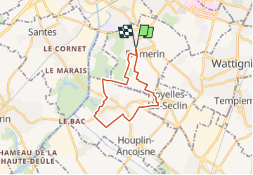
12,2 km | 13,1 km-effort
3h 15min
![](https://static1.geolcdn.com/siteimages/upload/files/16400158638029165_repeat_loop_refresh_sync_direction_icon.png)
Ja
![Stappen Stappen](https://static1.geolcdn.com/sitytour/trail-icons/101.png)
20230918 - TOTEMUS Lille - 5.4 Km
Stappen
Gemakkelijk
Rijsel,
Hauts-de-France,
Noorderdepartement,
France
![](/images/other/stat-length.png)
5,4 km | 5,8 km-effort
1h 28min
![](https://static1.geolcdn.com/siteimages/upload/files/16400158638029165_repeat_loop_refresh_sync_direction_icon.png)
Ja
![Tocht Stappen Rijsel - LILLE (court) - de la gare L. Flandres au Minimes - Photo](https://media.geolcdn.com/t/375/260/ext.jpg?maxdim=2&url=https%3A%2F%2Fstatic1.geolcdn.com%2Fsiteimages%2Fupload%2Ffiles%2F1553511878bg_sport_marche.png)
![Stappen Stappen](https://static1.geolcdn.com/sitytour/trail-icons/101.png)
LILLE (court) - de la gare L. Flandres au Minimes
Stappen
Gemakkelijk
(1)
Rijsel,
Hauts-de-France,
Noorderdepartement,
France
![](/images/other/stat-length.png)
4,1 km | 4,6 km-effort
1h 2min
![](https://static1.geolcdn.com/siteimages/upload/files/16400158638029165_repeat_loop_refresh_sync_direction_icon.png)
Ja
![Tocht Stappen Rijsel - Lille rando des remparts 18 km - Photo](https://media.geolcdn.com/t/375/260/47f3105d-7eb3-4eed-9a9d-96927ffd6f80.jpg&format=jpg&maxdim=2)
![Stappen Stappen](https://static1.geolcdn.com/sitytour/trail-icons/101.png)
Lille rando des remparts 18 km
Stappen
Medium
Rijsel,
Hauts-de-France,
Noorderdepartement,
France
![](/images/other/stat-length.png)
20 km | 0 m-effort
5h 37min
![](https://static1.geolcdn.com/siteimages/upload/files/16400158638029165_repeat_loop_refresh_sync_direction_icon.png)
Ja
![Tocht Stappen Santes - santes - Photo](https://media.geolcdn.com/t/375/260/ext.jpg?maxdim=2&url=https%3A%2F%2Fstatic1.geolcdn.com%2Fsiteimages%2Fupload%2Ffiles%2F1553511878bg_sport_marche.png)
![Stappen Stappen](https://static1.geolcdn.com/sitytour/trail-icons/101.png)
santes
Stappen
Heel gemakkelijk
(1)
Santes,
Hauts-de-France,
Noorderdepartement,
France
![](/images/other/stat-length.png)
4,6 km | 5,1 km-effort
1h 7min
![](https://static1.geolcdn.com/siteimages/upload/files/16400158638029165_repeat_loop_refresh_sync_direction_icon.png)
Neen
![Tocht Stappen Santes - SANTES 2024 - SLCP - Photo](https://media.geolcdn.com/t/375/260/a11ce7ac-360b-4a28-aab8-b10fc449f75e.jpg&format=jpg&maxdim=2)
![Stappen Stappen](https://static1.geolcdn.com/sitytour/trail-icons/101.png)
SANTES 2024 - SLCP
Stappen
Medium
Santes,
Hauts-de-France,
Noorderdepartement,
France
![](/images/other/stat-length.png)
7,2 km | 7,7 km-effort
1h 59min
![](https://static1.geolcdn.com/siteimages/upload/files/16400158638029165_repeat_loop_refresh_sync_direction_icon.png)
Ja
![Tocht Te voet Rijsel - circuit des Remparts lille - Photo](https://media.geolcdn.com/t/375/260/6f075244-2aca-46ce-a42c-e7da0adb0602.jpg&format=jpg&maxdim=2)
![Te voet Te voet](https://static1.geolcdn.com/sitytour/trail-icons/100.png)
circuit des Remparts lille
Te voet
Gemakkelijk
Rijsel,
Hauts-de-France,
Noorderdepartement,
France
![](/images/other/stat-length.png)
17,3 km | 19,4 km-effort
4h 24min
![](https://static1.geolcdn.com/siteimages/upload/files/16400158638029165_repeat_loop_refresh_sync_direction_icon.png)
Ja
![Tocht Stappen Seclin - seclin bis 12,5 km - Photo](https://media.geolcdn.com/t/375/260/ext.jpg?maxdim=2&url=https%3A%2F%2Fservices.sitytrail.com%2FGeolivesWS%2FDownloadMedia.ashx%3FTrailID%3D925110%26Media%3D20180318122358.jpg)
![Stappen Stappen](https://static1.geolcdn.com/sitytour/trail-icons/101.png)
seclin bis 12,5 km
Stappen
Heel gemakkelijk
Seclin,
Hauts-de-France,
Noorderdepartement,
France
![](/images/other/stat-length.png)
12,7 km | 13,5 km-effort
3h 47min
![](https://static1.geolcdn.com/siteimages/upload/files/16400158638029165_repeat_loop_refresh_sync_direction_icon.png)
Ja
![Tocht Mountainbike Hallennes-lez-Haubourdin - Haubourdin - Beaucamps - Photo](https://media.geolcdn.com/t/375/260/ext.jpg?maxdim=2&url=https%3A%2F%2Fservices.sitytrail.com%2FGeolivesWS%2FDownloadMedia.ashx%3FTrailID%3D814535%26Media%3D20170821152637.jpg)
![Mountainbike Mountainbike](https://static1.geolcdn.com/sitytour/trail-icons/202.png)
Haubourdin - Beaucamps
Mountainbike
Medium
Hallennes-lez-Haubourdin,
Hauts-de-France,
Noorderdepartement,
France
![](/images/other/stat-length.png)
26 km | 27 km-effort
1h 39min
![](https://static1.geolcdn.com/siteimages/upload/files/16400158638029165_repeat_loop_refresh_sync_direction_icon.png)
Ja