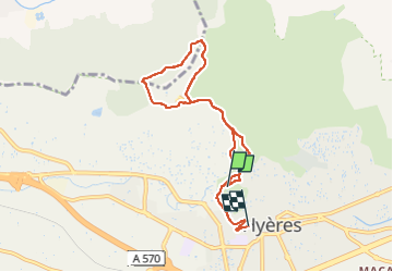
![](/images/other/stat-length.png)
![Tocht Stappen Hyères - hyeres les maurettes - Photo](https://media.geolcdn.com/t/1900/400/ext.pjpeg?maxdim=2&url=https%3A%2F%2Fmedia.geolcdn.com%2Ff%2F94a9b8bc-4cbf-43be-a95c-d8b262efea22.jpg)
hyeres les maurettes
marchev
Gebruiker
![Lengte](/images/other/stat-length.png)
Lengte
7,7 km
![Max. hoogte](https://static1.geolcdn.com/siteimages/upload/files/1508320355ic_sort_altitude_max_24dp.png)
Max. hoogte
188 m
![Positief hoogteverschil](https://static1.geolcdn.com/siteimages/upload/files/1508320355ic_sort_den_pos_24dp.png)
Positief hoogteverschil
154 m
![Km-Effort](/images/other/stat-length.png)
Km-Effort
10 km
![Min. hoogte](https://static1.geolcdn.com/siteimages/upload/files/1508320355ic_sort_altitude_min_24dp.png)
Min. hoogte
46 m
![Negatief hoogteverschil](https://static1.geolcdn.com/siteimages/upload/files/1508320355ic_sort_den_neg_24dp.png)
Negatief hoogteverschil
234 m
![Boucle](https://static1.geolcdn.com/siteimages/upload/files/16400158638029165_repeat_loop_refresh_sync_direction_icon.png)
Boucle
Neen
Datum van aanmaak :
2022-04-17 13:21:31.925
Laatste wijziging :
2022-04-18 04:14:16.053
![Stappen](https://static1.geolcdn.com/sitytour/trail-icons/101.png)
2h36
Moeilijkheid : Gemakkelijk
![Scan deze QR-code om de tocht te openen in de SityTrail-applicatie](https://capi.geolives.com/qq0zvz2zws4bq2lad0pu/sitytour/trails/3208383/qr.png?size=200)
Gratisgps-wandelapplicatie
Over ons
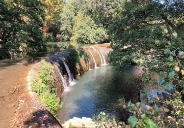
Tocht Stappen van 7,7 km beschikbaar op Provence-Alpes-Côte d'Azur, Var, Hyères. Deze tocht wordt voorgesteld door marchev.
Beschrijving
manque le début de la randonnée Départ Avenues des iles d'or.
Prendre le passage Saint Croix à côté de l'immeuble au20 avenue des ïles d'or.Puis montée st croix. Tourner à gauche pour la rue Victor Bach. Puis montée du chemin de la Porte Saint Jean et début randonnée.
Plaatsbepaling
Land:
France
Regio :
Provence-Alpes-Côte d'Azur
Departement/Provincie :
Var
Gemeente :
Hyères
Locatie:
Unknown
Vertrek:(Dec)
Vertrek:(UTM)
265982 ; 4778675 (32T) N.
Opmerkingen
Wandeltochten in de omgeving
![Tocht Stappen La Crau - fenouillet Daniel Louis - Photo](https://media.geolcdn.com/t/375/260/ext.jpg?maxdim=2&url=https%3A%2F%2Fmedia.geolcdn.com%2Ff%2F74a8e577-0c5f-4f83-9925-bb595eab64a1.jpg)
![Stappen Stappen](https://static1.geolcdn.com/sitytour/trail-icons/101.png)
fenouillet Daniel Louis
Stappen
Medium
(1)
La Crau,
Provence-Alpes-Côte d'Azur,
Var,
France
![](/images/other/stat-length.png)
18,1 km | 25 km-effort
4h 36min
![](https://static1.geolcdn.com/siteimages/upload/files/16400158638029165_repeat_loop_refresh_sync_direction_icon.png)
Ja
![Tocht Stappen La Crau - le fenouillet un après-midi d'automne - Photo](https://media.geolcdn.com/t/375/260/ext.jpg?maxdim=2&url=https%3A%2F%2Fservices.sitytrail.com%2FGeolivesWS%2FDownloadMedia.ashx%3FTrailID%3D650501%26Media%3D20161024161101.jpg)
![Stappen Stappen](https://static1.geolcdn.com/sitytour/trail-icons/101.png)
le fenouillet un après-midi d'automne
Stappen
Gemakkelijk
(2)
La Crau,
Provence-Alpes-Côte d'Azur,
Var,
France
![](/images/other/stat-length.png)
7,6 km | 10,7 km-effort
1h 48min
![](https://static1.geolcdn.com/siteimages/upload/files/16400158638029165_repeat_loop_refresh_sync_direction_icon.png)
Ja
![Tocht Stappen La Crau - Fenouillet - Chateau de Hyères - retour par les vignes - Photo](https://media.geolcdn.com/t/375/260/ext.jpg?maxdim=2&url=https%3A%2F%2Fmedia.geolcdn.com%2Ff%2Fd2132167-a625-4ff2-ae44-a142bdaeb4e4.jpg)
![Stappen Stappen](https://static1.geolcdn.com/sitytour/trail-icons/101.png)
Fenouillet - Chateau de Hyères - retour par les vignes
Stappen
Medium
(2)
La Crau,
Provence-Alpes-Côte d'Azur,
Var,
France
![](/images/other/stat-length.png)
14,1 km | 19,7 km-effort
5h 0min
![](https://static1.geolcdn.com/siteimages/upload/files/16400158638029165_repeat_loop_refresh_sync_direction_icon.png)
Ja
![Tocht Stappen Solliès-Ville - Domaine de la Castille- Solliès-Pont-08-09-23 - Photo](https://media.geolcdn.com/t/375/260/ext.jpg?maxdim=2&url=https%3A%2F%2Fmedia.geolcdn.com%2Ff%2F252af893-9283-4684-96a0-b5a46e961400.jpg)
![Stappen Stappen](https://static1.geolcdn.com/sitytour/trail-icons/101.png)
Domaine de la Castille- Solliès-Pont-08-09-23
Stappen
Gemakkelijk
Solliès-Ville,
Provence-Alpes-Côte d'Azur,
Var,
France
![](/images/other/stat-length.png)
6,8 km | 7,7 km-effort
2h 30min
![](https://static1.geolcdn.com/siteimages/upload/files/16400158638029165_repeat_loop_refresh_sync_direction_icon.png)
Ja
![Tocht Stappen La Crau - fenouillet plan du pont - Photo](https://media.geolcdn.com/t/375/260/ext.jpg?maxdim=2&url=https%3A%2F%2Fmedia.geolcdn.com%2Ff%2Fb7ab377c-6bf0-4fec-8a5c-2b318085c2ea.jpg)
![Stappen Stappen](https://static1.geolcdn.com/sitytour/trail-icons/101.png)
fenouillet plan du pont
Stappen
Zeer moeilijk
La Crau,
Provence-Alpes-Côte d'Azur,
Var,
France
![](/images/other/stat-length.png)
16,2 km | 24 km-effort
5h 24min
![](https://static1.geolcdn.com/siteimages/upload/files/16400158638029165_repeat_loop_refresh_sync_direction_icon.png)
Ja
![Tocht Stappen Carqueiranne - la grotte du paradis - Photo](https://media.geolcdn.com/t/375/260/ext.jpg?maxdim=2&url=https%3A%2F%2Fmedia.geolcdn.com%2Ff%2F9486f261-69b8-4de0-9e87-579eb1d901e8.jpg)
![Stappen Stappen](https://static1.geolcdn.com/sitytour/trail-icons/101.png)
la grotte du paradis
Stappen
Gemakkelijk
Carqueiranne,
Provence-Alpes-Côte d'Azur,
Var,
France
![](/images/other/stat-length.png)
3,9 km | 6,6 km-effort
1h 35min
![](https://static1.geolcdn.com/siteimages/upload/files/16400158638029165_repeat_loop_refresh_sync_direction_icon.png)
Ja
![Tocht Stappen Hyères - Ayguade plage port - Photo](https://media.geolcdn.com/t/375/260/ext.jpg?maxdim=2&url=https%3A%2F%2Fmedia.geolcdn.com%2Ff%2F3ac04e3d-5394-4469-8ff5-f2d403ceda96.jpg)
![Stappen Stappen](https://static1.geolcdn.com/sitytour/trail-icons/101.png)
Ayguade plage port
Stappen
Gemakkelijk
Hyères,
Provence-Alpes-Côte d'Azur,
Var,
France
![](/images/other/stat-length.png)
13,4 km | 14,7 km-effort
2h 32min
![](https://static1.geolcdn.com/siteimages/upload/files/16400158638029165_repeat_loop_refresh_sync_direction_icon.png)
Ja
![Tocht Trail La Crau - Le Fenouillet et château d' Hyères - Photo](https://media.geolcdn.com/t/375/260/ext.jpg?maxdim=2&url=https%3A%2F%2Fmedia.geolcdn.com%2Ff%2Fb5c97bc5-16a4-4fca-8ec6-5ff57c47ff40.jpg)
![Trail Trail](https://static1.geolcdn.com/sitytour/trail-icons/104.png)
Le Fenouillet et château d' Hyères
Trail
Medium
La Crau,
Provence-Alpes-Côte d'Azur,
Var,
France
![](/images/other/stat-length.png)
13,1 km | 18,8 km-effort
2h 9min
![](https://static1.geolcdn.com/siteimages/upload/files/16400158638029165_repeat_loop_refresh_sync_direction_icon.png)
Neen
![Tocht Stappen La Crau - château d Hyères-16-09-22 - Photo](https://media.geolcdn.com/t/375/260/ext.jpg?maxdim=2&url=https%3A%2F%2Fmedia.geolcdn.com%2Ff%2F3a88911b-3af6-4a76-9884-29b2386c32d9.jpg)
![Stappen Stappen](https://static1.geolcdn.com/sitytour/trail-icons/101.png)
château d Hyères-16-09-22
Stappen
Medium
La Crau,
Provence-Alpes-Côte d'Azur,
Var,
France
![](/images/other/stat-length.png)
13,3 km | 19,6 km-effort
3h 41min
![](https://static1.geolcdn.com/siteimages/upload/files/16400158638029165_repeat_loop_refresh_sync_direction_icon.png)
Ja