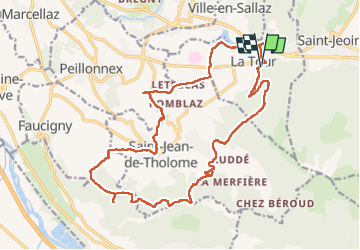
![](/images/other/stat-length.png)
![Tocht Stappen La Tour - 17-04-2022 Le tour de Saint Jean de Tholomé - Photo](https://media.geolcdn.com/t/1900/400/afe0a2c8-09a9-438d-add3-0f8a286a78fb.jpg&format=pjpeg&maxdim=2)
17-04-2022 Le tour de Saint Jean de Tholomé
Kargil
Gebruiker GUIDE
![Lengte](/images/other/stat-length.png)
![Max. hoogte](https://static1.geolcdn.com/siteimages/upload/files/1508320355ic_sort_altitude_max_24dp.png)
![Positief hoogteverschil](https://static1.geolcdn.com/siteimages/upload/files/1508320355ic_sort_den_pos_24dp.png)
![Km-Effort](/images/other/stat-length.png)
![Min. hoogte](https://static1.geolcdn.com/siteimages/upload/files/1508320355ic_sort_altitude_min_24dp.png)
![Negatief hoogteverschil](https://static1.geolcdn.com/siteimages/upload/files/1508320355ic_sort_den_neg_24dp.png)
![Boucle](https://static1.geolcdn.com/siteimages/upload/files/16400158638029165_repeat_loop_refresh_sync_direction_icon.png)
![Stappen](https://static1.geolcdn.com/sitytour/trail-icons/101.png)
5h19
Moeilijkheid : Moeilijk
![Scan deze QR-code om de tocht te openen in de SityTrail-applicatie](https://capi.geolives.com/qq0zvz2zws4bq2lad0pu/sitytour/trails/3208217/qr.png?size=200)
Gratisgps-wandelapplicatie
Over ons
Tocht Stappen van 21 km beschikbaar op Auvergne-Rhône-Alpes, Haute-Savoie, La Tour. Deze tocht wordt voorgesteld door Kargil.
Beschrijving
Les moins :
-Un premier tiers sur routes de campagne goudronnées avec peu de passage et majoritairement possibilité de marcher sur le bas côté en herbe.
-Des travaux forestiers ont largement modifiés la cartographie
Les plus :
-Une distance non négligeable avec un dénivelé correct
-De belles vues de Alpes à Jura puis Jura à Alpes
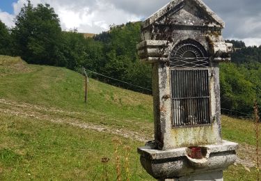
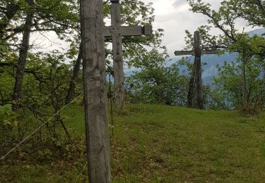
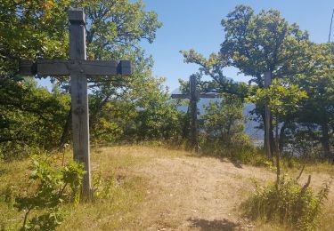
-Des lieux remarquables comme le chemin de croix d'Orgevat
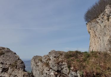
-Des travaux forestiers qui ont permis un itinéraire hors sentier (sur l'arrête du Dard et au Chargieux)
Le sentier pointillé à gauche du point 1048 n'existe plus. La descente se fait en ligne droite dans une belle pente.
Un détour par Le Grand Château depuis le Reray (il suffit de continuer tout droit) peut constituer un beau bonus.
Plaatsbepaling
Opmerkingen
Wandeltochten in de omgeving
![Tocht Stappen Viuz-en-Sallaz - Viuz-Les Brasses-Vernant-Viuz - Photo](https://media.geolcdn.com/t/375/260/34dcd57e-15ca-4ca3-ab02-fc2bad27ee19.jpg&format=jpg&maxdim=2)
![Stappen Stappen](https://static1.geolcdn.com/sitytour/trail-icons/101.png)
Stappen
![](/images/other/stat-length.png)
![](https://static1.geolcdn.com/siteimages/upload/files/16400158638029165_repeat_loop_refresh_sync_direction_icon.png)
![Tocht Stappen Bonneville - Tour du Reyret - Photo](https://media.geolcdn.com/t/375/260/3a92c894-f22c-4988-83b1-a50c7d0d14a4.jpg&format=jpg&maxdim=2)
![Stappen Stappen](https://static1.geolcdn.com/sitytour/trail-icons/101.png)
Stappen
![](/images/other/stat-length.png)
![](https://static1.geolcdn.com/siteimages/upload/files/16400158638029165_repeat_loop_refresh_sync_direction_icon.png)
![Tocht Stappen Ayse - Les Gallinons - Crêtes du Rocher de l'aigle - Les Gallinons - Photo](https://media.geolcdn.com/t/375/260/a639a28d-0ec8-43bc-b5eb-0bc044c3bd96.jpg&format=jpg&maxdim=2)
![Stappen Stappen](https://static1.geolcdn.com/sitytour/trail-icons/101.png)
Stappen
![](/images/other/stat-length.png)
![](https://static1.geolcdn.com/siteimages/upload/files/16400158638029165_repeat_loop_refresh_sync_direction_icon.png)
![Tocht Stappen Bonneville - Chemin de Croix d'Orgevat par Le Reyret - Photo](https://media.geolcdn.com/t/375/260/e982347c-b249-4c2e-8b5c-da3bb77412db.jpg&format=jpg&maxdim=2)
![Stappen Stappen](https://static1.geolcdn.com/sitytour/trail-icons/101.png)
Stappen
![](/images/other/stat-length.png)
![](https://static1.geolcdn.com/siteimages/upload/files/16400158638029165_repeat_loop_refresh_sync_direction_icon.png)
![Tocht Stappen Ville-en-Sallaz - 2020-07 Lac du Môle - Saint Jeoire - Photo](https://media.geolcdn.com/t/375/260/4ade7828-b272-4802-b721-df9a5ba1cac5.jpg&format=jpg&maxdim=2)
![Stappen Stappen](https://static1.geolcdn.com/sitytour/trail-icons/101.png)
Stappen
![](/images/other/stat-length.png)
![](https://static1.geolcdn.com/siteimages/upload/files/16400158638029165_repeat_loop_refresh_sync_direction_icon.png)
![Tocht Stappen Marignier - Le Môle par l'arrête Nord. - Photo](https://media.geolcdn.com/t/375/260/ext.jpg?maxdim=2&url=https%3A%2F%2Fservices.sitytrail.com%2FGeolivesWS%2FDownloadMedia.ashx%3FTrailID%3D774253%26Media%3Dfix__20170615160659.jpg)
![Stappen Stappen](https://static1.geolcdn.com/sitytour/trail-icons/101.png)
Stappen
![](/images/other/stat-length.png)
![](https://static1.geolcdn.com/siteimages/upload/files/16400158638029165_repeat_loop_refresh_sync_direction_icon.png)
![Tocht Stappen Marignier - Le Môle par l'arrête Nord. - Photo](https://media.geolcdn.com/t/375/260/ext.jpg?maxdim=2&url=https%3A%2F%2Fservices.sitytrail.com%2FGeolivesWS%2FDownloadMedia.ashx%3FTrailID%3D773609%26Media%3Dfix__20170615160659.jpg)
![Stappen Stappen](https://static1.geolcdn.com/sitytour/trail-icons/101.png)
Stappen
![](/images/other/stat-length.png)
![](https://static1.geolcdn.com/siteimages/upload/files/16400158638029165_repeat_loop_refresh_sync_direction_icon.png)
![Tocht Mountainbike Peillonnex - Crêtes de Vouan Ludran descente Foron de Viuz - Photo](https://media.geolcdn.com/t/375/260/ext.jpg?maxdim=2&url=https%3A%2F%2Fstatic1.geolcdn.com%2Fsiteimages%2Fupload%2Ffiles%2F1524743154velo.jpg)
![Mountainbike Mountainbike](https://static1.geolcdn.com/sitytour/trail-icons/202.png)
Mountainbike
![](/images/other/stat-length.png)
![](https://static1.geolcdn.com/siteimages/upload/files/16400158638029165_repeat_loop_refresh_sync_direction_icon.png)
![Tocht Lopen Saint-Jean-de-Tholome - Sortie Longue GR1 - 17/04 - Photo](https://media.geolcdn.com/t/375/260/ext.jpg?maxdim=2&url=https%3A%2F%2Fstatic1.geolcdn.com%2Fsiteimages%2Fupload%2Ffiles%2F1524743154running.jpg)
![Lopen Lopen](https://static1.geolcdn.com/sitytour/trail-icons/103.png)
Lopen
![](/images/other/stat-length.png)
![](https://static1.geolcdn.com/siteimages/upload/files/16400158638029165_repeat_loop_refresh_sync_direction_icon.png)