


 - Photo 21")
 - Photo 22")
 - Photo 23")
 - Photo 24")
 - Photo 25")
 - Photo 26")
 - Photo 27")
 - Photo 28")
 - Photo 29")
 - Photo 30")
 - Photo 31")
 - Photo 32")
 - Photo 33")
 - Photo 34")
 - Photo 35")
 - Photo 36")
 - Photo 37")
 - Photo 38")
 - Photo 39")
 - Photo 40")
 - Photo 41")
 - Photo 42")
 - Photo 43")
 - Photo 44")
 - Photo 45")
 - Photo 46")
 - Photo 47")
 - Photo 48")
 - Photo 49")
 - Photo 50")
 - Photo 51")
 - Photo 52")
 - Photo 53")
 - Photo 54")
 - Photo 55")
 - Photo 56")
 - Photo 57")
 - Photo 58")
 - Photo 59")
 - Photo 60")
 - Photo 61")
 - Photo 62")
 - Photo 63")
 - Photo 64")
 - Photo 65")
 - Photo 66")
 - Photo 67")
 - Photo 68")
 - Photo 69")
 - Photo 70")
 - Photo 71")
 - Photo 72")
 - Photo 73")


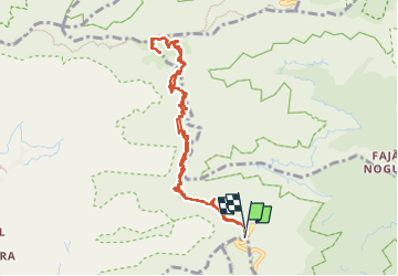
8 km | 14,2 km-effort

Gebruiker


Gratisgps-wandelapplicatie
 SityTrail
IGN / Geografische instituten
SityTrail World
De wereld gaat voor u open
Tocht Stappen van 12,3 km beschikbaar op Madeira, Onbekend, Monte. Deze tocht wordt voorgesteld door Bart2015.
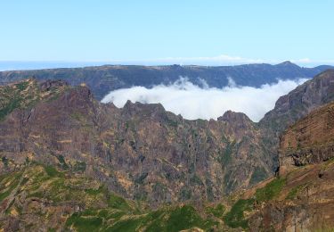
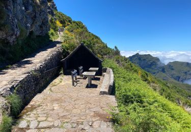
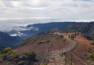
Très belle randonnée à faire si vous avez une bonne condition physique et si le sommet est dégagé. Il est indispensable de se lever tôt car les nuages recouvrent très souvent le sommet à partir de midi. Nous avons suivi le même chemin pour l'aller et le retour mais une variante existe. Des tunnels sont à traverser : frontale indispensable. Les chaussures montantes sont toujours conseillées. Profitez bien de toutes les magnifiques vues et vous verrez sûrement la perdrix rouge de Madère.
Bonne rando ...
 - Photo 1")
 - Photo 2")
 - Photo 3")
 - Photo 4")
 - Photo 5")
 - Photo 6")
 - Photo 7")
 - Photo 8")
 - Photo 9")
 - Photo 10")
 - Photo 11")
 - Photo 12")
 - Photo 13")
 - Photo 14")
 - Photo 15")
 - Photo 16")
 - Photo 17")
 - Photo 18")
 - Photo 19")
 - Photo 20")
73 fotos in totaal. Klik op een foto om ze allemaal in de galerij weer te geven.

Stappen
Te voet
Stappen
Stappen
Stappen
Stappen
Te voet
Stappen
Stappen