![](/images/other/stat-length.png)
![Tocht Mountainbike Clelles - Celles et alentours - Photo](https://media.geolcdn.com/t/1900/400/ext.pjpeg?maxdim=2&url=https%3A%2F%2Fstatic1.geolcdn.com%2Fsiteimages%2Fupload%2Ffiles%2F1524743154velo.jpg)
Celles et alentours
ChristianNILE
Gebruiker
![Lengte](/images/other/stat-length.png)
Lengte
41 km
![Max. hoogte](https://static1.geolcdn.com/siteimages/upload/files/1508320355ic_sort_altitude_max_24dp.png)
Max. hoogte
1338 m
![Positief hoogteverschil](https://static1.geolcdn.com/siteimages/upload/files/1508320355ic_sort_den_pos_24dp.png)
Positief hoogteverschil
1209 m
![Km-Effort](/images/other/stat-length.png)
Km-Effort
58 km
![Min. hoogte](https://static1.geolcdn.com/siteimages/upload/files/1508320355ic_sort_altitude_min_24dp.png)
Min. hoogte
629 m
![Negatief hoogteverschil](https://static1.geolcdn.com/siteimages/upload/files/1508320355ic_sort_den_neg_24dp.png)
Negatief hoogteverschil
1218 m
![Boucle](https://static1.geolcdn.com/siteimages/upload/files/16400158638029165_repeat_loop_refresh_sync_direction_icon.png)
Boucle
Ja
Datum van aanmaak :
2022-04-05 11:51:36.12
Laatste wijziging :
2022-04-05 18:14:14.902
![Mountainbike](https://static1.geolcdn.com/sitytour/trail-icons/202.png)
6h22
Moeilijkheid : Moeilijk
![Scan deze QR-code om de tocht te openen in de SityTrail-applicatie](https://capi.geolives.com/qq0zvz2zws4bq2lad0pu/sitytour/trails/3193817/qr.png?size=200)
Gratisgps-wandelapplicatie
Over ons
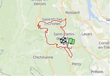
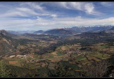
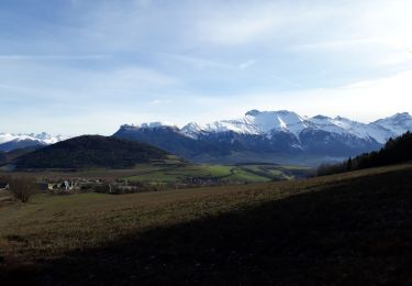
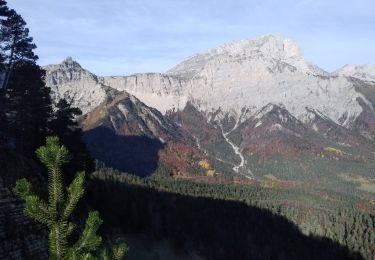
Tocht Mountainbike van 41 km beschikbaar op Auvergne-Rhône-Alpes, Isère, Clelles. Deze tocht wordt voorgesteld door ChristianNILE.
Beschrijving
Très belle randonnée très variée avec tantôt das passages techniques et des fortes montées. Tantôt des chemins vallonnés. Oubliez les aller-retour autour du village.
Plaatsbepaling
Land:
France
Regio :
Auvergne-Rhône-Alpes
Departement/Provincie :
Isère
Gemeente :
Clelles
Locatie:
Unknown
Vertrek:(Dec)
Vertrek:(UTM)
707788 ; 4967008 (31T) N.
Opmerkingen
Wandeltochten in de omgeving
![Tocht Stappen Chichilianne - Le Platary - Photo](https://media.geolcdn.com/t/375/260/ext.jpg?maxdim=2&url=https%3A%2F%2Fservices.sitytrail.com%2FGeolivesWS%2FDownloadMedia.ashx%3FTrailID%3D836793%26Media%3Dfix__20170928142121.jpg)
![Stappen Stappen](https://static1.geolcdn.com/sitytour/trail-icons/101.png)
Le Platary
Stappen
Medium
(2)
Chichilianne,
Auvergne-Rhône-Alpes,
Isère,
France
![](/images/other/stat-length.png)
6,6 km | 12,1 km-effort
2h 29min
![](https://static1.geolcdn.com/siteimages/upload/files/16400158638029165_repeat_loop_refresh_sync_direction_icon.png)
Ja
![Tocht Stappen Chichilianne - La Fontaine Pourrie - Hauts Plateaux Sud du Vercors - Photo](https://media.geolcdn.com/t/375/260/ext.jpg?maxdim=2&url=https%3A%2F%2Fservices.sitytrail.com%2FGeolivesWS%2FDownloadMedia.ashx%3FTrailID%3D105613%26Media%3D9383_1.jpg)
![Stappen Stappen](https://static1.geolcdn.com/sitytour/trail-icons/101.png)
La Fontaine Pourrie - Hauts Plateaux Sud du Vercors
Stappen
Medium
(2)
Chichilianne,
Auvergne-Rhône-Alpes,
Isère,
France
![](/images/other/stat-length.png)
19,4 km | 33 km-effort
7h 45min
![](https://static1.geolcdn.com/siteimages/upload/files/16400158638029165_repeat_loop_refresh_sync_direction_icon.png)
Ja
![Tocht Sneeuwschoenen Chichilianne - chichilianne archiane - Photo](https://media.geolcdn.com/t/375/260/ext.jpg?maxdim=2&url=https%3A%2F%2Fstatic1.geolcdn.com%2Fsiteimages%2Fupload%2Ffiles%2F1524743153raquette.jpg)
![Sneeuwschoenen Sneeuwschoenen](https://static1.geolcdn.com/sitytour/trail-icons/504.png)
chichilianne archiane
Sneeuwschoenen
Medium
(1)
Chichilianne,
Auvergne-Rhône-Alpes,
Isère,
France
![](/images/other/stat-length.png)
18,9 km | 32 km-effort
8h 0min
![](https://static1.geolcdn.com/siteimages/upload/files/16400158638029165_repeat_loop_refresh_sync_direction_icon.png)
Neen
![Tocht Stappen Saint-Martin-de-Clelles - Esclops Trièves tour du goutaroux - Photo](https://media.geolcdn.com/t/375/260/92348273-d153-4731-a4d8-1976f500b0d9.jpg&format=jpg&maxdim=2)
![Stappen Stappen](https://static1.geolcdn.com/sitytour/trail-icons/101.png)
Esclops Trièves tour du goutaroux
Stappen
Medium
Saint-Martin-de-Clelles,
Auvergne-Rhône-Alpes,
Isère,
France
![](/images/other/stat-length.png)
11 km | 18,8 km-effort
4h 58min
![](https://static1.geolcdn.com/siteimages/upload/files/16400158638029165_repeat_loop_refresh_sync_direction_icon.png)
Ja
![Tocht Te voet Chichilianne - Pas de l'Aiguille - Photo](https://media.geolcdn.com/t/375/260/b17edeb4-7e8a-4950-864e-2edc454f1f7c.jpeg&format=jpg&maxdim=2)
![Te voet Te voet](https://static1.geolcdn.com/sitytour/trail-icons/100.png)
Pas de l'Aiguille
Te voet
Medium
Chichilianne,
Auvergne-Rhône-Alpes,
Isère,
France
![](/images/other/stat-length.png)
17,1 km | 29 km-effort
6h 39min
![](https://static1.geolcdn.com/siteimages/upload/files/16400158638029165_repeat_loop_refresh_sync_direction_icon.png)
Ja
![Tocht Te voet Saint-Martin-de-Clelles - Chemin du Goutaroux - Photo](https://media.geolcdn.com/t/375/260/9d096ac3-20e2-4285-a876-435f73018545.jpeg&format=jpg&maxdim=2)
![Te voet Te voet](https://static1.geolcdn.com/sitytour/trail-icons/100.png)
Chemin du Goutaroux
Te voet
Gemakkelijk
Saint-Martin-de-Clelles,
Auvergne-Rhône-Alpes,
Isère,
France
![](/images/other/stat-length.png)
4,2 km | 9,5 km-effort
2h 9min
![](https://static1.geolcdn.com/siteimages/upload/files/16400158638029165_repeat_loop_refresh_sync_direction_icon.png)
Neen
![Tocht Stappen Chichilianne - Sommets de Charbonnier & du Platary - Photo](https://media.geolcdn.com/t/375/260/cd6d993b-8f70-411d-9b8e-9424ee6be01c.jpg&format=jpg&maxdim=2)
![Stappen Stappen](https://static1.geolcdn.com/sitytour/trail-icons/101.png)
Sommets de Charbonnier & du Platary
Stappen
Medium
Chichilianne,
Auvergne-Rhône-Alpes,
Isère,
France
![](/images/other/stat-length.png)
12,1 km | 21 km-effort
5h 24min
![](https://static1.geolcdn.com/siteimages/upload/files/16400158638029165_repeat_loop_refresh_sync_direction_icon.png)
Ja
![Tocht Stappen Lavars - Serre de la Fayolle - Photo](https://media.geolcdn.com/t/375/260/95bdaed1-9210-48db-8488-a02aafbf5b89.jpg&format=jpg&maxdim=2)
![Stappen Stappen](https://static1.geolcdn.com/sitytour/trail-icons/101.png)
Serre de la Fayolle
Stappen
Medium
Lavars,
Auvergne-Rhône-Alpes,
Isère,
France
![](/images/other/stat-length.png)
13,3 km | 19,9 km-effort
5h 53min
![](https://static1.geolcdn.com/siteimages/upload/files/16400158638029165_repeat_loop_refresh_sync_direction_icon.png)
Ja
![Tocht Stappen Saint-Martin-de-Clelles - rocher de pansaret - Photo](https://media.geolcdn.com/t/375/260/079d9c91-3f50-4ca1-a320-11e4965327f4.jpg&format=jpg&maxdim=2)
![Stappen Stappen](https://static1.geolcdn.com/sitytour/trail-icons/101.png)
rocher de pansaret
Stappen
Medium
Saint-Martin-de-Clelles,
Auvergne-Rhône-Alpes,
Isère,
France
![](/images/other/stat-length.png)
9,5 km | 19,6 km-effort
4h 51min
![](https://static1.geolcdn.com/siteimages/upload/files/16400158638029165_repeat_loop_refresh_sync_direction_icon.png)
Ja