![](/images/other/stat-length.png)
![Tocht Stappen Calheta - Madère : de Rabaçal vers les 25 sources - Photo](https://media.geolcdn.com/t/1900/400/c0fcee6c-1b6e-44b1-aed5-efb4d40aa24c.jpg&format=pjpeg&maxdim=2)
Madère : de Rabaçal vers les 25 sources
Bart2015
Gebruiker
![Lengte](/images/other/stat-length.png)
![Max. hoogte](https://static1.geolcdn.com/siteimages/upload/files/1508320355ic_sort_altitude_max_24dp.png)
![Positief hoogteverschil](https://static1.geolcdn.com/siteimages/upload/files/1508320355ic_sort_den_pos_24dp.png)
![Km-Effort](/images/other/stat-length.png)
![Min. hoogte](https://static1.geolcdn.com/siteimages/upload/files/1508320355ic_sort_altitude_min_24dp.png)
![Negatief hoogteverschil](https://static1.geolcdn.com/siteimages/upload/files/1508320355ic_sort_den_neg_24dp.png)
![Boucle](https://static1.geolcdn.com/siteimages/upload/files/16400158638029165_repeat_loop_refresh_sync_direction_icon.png)
![Stappen](https://static1.geolcdn.com/sitytour/trail-icons/101.png)
3h18
Moeilijkheid : Medium
![Scan deze QR-code om de tocht te openen in de SityTrail-applicatie](https://capi.geolives.com/qq0zvz2zws4bq2lad0pu/sitytour/trails/3189308/qr.png?size=200)
Gratisgps-wandelapplicatie
Over ons
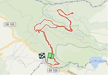
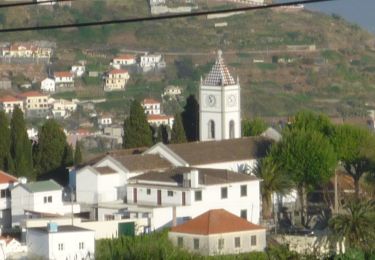
Tocht Stappen van 9,5 km beschikbaar op Madeira, Onbekend, Calheta. Deze tocht wordt voorgesteld door Bart2015.
Beschrijving
Randonnée très bien décrite dans le Rother Madère - n°51.
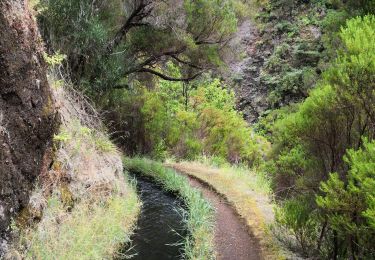
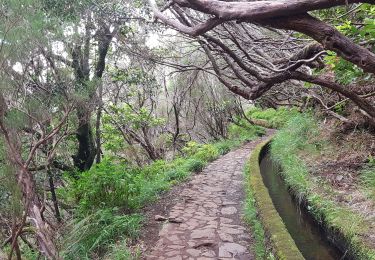
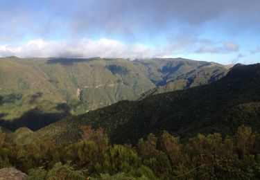
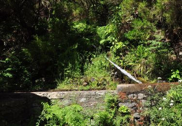
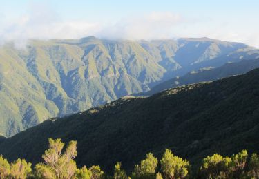
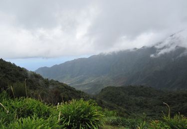
Très belle randonnée qui conduit à une magnifique cascade et ses 25 sources en longeant pour une bonne partie une levada ancienne au travers des gorges profondes de la Ribeira Grande. Physique pour la descente et la remontée, un minibus est en place pour descendre et/ou remonter du point de départ au bar de Rabaçal.
Bonne rando ...
Plaatsbepaling
Opmerkingen
Wandeltochten in de omgeving
![Tocht Stappen Calheta - chemin des cascades - Photo](https://media.geolcdn.com/t/375/260/c00528eb-97aa-45b4-9ff1-b112575f8736.jpg&format=jpg&maxdim=2)
![Stappen Stappen](https://static1.geolcdn.com/sitytour/trail-icons/101.png)
Stappen
![](/images/other/stat-length.png)
![](https://static1.geolcdn.com/siteimages/upload/files/16400158638029165_repeat_loop_refresh_sync_direction_icon.png)
![Tocht Andere activiteiten Calheta - levada 25 sources variante 13 km - Photo](https://media.geolcdn.com/t/375/260/ext.jpg?maxdim=2&url=https%3A%2F%2Fstatic1.geolcdn.com%2Fsiteimages%2Fupload%2Ffiles%2F1545311037marcheuse_200dpi.jpg)
![Andere activiteiten Andere activiteiten](https://static1.geolcdn.com/sitytour/trail-icons/900.png)
Andere activiteiten
![](/images/other/stat-length.png)
![](https://static1.geolcdn.com/siteimages/upload/files/16400158638029165_repeat_loop_refresh_sync_direction_icon.png)
![Tocht Stappen Arco da Calheta - Levada do 25 fontes - Photo](https://media.geolcdn.com/t/375/260/6039bf7b-1eb8-4247-b95e-55a7995178bd.jpg&format=jpg&maxdim=2)
![Stappen Stappen](https://static1.geolcdn.com/sitytour/trail-icons/101.png)
Stappen
![](/images/other/stat-length.png)
![](https://static1.geolcdn.com/siteimages/upload/files/16400158638029165_repeat_loop_refresh_sync_direction_icon.png)
![Tocht Te voet Ponta do Pargo - Vereda do Galhano - Photo](https://media.geolcdn.com/t/375/260/d5210e3e-3c5f-4efd-8d97-62e17b3ac8f4.jpeg&format=jpg&maxdim=2)
![Te voet Te voet](https://static1.geolcdn.com/sitytour/trail-icons/100.png)
Te voet
![](/images/other/stat-length.png)
![](https://static1.geolcdn.com/siteimages/upload/files/16400158638029165_repeat_loop_refresh_sync_direction_icon.png)
![Tocht Te voet Calheta - Vereda da Lagoa do Vento - Photo](https://media.geolcdn.com/t/375/260/759818e7-feb7-4f26-8e4c-72cd59be231e.jpeg&format=jpg&maxdim=2)
![Te voet Te voet](https://static1.geolcdn.com/sitytour/trail-icons/100.png)
Te voet
![](/images/other/stat-length.png)
![](https://static1.geolcdn.com/siteimages/upload/files/16400158638029165_repeat_loop_refresh_sync_direction_icon.png)
![Tocht Te voet Calheta - Levada do Alecrim - Photo](https://media.geolcdn.com/t/375/260/3dca4bbc-701e-47b5-afc8-fdf0d6c5f730.jpeg&format=jpg&maxdim=2)
![Te voet Te voet](https://static1.geolcdn.com/sitytour/trail-icons/100.png)
Te voet
![](/images/other/stat-length.png)
![](https://static1.geolcdn.com/siteimages/upload/files/16400158638029165_repeat_loop_refresh_sync_direction_icon.png)
![Tocht Te voet Arco da Calheta - Levada do Paul - Photo](https://media.geolcdn.com/t/375/260/8e21c2f2-cd7e-48f5-8ce7-57f2489de0d5.jpeg&format=jpg&maxdim=2)
![Te voet Te voet](https://static1.geolcdn.com/sitytour/trail-icons/100.png)
Te voet
![](/images/other/stat-length.png)
![](https://static1.geolcdn.com/siteimages/upload/files/16400158638029165_repeat_loop_refresh_sync_direction_icon.png)
![Tocht Te voet Calheta - Vereda do Lombo Barbinhas - Photo](https://media.geolcdn.com/t/375/260/db3e98f8-7ea7-41b7-b359-5ab0ad41297d.jpeg&format=jpg&maxdim=2)
![Te voet Te voet](https://static1.geolcdn.com/sitytour/trail-icons/100.png)
Te voet
![](/images/other/stat-length.png)
![](https://static1.geolcdn.com/siteimages/upload/files/16400158638029165_repeat_loop_refresh_sync_direction_icon.png)
![Tocht Te voet Ponta do Sol - Levada do Coronel - Photo](https://media.geolcdn.com/t/375/260/46fdaffc-82f7-458b-af4e-512906ebe29f.jpeg&format=jpg&maxdim=2)
![Te voet Te voet](https://static1.geolcdn.com/sitytour/trail-icons/100.png)
Te voet
![](/images/other/stat-length.png)
![](https://static1.geolcdn.com/siteimages/upload/files/16400158638029165_repeat_loop_refresh_sync_direction_icon.png)