Tocht Stappen Virton - Aux sources du Bruzel  -  Marche_11kms - Photo

Aux sources du Bruzel - Marche_11kms

 Pascal L
Pascal L

Gebruiker

© OpenStreetMap contributors
Lengte
Lengte
10,6 km
Max. hoogte
Max. hoogte
315 m
Positief hoogteverschil
169 m
Km-Effort
Km-Effort  
12,9 km
Min. hoogte
Min. hoogte
200 m
Negatief hoogteverschil
169 m
Boucle
Boucle
Ja
Datum van aanmaak :
2022-03-22 12:48:38.421
Laatste wijziging :
2022-12-12 13:48:28.616

(0 Bericht)

Stappen
Stappen
2h30
Moeilijkheid : Medium

Scan deze QR-code om de tocht te openen in de SityTrail-applicatie

Gratisgps-wandelapplicatie

Logo SityTrail SityTrail

IGN / Geografische instituten

SityTrail uit de App Store downloaden SityTrail uit Google Play downloaden

Logo SityTrail SityTrail World

De wereld gaat voor u open

SityTrail uit de App Store downloaden SityTrail uit Google Play downloaden SityTrail op Huawei AppGallery downloaden

Over ons

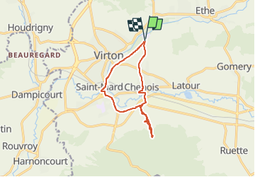
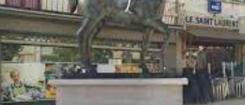
Tocht Stappen van 10,6 km beschikbaar op Wallonië, Luxemburg, Virton. Deze tocht wordt voorgesteld door Pascal L.

Beschrijving

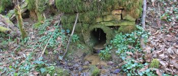
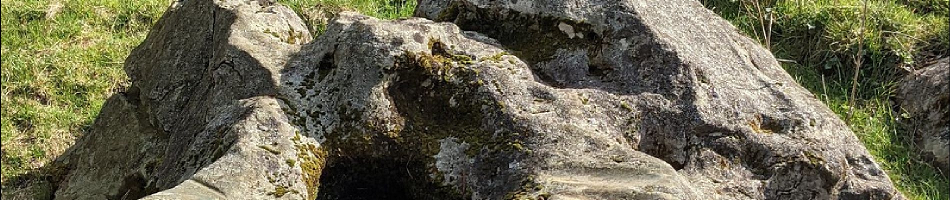
Cette marche vous conduit aux fameux "Polissoirs de Saint-Mard", en longeant le ruisseau Bruzel, jusqu'à sa source à une alt. de 315 m. Il s'agit de grosses pierres en grès silicieux situés sur la rive gauche du Bruzel (affluent de la Vire). Elles servaient à polir des outils en silex pendant la préhistoire. Les Saint-Mardois les appelaient aussi « les cailloux des sorcières » ou « les pierres aux fées ».
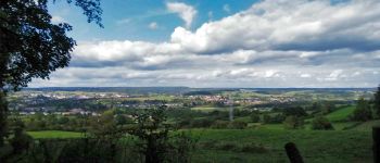
L'accès n'est malheureusement pas facile (en zone privée ou agricole). Il demande d'enjamber des clôtures (barbelés). Le panorama vaut aussi le déplacement.

Ref.
1. https://www.virton.be/loisirs/culture/breve-histoire-de-virton (site officiel de Virton)
2. https://www.luxembourg-belge.be/diffusio/fr/voir-faire/visiter/patrimoine-naturel/saint-mard/les-polissoirs-neolithiques-du-bruzel-et-pierre-aux-fees-cromlech_TFO12827.php
3. https://www.facebook.com/culture.virton.9/posts/1683669608334277/
4. https://m.megalithic.co.uk/article.php?sid=37911
5. https://biblio.naturalsciences.be/associated_publications/anthropologica-prehistorica/bulletin-de-la-societe-royale-belge-d-anthropologie-et-de-prehistoire/ap-047-1932/ap47_p383-p411.pdf
6. https://www.luxembourg-belge.be/diffusio/fr/p/decouverte-et-divertissement/les-polissoirs-neolithiques-du-bruzel-et-pierre-aux-fees-cromlech-virton_TFOLOD-01-0AVJ-6OCV/

(2022.03.22)

Hoogteprofiel

Foto's

74 fotos in totaal. Klik op een foto om ze allemaal in de galerij weer te geven.

POI's

POI Virton - Sources du Bruzel - Photo
Pascal L
POI Virton - Golf Découverte Virton - Photo
Pascal L
POI Virton - Moulin Naisse à Virton - Photo
Pascal L
POI Virton - Les étangs de Latour - Photo
Pascal L
POI Virton - Château de Latour - Photo
Pascal L

Plaatsbepaling

Land:
Belgium
Regio :
Wallonië
Departement/Provincie :
Luxemburg
Gemeente :
Virton
Locatie:
Unknown
Vertrek:(UTM)
684404 ; 5494249 (31U) N.

Wandeltochten in de omgeving

Tocht Stappen Virton - RB-Lu-17_Ethe_via-var-1-et-2-et-3 - Photo
Stappen
PRO

Stappen

Heel gemakkelijk
(3)
Virton, Wallonië, Luxemburg, Belgium
29 km | 35 km-effort
7h 33min
Ja
Tocht Mountainbike Virton - T2019-06-16-16-47 - Photo
Mountainbike
Pascal L

Mountainbike

Gemakkelijk
(1)
Virton, Wallonië, Luxemburg, Belgium
21 km | 26 km-effort
1h 40min
Ja
Tocht Stappen Virton - GAUME Balade  naturelle et historique - Photo
Stappen
julucasi

Stappen

Heel gemakkelijk
(1)
Virton, Wallonië, Luxemburg, Belgium
5,2 km | 6,8 km-effort
1h 16min
Ja
Tocht Te voet Virton - La Bajocienne - Photo
Te voet
GUIDE+

Te voet

Gemakkelijk
(1)
Virton, Wallonië, Luxemburg, Belgium
11 km | 14,5 km-effort
3h 17min
Ja
Tocht Stappen Virton - RB-Lu-17_Ethe_via-racc - Photo
Stappen
PRO

Stappen

Heel gemakkelijk
Virton, Wallonië, Luxemburg, Belgium
15,6 km | 19,3 km-effort
4h 8min
Ja
Tocht Stappen Virton - RB-Lu-17_Ethe - Photo
Stappen
PRO

Stappen

Heel gemakkelijk
Virton, Wallonië, Luxemburg, Belgium
22 km | 28 km-effort
5h 55min
Ja
Tocht Mountainbike Virton - Autour de Tintigny  -  Balade_VTT_54Kms - Photo
Mountainbike
Pascal L

Mountainbike

Zeer moeilijk
Virton, Wallonië, Luxemburg, Belgium
54 km | 64 km-effort
4h 25min
Ja
Tocht Mountainbike Virton - Monquintin  -  Balade_VTT_22Kms - Photo
Mountainbike
Pascal L

Mountainbike

Medium
Virton, Wallonië, Luxemburg, Belgium
22 km | 26 km-effort
1h 48min
Ja
Tocht Mountainbike Virton - Orval  -  Balade_VTT_50Kms - Photo
Mountainbike
Pascal L

Mountainbike

Zeer moeilijk
Virton, Wallonië, Luxemburg, Belgium
50 km | 61 km-effort
4h 15min
Neen


Sluiten
Mijn abonnementen