![](/images/other/stat-length.png)
![Tocht Stappen São Vicente - Sao Vicente - Chapelle sainte Fatima - Photo](https://media.geolcdn.com/t/1900/400/29c666c0-fb2d-47b7-a2b5-306521c5b696.jpg&format=pjpeg&maxdim=2)
Sao Vicente - Chapelle sainte Fatima
Bart2015
Gebruiker
![Lengte](/images/other/stat-length.png)
Lengte
6,6 km
![Max. hoogte](https://static1.geolcdn.com/siteimages/upload/files/1508320355ic_sort_altitude_max_24dp.png)
Max. hoogte
223 m
![Positief hoogteverschil](https://static1.geolcdn.com/siteimages/upload/files/1508320355ic_sort_den_pos_24dp.png)
Positief hoogteverschil
296 m
![Km-Effort](/images/other/stat-length.png)
Km-Effort
10,4 km
![Min. hoogte](https://static1.geolcdn.com/siteimages/upload/files/1508320355ic_sort_altitude_min_24dp.png)
Min. hoogte
-6 m
![Negatief hoogteverschil](https://static1.geolcdn.com/siteimages/upload/files/1508320355ic_sort_den_neg_24dp.png)
Negatief hoogteverschil
239 m
![Boucle](https://static1.geolcdn.com/siteimages/upload/files/16400158638029165_repeat_loop_refresh_sync_direction_icon.png)
Boucle
Neen
Datum van aanmaak :
2022-03-29 18:37:02.781
Laatste wijziging :
2022-05-01 11:39:54.848
![Stappen](https://static1.geolcdn.com/sitytour/trail-icons/101.png)
1h37
Moeilijkheid : Medium
![Scan deze QR-code om de tocht te openen in de SityTrail-applicatie](https://capi.geolives.com/qq0zvz2zws4bq2lad0pu/sitytour/trails/3185476/qr.png?size=200)
Gratisgps-wandelapplicatie
Over ons
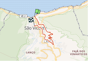
Tocht Stappen van 6,6 km beschikbaar op Madeira, Onbekend, São Vicente. Deze tocht wordt voorgesteld door Bart2015.
Beschrijving
Petite rando au départ de Sao Vicente pour monter à la chapelle Ste Fatima qui domine la petite ville. Elle longe en partie un petit levada avant de rejoindre la chapelle.
Bonne rando ...
Plaatsbepaling
Land:
Portugal
Regio :
Madeira
Departement/Provincie :
Onbekend
Gemeente :
São Vicente
Locatie:
Unknown
Vertrek:(Dec)
Vertrek:(UTM)
308244 ; 3631954 (28S) N.
Opmerkingen
Wandeltochten in de omgeving
![Tocht Stappen São Vicente - Levada da Faja do Rodrigues (Rother n°32) - Photo](https://media.geolcdn.com/t/375/260/a0ac5d9f-37de-4e30-ac38-6a9e8eb4ce99.jpg&format=jpg&maxdim=2)
![Stappen Stappen](https://static1.geolcdn.com/sitytour/trail-icons/101.png)
Levada da Faja do Rodrigues (Rother n°32)
Stappen
Medium
São Vicente,
Madeira,
Onbekend,
Portugal
![](/images/other/stat-length.png)
9,1 km | 26 km-effort
2h 52min
![](https://static1.geolcdn.com/siteimages/upload/files/16400158638029165_repeat_loop_refresh_sync_direction_icon.png)
Ja
![Tocht Te voet Seixal - Caminho dos Pessegueiros - Photo](https://media.geolcdn.com/t/375/260/db3e98f8-7ea7-41b7-b359-5ab0ad41297d.jpeg&format=jpg&maxdim=2)
![Te voet Te voet](https://static1.geolcdn.com/sitytour/trail-icons/100.png)
Caminho dos Pessegueiros
Te voet
Medium
Seixal,
Madeira,
Onbekend,
Portugal
![](/images/other/stat-length.png)
7,6 km | 23 km-effort
5h 14min
![](https://static1.geolcdn.com/siteimages/upload/files/16400158638029165_repeat_loop_refresh_sync_direction_icon.png)
Neen
![Tocht Te voet Calheta - Vereda do Lombo Barbinhas - Photo](https://media.geolcdn.com/t/375/260/db3e98f8-7ea7-41b7-b359-5ab0ad41297d.jpeg&format=jpg&maxdim=2)
![Te voet Te voet](https://static1.geolcdn.com/sitytour/trail-icons/100.png)
Vereda do Lombo Barbinhas
Te voet
Gemakkelijk
Calheta,
Madeira,
Onbekend,
Portugal
![](/images/other/stat-length.png)
4 km | 6 km-effort
1h 21min
![](https://static1.geolcdn.com/siteimages/upload/files/16400158638029165_repeat_loop_refresh_sync_direction_icon.png)
Neen
![Tocht Te voet Seixal - Levada Fajã do Rodrigues - Photo](https://media.geolcdn.com/t/375/260/ext.jpg?maxdim=2&url=https%3A%2F%2Fstatic1.geolcdn.com%2Fsiteimages%2Fupload%2Ffiles%2F1545311037marcheuse_200dpi.jpg)
![Te voet Te voet](https://static1.geolcdn.com/sitytour/trail-icons/100.png)
Levada Fajã do Rodrigues
Te voet
Gemakkelijk
Seixal,
Madeira,
Onbekend,
Portugal
![](/images/other/stat-length.png)
3,8 km | 10,9 km-effort
2h 29min
![](https://static1.geolcdn.com/siteimages/upload/files/16400158638029165_repeat_loop_refresh_sync_direction_icon.png)
Neen
![Tocht Trail São Vicente - jour 1 test - Photo](https://media.geolcdn.com/t/375/260/ext.jpg?maxdim=2&url=https%3A%2F%2Fstatic1.geolcdn.com%2Fsiteimages%2Fupload%2Ffiles%2F1524743154running.jpg)
![Trail Trail](https://static1.geolcdn.com/sitytour/trail-icons/104.png)
![Tocht Stappen São Vicente - Madeira - PR16 - Levada Fajã do Rodrigues - Photo](https://media.geolcdn.com/t/375/260/ext.jpg?maxdim=2&url=https%3A%2F%2Fstatic1.geolcdn.com%2Fsiteimages%2Fupload%2Ffiles%2F1553511878bg_sport_marche.png)
![Stappen Stappen](https://static1.geolcdn.com/sitytour/trail-icons/101.png)
Madeira - PR16 - Levada Fajã do Rodrigues
Stappen
Medium
São Vicente,
Madeira,
Onbekend,
Portugal
![](/images/other/stat-length.png)
3,8 km | 11,1 km-effort
2h 32min
![](https://static1.geolcdn.com/siteimages/upload/files/16400158638029165_repeat_loop_refresh_sync_direction_icon.png)
Neen