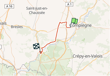
Tocht Auto Jonquières - creil plateau  - Photo
 Christophe 60
Christophe 60

Gebruiker

© OpenStreetMap contributors
Lengte
Lengte
48 km
Max. hoogte
Max. hoogte
115 m
Positief hoogteverschil
391 m
Km-Effort
Km-Effort  
53 km
Min. hoogte
Min. hoogte
24 m
Negatief hoogteverschil
396 m
Boucle
Boucle
Neen
Datum van aanmaak :
2022-03-28 01:49:45.233
Laatste wijziging :
2022-03-28 03:59:57.082

(0 Bericht)

Auto
Auto
2h09
Moeilijkheid : Heel gemakkelijk

Scan deze QR-code om de tocht te openen in de SityTrail-applicatie

Gratisgps-wandelapplicatie

Logo SityTrail SityTrail

IGN / Geografische instituten

SityTrail uit de App Store downloaden SityTrail uit Google Play downloaden

Logo SityTrail SityTrail World

De wereld gaat voor u open

SityTrail uit de App Store downloaden SityTrail uit Google Play downloaden SityTrail op Huawei AppGallery downloaden

Over ons

Tocht Auto van 48 km beschikbaar op Hauts-de-France, Oise, Jonquières. Deze tocht wordt voorgesteld door Christophe 60.

Hoogteprofiel

Plaatsbepaling

Land:
France
Regio :
Hauts-de-France
Departement/Provincie :
Oise
Gemeente :
Jonquières
Locatie:
Unknown
Vertrek:(UTM)
480812 ; 5472264 (31U) N.

Wandeltochten in de omgeving

Tocht Stappen Jaux - JAUX, Oise - Photo
Stappen
jeannine grandjean

Stappen

Medium
Jaux, Hauts-de-France, Oise, France
6,4 km | 7,7 km-effort
1h 45min
Ja
Tocht Mountainbike Lacroix-Saint-Ouen - Au bois de Marie Louise Nord - Lacroix Saint Ouen - Photo
Mountainbike
tracegps

Mountainbike

Medium
Lacroix-Saint-Ouen, Hauts-de-France, Oise, France
26 km | 30 km-effort
2h 0min
Ja
Tocht Mountainbike Armancourt - Hervé - Photo
Mountainbike
Herve Hermant

Mountainbike

Moeilijk
Armancourt, Hauts-de-France, Oise, France
31 km | 37 km-effort
2h 2min
Ja
Tocht Stappen Compiègne - Compiegne - Photo
Stappen
PatRando

Stappen

Heel gemakkelijk
Compiègne, Hauts-de-France, Oise, France
5,5 km | 6 km-effort
1h 19min
Ja
Tocht Hybride fiets Armancourt - Hermant - Photo
Hybride fiets
Herve Hermant

Hybride fiets

Gemakkelijk
Armancourt, Hauts-de-France, Oise, France
13 km | 15,5 km-effort
56min
Ja
Tocht Andere activiteiten Le Fayel - le fayel mars 2014 - Photo
Andere activiteiten
pepite473360

Andere activiteiten

Medium
Le Fayel, Hauts-de-France, Oise, France
46 km | 54 km-effort
1h 58min
Ja
Tocht Motor Le Fayel - le fayel 31 mars 2013 - Photo
Motor
pepite473360

Motor

Moeilijk
Le Fayel, Hauts-de-France, Oise, France
80 km | 97 km-effort
4h 16min
Neen
Tocht sport Le Meux - Le peux - Photo
sport
pascha

sport

Heel gemakkelijk
Le Meux, Hauts-de-France, Oise, France
11,8 km | 14,9 km-effort
Onbekend
Ja
Tocht sport Jaux - 015 - JAUX - pl des Fêtes - Photo
sport
Roland Degroise

sport

Heel gemakkelijk
Jaux, Hauts-de-France, Oise, France
11,5 km | 14,9 km-effort
Onbekend
Ja


Sluiten
Mijn abonnementen