![](/images/other/stat-length.png)
![Tocht Stappen Herbeumont - RSIH - Herbeumont - Les Fourches - Photo](https://media.geolcdn.com/t/1900/400/b7fa5229-f9d0-49b5-9815-e2ec2bd24782.jpg&format=pjpeg&maxdim=2)
RSIH - Herbeumont - Les Fourches
rsih
Gebruiker
![Lengte](/images/other/stat-length.png)
Lengte
3,8 km
![Max. hoogte](https://static1.geolcdn.com/siteimages/upload/files/1508320355ic_sort_altitude_max_24dp.png)
Max. hoogte
409 m
![Positief hoogteverschil](https://static1.geolcdn.com/siteimages/upload/files/1508320355ic_sort_den_pos_24dp.png)
Positief hoogteverschil
100 m
![Km-Effort](/images/other/stat-length.png)
Km-Effort
5,2 km
![Min. hoogte](https://static1.geolcdn.com/siteimages/upload/files/1508320355ic_sort_altitude_min_24dp.png)
Min. hoogte
307 m
![Negatief hoogteverschil](https://static1.geolcdn.com/siteimages/upload/files/1508320355ic_sort_den_neg_24dp.png)
Negatief hoogteverschil
100 m
![Boucle](https://static1.geolcdn.com/siteimages/upload/files/16400158638029165_repeat_loop_refresh_sync_direction_icon.png)
Boucle
Ja
Datum van aanmaak :
2022-03-25 14:01:47.464
Laatste wijziging :
2022-07-13 10:58:16.099
![Stappen](https://static1.geolcdn.com/sitytour/trail-icons/101.png)
1h10
Moeilijkheid : Gemakkelijk
![Scan deze QR-code om de tocht te openen in de SityTrail-applicatie](https://capi.geolives.com/qq0zvz2zws4bq2lad0pu/sitytour/trails/3180063/qr.png?size=200)
Gratisgps-wandelapplicatie
Over ons
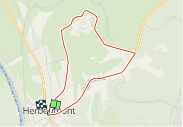
Tocht Stappen van 3,8 km beschikbaar op Wallonië, Luxemburg, Herbeumont. Deze tocht wordt voorgesteld door rsih.
Beschrijving
Balade villageoise qui passe par l'ancien centre de vacances et vous fait découvrir un magnifique point de vue sur Herbeumont et son château.
///
Dorpswandeling door het oude vakantiecentrum met een prachtig uitzicht over Herbeumont en het kasteel.
Plaatsbepaling
Land:
Belgium
Regio :
Wallonië
Departement/Provincie :
Luxemburg
Gemeente :
Herbeumont
Locatie:
Unknown
Vertrek:(Dec)
Vertrek:(UTM)
661090 ; 5516679 (31U) N.
Opmerkingen
Wandeltochten in de omgeving
![Tocht Andere activiteiten Bertrix - BX08 - Photo](https://media.geolcdn.com/t/375/260/ext.jpg?maxdim=2&url=https%3A%2F%2Fstatic1.geolcdn.com%2Fsiteimages%2Fupload%2Ffiles%2F1545311037marcheuse_200dpi.jpg)
![Andere activiteiten Andere activiteiten](https://static1.geolcdn.com/sitytour/trail-icons/900.png)
BX08
Andere activiteiten
Heel gemakkelijk
(9)
Bertrix,
Wallonië,
Luxemburg,
Belgium
![](/images/other/stat-length.png)
7,3 km | 10 km-effort
2h 30min
![](https://static1.geolcdn.com/siteimages/upload/files/16400158638029165_repeat_loop_refresh_sync_direction_icon.png)
Ja
![Stappen Stappen](https://static1.geolcdn.com/sitytour/trail-icons/101.png)
RB-Lu-23_Herbeumont_via-racc-1-et-var
Stappen
Zeer moeilijk
(4)
Herbeumont,
Wallonië,
Luxemburg,
Belgium
![](/images/other/stat-length.png)
18,6 km | 25 km-effort
5h 44min
![](https://static1.geolcdn.com/siteimages/upload/files/16400158638029165_repeat_loop_refresh_sync_direction_icon.png)
Ja
![Stappen Stappen](https://static1.geolcdn.com/sitytour/trail-icons/101.png)
RB-Lu-23_Herbeumont
Stappen
Moeilijk
(2)
Herbeumont,
Wallonië,
Luxemburg,
Belgium
![](/images/other/stat-length.png)
26 km | 35 km-effort
7h 26min
![](https://static1.geolcdn.com/siteimages/upload/files/16400158638029165_repeat_loop_refresh_sync_direction_icon.png)
Ja
![Stappen Stappen](https://static1.geolcdn.com/sitytour/trail-icons/101.png)
Marche Adeps 10 km
Stappen
Moeilijk
(6)
Herbeumont,
Wallonië,
Luxemburg,
Belgium
![](/images/other/stat-length.png)
9,1 km | 12,6 km-effort
2h 51min
![](https://static1.geolcdn.com/siteimages/upload/files/16400158638029165_repeat_loop_refresh_sync_direction_icon.png)
Ja
![Tocht Stappen Florenville - rando les epioux 15/09/2020 - Photo](https://media.geolcdn.com/t/375/260/f418135f-9d94-414f-b063-7d7f558c9ced.jpg&format=jpg&maxdim=2)
![Stappen Stappen](https://static1.geolcdn.com/sitytour/trail-icons/101.png)
rando les epioux 15/09/2020
Stappen
Heel gemakkelijk
(1)
Florenville,
Wallonië,
Luxemburg,
Belgium
![](/images/other/stat-length.png)
18,1 km | 23 km-effort
4h 7min
![](https://static1.geolcdn.com/siteimages/upload/files/16400158638029165_repeat_loop_refresh_sync_direction_icon.png)
Ja
![Tocht Stappen Florenville - 14km St Cécile vers Herbeumont - Photo](https://media.geolcdn.com/t/375/260/ext.jpg?maxdim=2&url=https%3A%2F%2Fservices.sitytrail.com%2FGeolivesWS%2FDownloadMedia.ashx%3FTrailID%3D1023598%26Media%3Dfix__20180817123348.jpg)
![Stappen Stappen](https://static1.geolcdn.com/sitytour/trail-icons/101.png)
14km St Cécile vers Herbeumont
Stappen
Medium
(1)
Florenville,
Wallonië,
Luxemburg,
Belgium
![](/images/other/stat-length.png)
14 km | 18,1 km-effort
2h 56min
![](https://static1.geolcdn.com/siteimages/upload/files/16400158638029165_repeat_loop_refresh_sync_direction_icon.png)
Ja
![Tocht Stappen Herbeumont - RSIH - Herbeumont - Les Épioux - Photo](https://media.geolcdn.com/t/375/260/ca0e741e-0f45-4c3d-9414-5f2e5834b9ce.jpg&format=jpg&maxdim=2)
![Stappen Stappen](https://static1.geolcdn.com/sitytour/trail-icons/101.png)
RSIH - Herbeumont - Les Épioux
Stappen
Moeilijk
(1)
Herbeumont,
Wallonië,
Luxemburg,
Belgium
![](/images/other/stat-length.png)
14,8 km | 19,2 km-effort
4h 21min
![](https://static1.geolcdn.com/siteimages/upload/files/16400158638029165_repeat_loop_refresh_sync_direction_icon.png)
Ja
![Tocht Stappen Herbeumont - Les Burzais - départ du gite Le bout des bois - Photo](https://media.geolcdn.com/t/375/260/ext.jpg?maxdim=2&url=https%3A%2F%2Fservices.sitytrail.com%2FGeolivesWS%2FDownloadMedia.ashx%3FTrailID%3D419104%26Media%3Dfix__20140609121902.jpg)
![Stappen Stappen](https://static1.geolcdn.com/sitytour/trail-icons/101.png)
Les Burzais - départ du gite Le bout des bois
Stappen
Medium
(3)
Herbeumont,
Wallonië,
Luxemburg,
Belgium
![](/images/other/stat-length.png)
4,2 km | 5,9 km-effort
1h 30min
![](https://static1.geolcdn.com/siteimages/upload/files/16400158638029165_repeat_loop_refresh_sync_direction_icon.png)
Ja
![Tocht Lopen Herbeumont - herbeumont libaipire - Photo](https://media.geolcdn.com/t/375/260/ext.jpg?maxdim=2&url=https%3A%2F%2Fservices.sitytrail.com%2FGeolivesWS%2FDownloadMedia.ashx%3FTrailID%3D356345%26Media%3Dfix__20141022103733.jpg)
![Lopen Lopen](https://static1.geolcdn.com/sitytour/trail-icons/103.png)
herbeumont libaipire
Lopen
Medium
(1)
Herbeumont,
Wallonië,
Luxemburg,
Belgium
![](/images/other/stat-length.png)
15,5 km | 22 km-effort
1h 46min
![](https://static1.geolcdn.com/siteimages/upload/files/16400158638029165_repeat_loop_refresh_sync_direction_icon.png)
Neen