![](/images/other/stat-length.png)
![Tocht Stappen Duranus - La cime de Roccassièra - Duranus - Photo](https://media.geolcdn.com/t/1900/400/ext.pjpeg?maxdim=2&url=https%3A%2F%2Fservices.sitytrail.com%2FGeolivesWS%2FDownloadMedia.ashx%3FTrailID%3D317948%26Media%3D17384_6.jpg)
La cime de Roccassièra - Duranus
tracegps
Gebruiker
![Lengte](/images/other/stat-length.png)
![Max. hoogte](https://static1.geolcdn.com/siteimages/upload/files/1508320355ic_sort_altitude_max_24dp.png)
![Positief hoogteverschil](https://static1.geolcdn.com/siteimages/upload/files/1508320355ic_sort_den_pos_24dp.png)
![Km-Effort](/images/other/stat-length.png)
![Min. hoogte](https://static1.geolcdn.com/siteimages/upload/files/1508320355ic_sort_altitude_min_24dp.png)
![Negatief hoogteverschil](https://static1.geolcdn.com/siteimages/upload/files/1508320355ic_sort_den_neg_24dp.png)
![Boucle](https://static1.geolcdn.com/siteimages/upload/files/16400158638029165_repeat_loop_refresh_sync_direction_icon.png)
![Stappen](https://static1.geolcdn.com/sitytour/trail-icons/101.png)
6h30
Moeilijkheid : Moeilijk
![Scan deze QR-code om de tocht te openen in de SityTrail-applicatie](https://capi.geolives.com/qq0zvz2zws4bq2lad0pu/sitytour/trails/317948/qr.png?size=200)
Gratisgps-wandelapplicatie
Over ons
Tocht Stappen van 16,3 km beschikbaar op Provence-Alpes-Côte d'Azur, Alpes-Maritimes, Duranus. Deze tocht wordt voorgesteld door tracegps.
Beschrijving
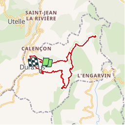
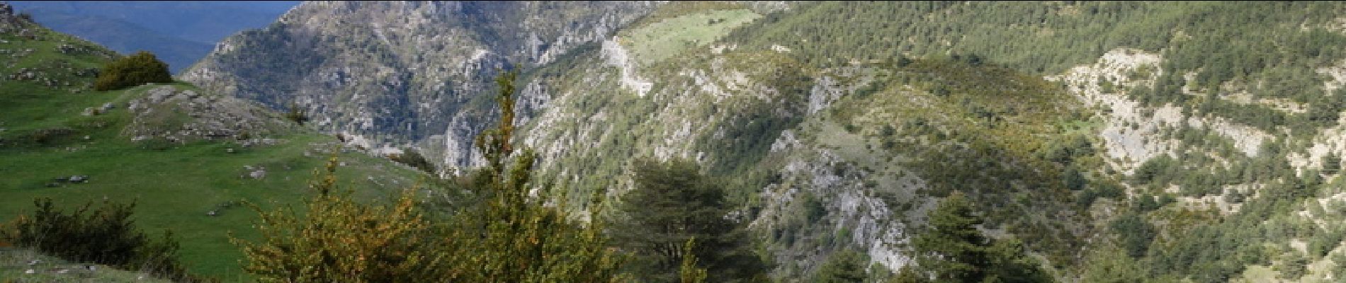
Au départ des environs de Duranus dans la vallée de la Vésubie, cette boucle propose de découvrir la cime de Roccasiera via l’ancienne mine d’arsenic de l’Eguisse, et le village ruiné de Rocca Sparviera. Attention, comme nous le constaterons au retour en étudiant la trace GPS, le point final n’est pas la cime mais une antécime, à peu près à la même altitude, quelques 200 mètres avant cette dernière.
Plaatsbepaling
Opmerkingen
Wandeltochten in de omgeving
![Tocht Stappen Utelle - Le Brec d'Utelle 1604m 19-04-22 - Photo](https://media.geolcdn.com/t/375/260/f3263017-78d2-4ab0-b769-f83aa3feee5d.jpg&format=jpg&maxdim=2)
![Stappen Stappen](https://static1.geolcdn.com/sitytour/trail-icons/101.png)
Stappen
![](/images/other/stat-length.png)
![](https://static1.geolcdn.com/siteimages/upload/files/16400158638029165_repeat_loop_refresh_sync_direction_icon.png)
![Tocht Te voet Coaraze - Rocca Sparvièra - Photo](https://media.geolcdn.com/t/375/260/b70c2ec2-277e-4b66-a927-a7ae11b9ea3a.jpeg&format=jpg&maxdim=2)
![Te voet Te voet](https://static1.geolcdn.com/sitytour/trail-icons/100.png)
Te voet
![](/images/other/stat-length.png)
![](https://static1.geolcdn.com/siteimages/upload/files/16400158638029165_repeat_loop_refresh_sync_direction_icon.png)
![Tocht Te voet Utelle - Gorges de la Vésubie - Photo](https://media.geolcdn.com/t/375/260/0a667b03-3170-487d-a7f5-45b846bd9fdf.jpeg&format=jpg&maxdim=2)
![Te voet Te voet](https://static1.geolcdn.com/sitytour/trail-icons/100.png)
Te voet
![](/images/other/stat-length.png)
![](https://static1.geolcdn.com/siteimages/upload/files/16400158638029165_repeat_loop_refresh_sync_direction_icon.png)
![Tocht Te voet Utelle - Madone d'Utelle - Photo](https://media.geolcdn.com/t/375/260/186d666d-a9cf-4d78-b5ea-394e8ee2a1a9.jpeg&format=jpg&maxdim=2)
![Te voet Te voet](https://static1.geolcdn.com/sitytour/trail-icons/100.png)
Te voet
![](/images/other/stat-length.png)
![](https://static1.geolcdn.com/siteimages/upload/files/16400158638029165_repeat_loop_refresh_sync_direction_icon.png)
![Tocht Stappen Duranus - Rocca Sparviera Rocca Siera - Photo](https://media.geolcdn.com/t/375/260/cfa7ac61-c812-43a1-a04c-577e01c4a8ee.jpg&format=jpg&maxdim=2)
![Stappen Stappen](https://static1.geolcdn.com/sitytour/trail-icons/101.png)
Stappen
![](/images/other/stat-length.png)
![](https://static1.geolcdn.com/siteimages/upload/files/16400158638029165_repeat_loop_refresh_sync_direction_icon.png)
![Tocht Stappen Coaraze - Rocca Spavierra - Photo](https://media.geolcdn.com/t/375/260/ext.jpg?maxdim=2&url=https%3A%2F%2Fstatic1.geolcdn.com%2Fsiteimages%2Fupload%2Ffiles%2F1553511878bg_sport_marche.png)
![Stappen Stappen](https://static1.geolcdn.com/sitytour/trail-icons/101.png)
Stappen
![](/images/other/stat-length.png)
![](https://static1.geolcdn.com/siteimages/upload/files/16400158638029165_repeat_loop_refresh_sync_direction_icon.png)
![Tocht Stappen Levens - Hike 2017 jour 1 - Photo](https://media.geolcdn.com/t/375/260/ext.jpg?maxdim=2&url=https%3A%2F%2Fstatic1.geolcdn.com%2Fsiteimages%2Fupload%2Ffiles%2F1553511878bg_sport_marche.png)
![Stappen Stappen](https://static1.geolcdn.com/sitytour/trail-icons/101.png)
Stappen
![](/images/other/stat-length.png)
![](https://static1.geolcdn.com/siteimages/upload/files/16400158638029165_repeat_loop_refresh_sync_direction_icon.png)
![Tocht Stappen Utelle - Cros d Utelle chapelle St Antoine - Photo](https://media.geolcdn.com/t/375/260/ccd5b578-c9f1-437b-9e91-d8a2d45b6420.jpg&format=jpg&maxdim=2)
![Stappen Stappen](https://static1.geolcdn.com/sitytour/trail-icons/101.png)
Stappen
![](/images/other/stat-length.png)
![](https://static1.geolcdn.com/siteimages/upload/files/16400158638029165_repeat_loop_refresh_sync_direction_icon.png)
![Tocht Stappen Utelle - Utelle, Brec d'Utelle - Photo](https://media.geolcdn.com/t/375/260/7d826307-5252-4f94-914a-8eefe923eff9.jpg&format=jpg&maxdim=2)
![Stappen Stappen](https://static1.geolcdn.com/sitytour/trail-icons/101.png)
Stappen
![](/images/other/stat-length.png)
![](https://static1.geolcdn.com/siteimages/upload/files/16400158638029165_repeat_loop_refresh_sync_direction_icon.png)