![](/images/other/stat-length.png)
![Tocht Stappen Saint-Senoux - La Trotinais - Saint Senoux - Photo](https://media.geolcdn.com/t/1900/400/ext.pjpeg?maxdim=2&url=https%3A%2F%2Fservices.sitytrail.com%2FGeolivesWS%2FDownloadMedia.ashx%3FTrailID%3D317849%26Media%3D17227_3.jpg)
La Trotinais - Saint Senoux
tracegps
Gebruiker
![Lengte](/images/other/stat-length.png)
![Max. hoogte](https://static1.geolcdn.com/siteimages/upload/files/1508320355ic_sort_altitude_max_24dp.png)
![Positief hoogteverschil](https://static1.geolcdn.com/siteimages/upload/files/1508320355ic_sort_den_pos_24dp.png)
![Km-Effort](/images/other/stat-length.png)
![Min. hoogte](https://static1.geolcdn.com/siteimages/upload/files/1508320355ic_sort_altitude_min_24dp.png)
![Negatief hoogteverschil](https://static1.geolcdn.com/siteimages/upload/files/1508320355ic_sort_den_neg_24dp.png)
![Boucle](https://static1.geolcdn.com/siteimages/upload/files/16400158638029165_repeat_loop_refresh_sync_direction_icon.png)
![Stappen](https://static1.geolcdn.com/sitytour/trail-icons/101.png)
3h30
Moeilijkheid : Medium
![Scan deze QR-code om de tocht te openen in de SityTrail-applicatie](https://capi.geolives.com/qq0zvz2zws4bq2lad0pu/sitytour/trails/317849/qr.png?size=200)
Gratisgps-wandelapplicatie
Over ons
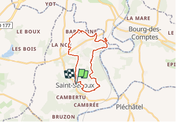
Tocht Stappen van 12,1 km beschikbaar op Bretagne, Ille-et-Vilaine, Saint-Senoux. Deze tocht wordt voorgesteld door tracegps.
Beschrijving
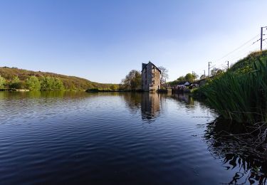
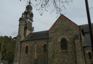
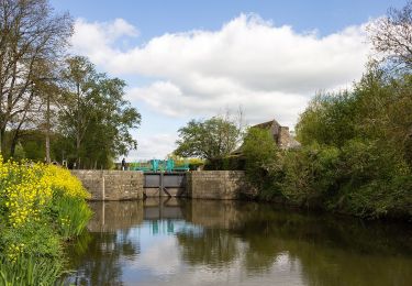
Cette randonnée, au départ de la place de l’église de Saint-Senoux, offre une belle diversité de paysages, boisements (dont une partie classée ZNIEFF, le bois de la Molière), bocage et cours d’eau, ainsi que de jolis panoramas sur les vallées du Canut et de la Vilaine (ZNIEFF: Zone Naturelle d’Intérêt Ecologique Faunistique et Floristique). Ce territoire, le bien nommé Pays des Vallons de Vilaine, propose une topographie accidentée, quasi unique dans le département, qui ravira les amateurs de randonnée. Le circuit de La Trotinais totalise en effet 320 mètres de dénivelé positif cumulé. Le bourg de Saint-Senoux et son église paroissiale Saint-Abdon (XIXème siècle) ainsi que les hameaux de La Trotinais et La Fiolais valent le coup d’œil. Retrouvez le circuit sur le site du Tourisme en haute-Bretagne Ille-et-Vilaine. ou sur le site «balades.bretagne35.com» du Comité départemental du Tourisme Haute Bretagne Ille-et-Vilaine.
Plaatsbepaling
Opmerkingen
Wandeltochten in de omgeving
![Tocht Te voet Pléchâtel - Circuit de Mainténiac - Photo](https://media.geolcdn.com/t/375/260/7fb5ae18-f1db-43e6-a6e1-b87dc82d549d.jpeg&format=jpg&maxdim=2)
![Te voet Te voet](https://static1.geolcdn.com/sitytour/trail-icons/100.png)
Te voet
![](/images/other/stat-length.png)
![](https://static1.geolcdn.com/siteimages/upload/files/16400158638029165_repeat_loop_refresh_sync_direction_icon.png)
![Tocht Te voet Pléchâtel - Circuit de la Croix des Jeunes - Photo](https://media.geolcdn.com/t/375/260/9e8b4b4f-d301-4624-a79a-f0749db2dfcc.jpeg&format=jpg&maxdim=2)
![Te voet Te voet](https://static1.geolcdn.com/sitytour/trail-icons/100.png)
Te voet
![](/images/other/stat-length.png)
![](https://static1.geolcdn.com/siteimages/upload/files/16400158638029165_repeat_loop_refresh_sync_direction_icon.png)
![Tocht Te voet Bourg-des-Comptes - Circuit des Biches - Photo](https://media.geolcdn.com/t/375/260/5a6882f1-47ea-4e81-ab0e-66797e6d831a.jpeg&format=jpg&maxdim=2)
![Te voet Te voet](https://static1.geolcdn.com/sitytour/trail-icons/100.png)
Te voet
![](/images/other/stat-length.png)
![](https://static1.geolcdn.com/siteimages/upload/files/16400158638029165_repeat_loop_refresh_sync_direction_icon.png)
![Tocht Te voet Guichen - Le moulin de la Bouëxière - Photo](https://media.geolcdn.com/t/375/260/67ed7694-dc2d-46f9-bbeb-c597511af91a.jpeg&format=jpg&maxdim=2)
![Te voet Te voet](https://static1.geolcdn.com/sitytour/trail-icons/100.png)
Te voet
![](/images/other/stat-length.png)
![](https://static1.geolcdn.com/siteimages/upload/files/16400158638029165_repeat_loop_refresh_sync_direction_icon.png)
![Tocht Te voet Guichen - La Locquenais - Photo](https://media.geolcdn.com/t/375/260/67ed7694-dc2d-46f9-bbeb-c597511af91a.jpeg&format=jpg&maxdim=2)
![Te voet Te voet](https://static1.geolcdn.com/sitytour/trail-icons/100.png)
Te voet
![](/images/other/stat-length.png)
![](https://static1.geolcdn.com/siteimages/upload/files/16400158638029165_repeat_loop_refresh_sync_direction_icon.png)
![Tocht Te voet Saint-Senoux - Circuit de la Levée - Photo](https://media.geolcdn.com/t/375/260/9e8b4b4f-d301-4624-a79a-f0749db2dfcc.jpeg&format=jpg&maxdim=2)
![Te voet Te voet](https://static1.geolcdn.com/sitytour/trail-icons/100.png)
Te voet
![](/images/other/stat-length.png)
![](https://static1.geolcdn.com/siteimages/upload/files/16400158638029165_repeat_loop_refresh_sync_direction_icon.png)
![Tocht Te voet Saint-Senoux - circuit de Cambertu - Photo](https://media.geolcdn.com/t/375/260/93b56c7a-45ee-41ec-9e8c-bf78f2aa3c2d.jpeg&format=jpg&maxdim=2)
![Te voet Te voet](https://static1.geolcdn.com/sitytour/trail-icons/100.png)
Te voet
![](/images/other/stat-length.png)
![](https://static1.geolcdn.com/siteimages/upload/files/16400158638029165_repeat_loop_refresh_sync_direction_icon.png)
![Tocht Te voet Saint-Senoux - Circuit des Pervenches - Photo](https://media.geolcdn.com/t/375/260/93b56c7a-45ee-41ec-9e8c-bf78f2aa3c2d.jpeg&format=jpg&maxdim=2)
![Te voet Te voet](https://static1.geolcdn.com/sitytour/trail-icons/100.png)
Te voet
![](/images/other/stat-length.png)
![](https://static1.geolcdn.com/siteimages/upload/files/16400158638029165_repeat_loop_refresh_sync_direction_icon.png)
![Tocht Te voet Saint-Senoux - Circuit de la Trotinais - Photo](https://media.geolcdn.com/t/375/260/467b66a9-2355-44bb-b47d-644a46c89128.jpeg&format=jpg&maxdim=2)
![Te voet Te voet](https://static1.geolcdn.com/sitytour/trail-icons/100.png)
Te voet
![](/images/other/stat-length.png)
![](https://static1.geolcdn.com/siteimages/upload/files/16400158638029165_repeat_loop_refresh_sync_direction_icon.png)