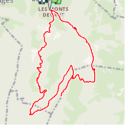
![](/images/other/stat-length.png)
![Tocht Stappen Bellecombe-en-Bauges - Crête du Mont Julioz 1498m, depuis le Mont Devant - Photo](https://media.geolcdn.com/t/1900/400/ext.pjpeg?maxdim=2&url=https%3A%2F%2Fservices.sitytrail.com%2FGeolivesWS%2FDownloadMedia.ashx%3FTrailID%3D317683%26Media%3D16978_1.jpg)
Crête du Mont Julioz 1498m, depuis le Mont Devant
tracegps
Gebruiker
![Lengte](/images/other/stat-length.png)
![Max. hoogte](https://static1.geolcdn.com/siteimages/upload/files/1508320355ic_sort_altitude_max_24dp.png)
![Positief hoogteverschil](https://static1.geolcdn.com/siteimages/upload/files/1508320355ic_sort_den_pos_24dp.png)
![Km-Effort](/images/other/stat-length.png)
![Min. hoogte](https://static1.geolcdn.com/siteimages/upload/files/1508320355ic_sort_altitude_min_24dp.png)
![Negatief hoogteverschil](https://static1.geolcdn.com/siteimages/upload/files/1508320355ic_sort_den_neg_24dp.png)
![Boucle](https://static1.geolcdn.com/siteimages/upload/files/16400158638029165_repeat_loop_refresh_sync_direction_icon.png)
![Stappen](https://static1.geolcdn.com/sitytour/trail-icons/101.png)
4h00
Moeilijkheid : Gemakkelijk
![Scan deze QR-code om de tocht te openen in de SityTrail-applicatie](https://capi.geolives.com/qq0zvz2zws4bq2lad0pu/sitytour/trails/317683/qr.png?size=200)
Gratisgps-wandelapplicatie
Over ons
Tocht Stappen van 11,5 km beschikbaar op Auvergne-Rhône-Alpes, Savoie, Bellecombe-en-Bauges. Deze tocht wordt voorgesteld door tracegps.
Beschrijving
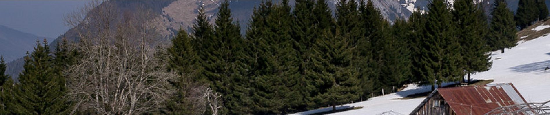
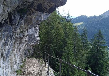
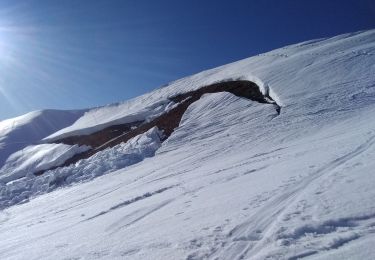
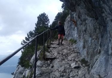
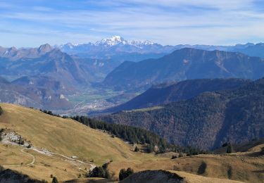
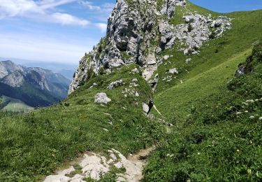
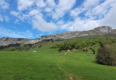
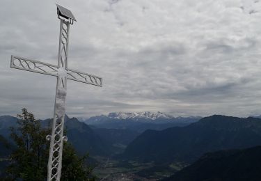
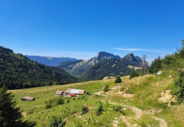
Itinéraire de montagne. Le Mont Julioz offre de beaux parcours par son arête effilée, mais aussi des randonnées moins ambitieuses à parcourir l'hiver en raquettes. En partant de Mont Devant, hameau de Bellecombe-en-Bauges, un chemin, puis une route d'alpage conduit au Reposoir pour monter au Goulet de Doucy, à travers l'alpage. Tracé dans le versant Est, un chemin atteint la crête du Mont Julioz vers 1500 mètres. De là, on peut suivre la crête en direction du sommet ou la descendre vers le Nord pour trouver la piste forestière du Bois d'Enfer, en direction du Col du Plane. Le retour emprunte le tracé de l'ancien GR96 pour éviter la route forestière et retrouver le point de départ. Description complète sur sentier-nature.com : Crête du Mont Julioz 1498 m, depuis le Mont Devant Avertissement [Pénibilité 3/3]. La randonnée en montagne l'hiver, à pieds, en raquettes, à ski est une activité dangereuse qui nécessite une grande autonomie et l'acceptation d'un degré de risque adapté aux capacités de chacun. Prendre connaissance du terrain, des conditions météorologiques et des risques d'avalanches est nécessaire avant de partir. Pour votre sécurité, nous vous invitons à respecter les règles suivantes : être bien chaussé et bien équipé, ne pas s'engager par mauvais temps, ne pas s'écarter de l'itinéraire ni des sentiers. Cet itinéraire ce déroule tout ou partie dans la Parc Naturel Régional du Massif des Bauges qui a pour mission d'étudier et de gérer ce territoire afin que les diverses activités qui s'y exercent (élevage, exploitation forestière, randonnée, etc.) soient compatibles avec la préservation de la faune, de la flore et du paysage. Participez à la protection de cet espace en respectant la réglementation.
Plaatsbepaling
Opmerkingen
Wandeltochten in de omgeving
![Tocht Stappen Bellecombe-en-Bauges - Pointe de Banc Plat en boucle - Photo](https://media.geolcdn.com/t/375/260/80b75f38-16b0-40b8-9a99-ebc551fd27ff.jpg&format=jpg&maxdim=2)
![Stappen Stappen](https://static1.geolcdn.com/sitytour/trail-icons/101.png)
Stappen
![](/images/other/stat-length.png)
![](https://static1.geolcdn.com/siteimages/upload/files/16400158638029165_repeat_loop_refresh_sync_direction_icon.png)
![Tocht Ski randonnée Bellecombe-en-Bauges - la dent des portes et sous le Trelod - Photo](https://media.geolcdn.com/t/375/260/5df2df97-f7db-4fea-9d78-8be71e3fb466.jpg&format=jpg&maxdim=2)
![Ski randonnée Ski randonnée](https://static1.geolcdn.com/sitytour/trail-icons/503.png)
Ski randonnée
![](/images/other/stat-length.png)
![](https://static1.geolcdn.com/siteimages/upload/files/16400158638029165_repeat_loop_refresh_sync_direction_icon.png)
![Tocht Stappen Bellecombe-en-Bauges - Banc plat boucle - Photo](https://media.geolcdn.com/t/375/260/a2db89fd-d92b-448f-a4ef-41a90ffed31c.jpg&format=jpg&maxdim=2)
![Stappen Stappen](https://static1.geolcdn.com/sitytour/trail-icons/101.png)
Stappen
![](/images/other/stat-length.png)
![](https://static1.geolcdn.com/siteimages/upload/files/16400158638029165_repeat_loop_refresh_sync_direction_icon.png)
![Tocht Stappen Doucy-en-Bauges - 2015-09-11 Marche Mont Trelod - Photo](https://media.geolcdn.com/t/375/260/ext.jpg?maxdim=2&url=https%3A%2F%2Fstatic1.geolcdn.com%2Fsiteimages%2Fupload%2Ffiles%2F1553511878bg_sport_marche.png)
![Stappen Stappen](https://static1.geolcdn.com/sitytour/trail-icons/101.png)
Stappen
![](/images/other/stat-length.png)
![](https://static1.geolcdn.com/siteimages/upload/files/16400158638029165_repeat_loop_refresh_sync_direction_icon.png)
![Tocht Stappen Bellecombe-en-Bauges - BAUGES: BANC PLAT via REPOSOIR - BORNETTE - REFUGE COMBE - Photo](https://media.geolcdn.com/t/375/260/e352fcdc-17f0-46fd-b7a7-5ac4f4bb5365.jpg&format=jpg&maxdim=2)
![Stappen Stappen](https://static1.geolcdn.com/sitytour/trail-icons/101.png)
Stappen
![](/images/other/stat-length.png)
![](https://static1.geolcdn.com/siteimages/upload/files/16400158638029165_repeat_loop_refresh_sync_direction_icon.png)
![Tocht Stappen Bellecombe-en-Bauges - Dent des portes e Mont Trelod - Photo](https://media.geolcdn.com/t/375/260/b0c4b228-1140-4be2-bd7d-dd2d9637b851.jpg&format=jpg&maxdim=2)
![Stappen Stappen](https://static1.geolcdn.com/sitytour/trail-icons/101.png)
Stappen
![](/images/other/stat-length.png)
![](https://static1.geolcdn.com/siteimages/upload/files/16400158638029165_repeat_loop_refresh_sync_direction_icon.png)
![Tocht Stappen Doucy-en-Bauges - 250524 Le Trelod et la Dents des Portes - Photo](https://media.geolcdn.com/t/375/260/4afdb455-3922-47f1-8f79-e9d92dd0333d.jpg&format=jpg&maxdim=2)
![Stappen Stappen](https://static1.geolcdn.com/sitytour/trail-icons/101.png)
Stappen
![](/images/other/stat-length.png)
![](https://static1.geolcdn.com/siteimages/upload/files/16400158638029165_repeat_loop_refresh_sync_direction_icon.png)
![Tocht Stappen Bellecombe-en-Bauges - La croix du Roy - Photo](https://media.geolcdn.com/t/375/260/f0613759-db59-4826-869f-3a31d0a833ec.jpg&format=jpg&maxdim=2)
![Stappen Stappen](https://static1.geolcdn.com/sitytour/trail-icons/101.png)
Stappen
![](/images/other/stat-length.png)
![](https://static1.geolcdn.com/siteimages/upload/files/16400158638029165_repeat_loop_refresh_sync_direction_icon.png)
![Tocht Stappen Bellecombe-en-Bauges - Tour de BancPlat, Dent des portes en partant du petit reposoir - Photo](https://media.geolcdn.com/t/375/260/81d53e38-45e7-40ed-845e-f728822d5f43.jpg&format=jpg&maxdim=2)
![Stappen Stappen](https://static1.geolcdn.com/sitytour/trail-icons/101.png)
Stappen
![](/images/other/stat-length.png)
![](https://static1.geolcdn.com/siteimages/upload/files/16400158638029165_repeat_loop_refresh_sync_direction_icon.png)