![](/images/other/stat-length.png)
![Tocht Mountainbike Ostabat-Asme - Le Sentier des Contrebandiers en VTT - De Ostabat à St Jean Pied de Port - Photo](https://media.geolcdn.com/t/1900/400/ext.pjpeg?maxdim=2&url=https%3A%2F%2Fservices.sitytrail.com%2FGeolivesWS%2FDownloadMedia.ashx%3FTrailID%3D317574%26Media%3D16833_3.jpg)
Le Sentier des Contrebandiers en VTT - De Ostabat à St Jean Pied de Port
tracegps
Gebruiker
![Lengte](/images/other/stat-length.png)
![Max. hoogte](https://static1.geolcdn.com/siteimages/upload/files/1508320355ic_sort_altitude_max_24dp.png)
![Positief hoogteverschil](https://static1.geolcdn.com/siteimages/upload/files/1508320355ic_sort_den_pos_24dp.png)
![Km-Effort](/images/other/stat-length.png)
![Min. hoogte](https://static1.geolcdn.com/siteimages/upload/files/1508320355ic_sort_altitude_min_24dp.png)
![Negatief hoogteverschil](https://static1.geolcdn.com/siteimages/upload/files/1508320355ic_sort_den_neg_24dp.png)
![Boucle](https://static1.geolcdn.com/siteimages/upload/files/16400158638029165_repeat_loop_refresh_sync_direction_icon.png)
![Mountainbike](https://static1.geolcdn.com/sitytour/trail-icons/202.png)
3h00
Moeilijkheid : Moeilijk
![Scan deze QR-code om de tocht te openen in de SityTrail-applicatie](https://capi.geolives.com/qq0zvz2zws4bq2lad0pu/sitytour/trails/317574/qr.png?size=200)
Gratisgps-wandelapplicatie
Over ons
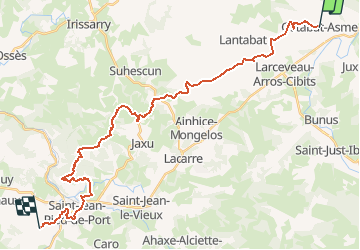
Tocht Mountainbike van 32 km beschikbaar op Nieuw-Aquitanië, Pyrénées-Atlantiques, Ostabat-Asme. Deze tocht wordt voorgesteld door tracegps.
Beschrijving
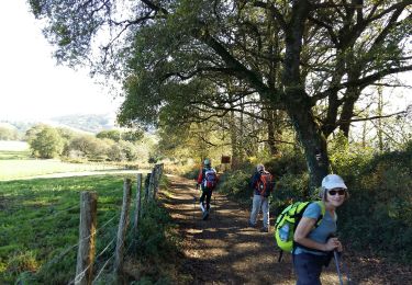
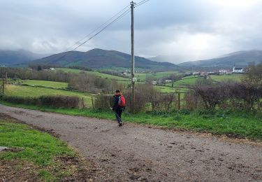
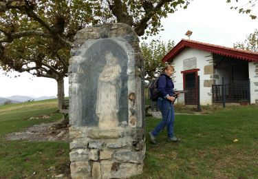
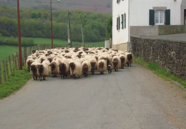
La pénibilité pour rejoindre les crêtes se fait oublier par une suite très panoramique sur les montagnes du Pays basque .Les beaux points de vues ne manquent pas et les palombières que l’on rencontre témoignent d’une activité automnale encore très présente. Avant de rejoindre Lasse, il faut se balader dans les ruelles de St Jean pied de Port qui à elles seules donnent un attrait supplémentaire à la journée. Plus de détail sur le Sentier des Contrebandiers en VTT .
Plaatsbepaling
Opmerkingen
Wandeltochten in de omgeving
![Tocht Stappen Arhansus - Balade autour d'Arhansus - Photo](https://media.geolcdn.com/t/375/260/ext.jpg?maxdim=2&url=https%3A%2F%2Fservices.sitytrail.com%2FGeolivesWS%2FDownloadMedia.ashx%3FTrailID%3D111306%26Media%3D6955_1.jpg)
![Stappen Stappen](https://static1.geolcdn.com/sitytour/trail-icons/101.png)
Stappen
![](/images/other/stat-length.png)
![](https://static1.geolcdn.com/siteimages/upload/files/16400158638029165_repeat_loop_refresh_sync_direction_icon.png)
![Tocht Stappen Uhart-Mixe - UHART MIXE journée présidents et animateurs](https://media.geolcdn.com/t/375/260/2708b30b-c90c-4afe-a2c3-fc4432d8dcc2.jpg&format=jpg&maxdim=2)
![Stappen Stappen](https://static1.geolcdn.com/sitytour/trail-icons/101.png)
Stappen
![](/images/other/stat-length.png)
![](https://static1.geolcdn.com/siteimages/upload/files/16400158638029165_repeat_loop_refresh_sync_direction_icon.png)
![Tocht Stappen Ostabat-Asme - OSTABAT-ASME St Nicolas-Soyarze-Fntaine de la vierge G3](https://media.geolcdn.com/t/375/260/3d549841-31ce-4f5c-a0c8-5f78c7f7af4e.jpg&format=jpg&maxdim=2)
![Stappen Stappen](https://static1.geolcdn.com/sitytour/trail-icons/101.png)
Stappen
![](/images/other/stat-length.png)
![](https://static1.geolcdn.com/siteimages/upload/files/16400158638029165_repeat_loop_refresh_sync_direction_icon.png)
![Tocht Stappen Uhart-Mixe - UHART-MIXE journée Presidents / animateurs](https://media.geolcdn.com/t/375/260/177f0667-f458-47f3-85ca-ac4813df1948.jpg&format=jpg&maxdim=2)
![Stappen Stappen](https://static1.geolcdn.com/sitytour/trail-icons/101.png)
Stappen
![](/images/other/stat-length.png)
![](https://static1.geolcdn.com/siteimages/upload/files/16400158638029165_repeat_loop_refresh_sync_direction_icon.png)
![Tocht Stappen Uhart-Mixe - UHART MIXE reco Circuit Urbeltz journee](https://media.geolcdn.com/t/375/260/45c7355a-71af-4b7d-aa45-c050d457011b.jpg&format=jpg&maxdim=2)
![Stappen Stappen](https://static1.geolcdn.com/sitytour/trail-icons/101.png)
Stappen
![](/images/other/stat-length.png)
![](https://static1.geolcdn.com/siteimages/upload/files/16400158638029165_repeat_loop_refresh_sync_direction_icon.png)
![Tocht Stappen Ostabat-Asme - G3 Ostabat 2023 - Photo](https://media.geolcdn.com/t/375/260/755261ed-3819-48f8-8d80-85c5c292cf75.jpg&format=jpg&maxdim=2)
![Stappen Stappen](https://static1.geolcdn.com/sitytour/trail-icons/101.png)
Stappen
![](/images/other/stat-length.png)
![](https://static1.geolcdn.com/siteimages/upload/files/16400158638029165_repeat_loop_refresh_sync_direction_icon.png)
![Tocht Stappen Ostabat-Asme - OSTABAT G3 Chapelles St Nicolas et Soyarze reco](https://media.geolcdn.com/t/375/260/40cc9732-ad92-4c39-b129-bbdc47d5625e.jpg&format=jpg&maxdim=2)
![Stappen Stappen](https://static1.geolcdn.com/sitytour/trail-icons/101.png)
Stappen
![](/images/other/stat-length.png)
![](https://static1.geolcdn.com/siteimages/upload/files/16400158638029165_repeat_loop_refresh_sync_direction_icon.png)
![Stappen Stappen](https://static1.geolcdn.com/sitytour/trail-icons/101.png)
Stappen
![](/images/other/stat-length.png)
![](https://static1.geolcdn.com/siteimages/upload/files/16400158638029165_repeat_loop_refresh_sync_direction_icon.png)
![Tocht Stappen Ostabat-Asme - Ostabat et Haranbeltz - Photo](https://media.geolcdn.com/t/375/260/ext.jpg?maxdim=2&url=https%3A%2F%2Fservices.sitytrail.com%2FGeolivesWS%2FDownloadMedia.ashx%3FTrailID%3D333764%26Media%3D20140812113525.jpg)
![Stappen Stappen](https://static1.geolcdn.com/sitytour/trail-icons/101.png)
Stappen
![](/images/other/stat-length.png)
![](https://static1.geolcdn.com/siteimages/upload/files/16400158638029165_repeat_loop_refresh_sync_direction_icon.png)