![](/images/other/stat-length.png)
![Tocht Mountainbike La Bruffière - Circuit de la Sèvre Nantaise - La Bruffière - Photo](https://media.geolcdn.com/t/1900/400/ext.pjpeg?maxdim=2&url=https%3A%2F%2Fservices.sitytrail.com%2FGeolivesWS%2FDownloadMedia.ashx%3FTrailID%3D317514%26Media%3D16753_6.jpg)
Circuit de la Sèvre Nantaise - La Bruffière
tracegps
Gebruiker
![Lengte](/images/other/stat-length.png)
Lengte
25 km
![Max. hoogte](https://static1.geolcdn.com/siteimages/upload/files/1508320355ic_sort_altitude_max_24dp.png)
Max. hoogte
97 m
![Positief hoogteverschil](https://static1.geolcdn.com/siteimages/upload/files/1508320355ic_sort_den_pos_24dp.png)
Positief hoogteverschil
287 m
![Km-Effort](/images/other/stat-length.png)
Km-Effort
29 km
![Min. hoogte](https://static1.geolcdn.com/siteimages/upload/files/1508320355ic_sort_altitude_min_24dp.png)
Min. hoogte
34 m
![Negatief hoogteverschil](https://static1.geolcdn.com/siteimages/upload/files/1508320355ic_sort_den_neg_24dp.png)
Negatief hoogteverschil
285 m
![Boucle](https://static1.geolcdn.com/siteimages/upload/files/16400158638029165_repeat_loop_refresh_sync_direction_icon.png)
Boucle
Ja
Datum van aanmaak :
2014-12-10 00:00:00.0
Laatste wijziging :
2014-12-10 00:00:00.0
![Mountainbike](https://static1.geolcdn.com/sitytour/trail-icons/202.png)
2h00
Moeilijkheid : Medium
![Scan deze QR-code om de tocht te openen in de SityTrail-applicatie](https://capi.geolives.com/qq0zvz2zws4bq2lad0pu/sitytour/trails/317514/qr.png?size=200)
Gratisgps-wandelapplicatie
Over ons
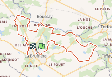
Tocht Mountainbike van 25 km beschikbaar op Pays de la Loire, Vendée, La Bruffière. Deze tocht wordt voorgesteld door tracegps.
Beschrijving
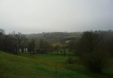
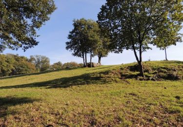
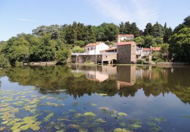
Départ du parking rue du Stade. Circuit réservé aux adeptes du VTT, celui-ci emprunte les côteaux de la Sèvre Nantaise avec en option un passage sur un ancien terrain de moto Cross au Grang Goulet. Retrouvez le circuit sur le site de la commune de La Bruffière.
Plaatsbepaling
Land:
France
Regio :
Pays de la Loire
Departement/Provincie :
Vendée
Gemeente :
La Bruffière
Locatie:
Unknown
Vertrek:(Dec)
Vertrek:(UTM)
637252 ; 5208520 (30T) N.
Opmerkingen
Wandeltochten in de omgeving
![Tocht Te voet Boussay - Les Rochers - Photo](https://media.geolcdn.com/t/375/260/ext.jpg?maxdim=2&url=https%3A%2F%2Fmedia.geolcdn.com%2Ff%2F3ecea909-2cb0-40d7-a89a-0b1bd73102e1.jpeg)
![Te voet Te voet](https://static1.geolcdn.com/sitytour/trail-icons/100.png)
Les Rochers
Te voet
Gemakkelijk
Boussay,
Pays de la Loire,
Loire-Atlantique,
France
![](/images/other/stat-length.png)
12,1 km | 13,8 km-effort
3h 7min
![](https://static1.geolcdn.com/siteimages/upload/files/16400158638029165_repeat_loop_refresh_sync_direction_icon.png)
Ja
![Tocht Stappen Cugand - Hucheloup Hu - Photo](https://media.geolcdn.com/t/375/260/ext.jpg?maxdim=2&url=https%3A%2F%2Fmedia.geolcdn.com%2Ff%2F28b218cd-cc11-4b98-988e-6a2eaaaf2ccc.jpg)
![Stappen Stappen](https://static1.geolcdn.com/sitytour/trail-icons/101.png)
![Tocht Stappen Cugand - Hucheloup - Photo](https://media.geolcdn.com/t/375/260/ext.jpg?maxdim=2&url=https%3A%2F%2Fmedia.geolcdn.com%2Ff%2F6d1dbebb-a4ed-4e46-ab55-94ff3fc1f0e2.jpg)
![Stappen Stappen](https://static1.geolcdn.com/sitytour/trail-icons/101.png)
![Tocht Stappen La Bruffière - boucle Boussay Hucheloup - Photo](https://media.geolcdn.com/t/375/260/ext.jpg?maxdim=2&url=https%3A%2F%2Fmedia.geolcdn.com%2Ff%2Fea114df9-7e90-42f6-b74a-1bf920b6e24a.jpg)
![Stappen Stappen](https://static1.geolcdn.com/sitytour/trail-icons/101.png)
boucle Boussay Hucheloup
Stappen
Medium
La Bruffière,
Pays de la Loire,
Vendée,
France
![](/images/other/stat-length.png)
17,4 km | 21 km-effort
3h 59min
![](https://static1.geolcdn.com/siteimages/upload/files/16400158638029165_repeat_loop_refresh_sync_direction_icon.png)
Ja
![Tocht Mountainbike La Bruffière - Circuit des hameaux - La Bruffière - Photo](https://media.geolcdn.com/t/375/260/ext.jpg?maxdim=2&url=https%3A%2F%2Fservices.sitytrail.com%2FGeolivesWS%2FDownloadMedia.ashx%3FTrailID%3D317513%26Media%3D16752_3.jpg)
![Mountainbike Mountainbike](https://static1.geolcdn.com/sitytour/trail-icons/202.png)
Circuit des hameaux - La Bruffière
Mountainbike
Medium
La Bruffière,
Pays de la Loire,
Vendée,
France
![](/images/other/stat-length.png)
23 km | 25 km-effort
2h 0min
![](https://static1.geolcdn.com/siteimages/upload/files/16400158638029165_repeat_loop_refresh_sync_direction_icon.png)
Ja
![Tocht Mountainbike La Bruffière - Circuit des étangs - long - La Bruffière - Photo](https://media.geolcdn.com/t/375/260/ext.jpg?maxdim=2&url=https%3A%2F%2Fservices.sitytrail.com%2FGeolivesWS%2FDownloadMedia.ashx%3FTrailID%3D317512%26Media%3D16751_3.jpg)
![Mountainbike Mountainbike](https://static1.geolcdn.com/sitytour/trail-icons/202.png)
Circuit des étangs - long - La Bruffière
Mountainbike
Medium
La Bruffière,
Pays de la Loire,
Vendée,
France
![](/images/other/stat-length.png)
22 km | 23 km-effort
1h 49min
![](https://static1.geolcdn.com/siteimages/upload/files/16400158638029165_repeat_loop_refresh_sync_direction_icon.png)
Ja
![Tocht Mountainbike La Bruffière - Circuit des étangs - court - La Bruffière - Photo](https://media.geolcdn.com/t/375/260/ext.jpg?maxdim=2&url=https%3A%2F%2Fservices.sitytrail.com%2FGeolivesWS%2FDownloadMedia.ashx%3FTrailID%3D317511%26Media%3D16750_4.jpg)
![Mountainbike Mountainbike](https://static1.geolcdn.com/sitytour/trail-icons/202.png)
Circuit des étangs - court - La Bruffière
Mountainbike
Gemakkelijk
La Bruffière,
Pays de la Loire,
Vendée,
France
![](/images/other/stat-length.png)
14,6 km | 15,8 km-effort
1h 19min
![](https://static1.geolcdn.com/siteimages/upload/files/16400158638029165_repeat_loop_refresh_sync_direction_icon.png)
Ja
![Tocht Stappen La Bruffière - Circuit des châtelaines - La Bruffière - Photo](https://media.geolcdn.com/t/375/260/ext.jpg?maxdim=2&url=https%3A%2F%2Fservices.sitytrail.com%2FGeolivesWS%2FDownloadMedia.ashx%3FTrailID%3D317510%26Media%3D16749_6.jpg)
![Stappen Stappen](https://static1.geolcdn.com/sitytour/trail-icons/101.png)
Circuit des châtelaines - La Bruffière
Stappen
Moeilijk
La Bruffière,
Pays de la Loire,
Vendée,
France
![](/images/other/stat-length.png)
15 km | 17,2 km-effort
3h 45min
![](https://static1.geolcdn.com/siteimages/upload/files/16400158638029165_repeat_loop_refresh_sync_direction_icon.png)
Ja
![Tocht Stappen La Bruffière - Circuit de l'étang Beau Soleil - La Bruffière - Photo](https://media.geolcdn.com/t/375/260/ext.jpg?maxdim=2&url=https%3A%2F%2Fservices.sitytrail.com%2FGeolivesWS%2FDownloadMedia.ashx%3FTrailID%3D317509%26Media%3D16748_6.jpg)
![Stappen Stappen](https://static1.geolcdn.com/sitytour/trail-icons/101.png)
Circuit de l'étang Beau Soleil - La Bruffière
Stappen
Medium
La Bruffière,
Pays de la Loire,
Vendée,
France
![](/images/other/stat-length.png)
10,9 km | 12,1 km-effort
2h 45min
![](https://static1.geolcdn.com/siteimages/upload/files/16400158638029165_repeat_loop_refresh_sync_direction_icon.png)
Ja