![](/images/other/stat-length.png)
![Tocht Mountainbike Saumont - Le Saumont vers Montagnac, par les Grand et Petit Auvignon - Photo](https://media.geolcdn.com/t/1900/400/ext.pjpeg?maxdim=2&url=https%3A%2F%2Fservices.sitytrail.com%2FGeolivesWS%2FDownloadMedia.ashx%3FTrailID%3D317338%26Media%3D16546_5.jpg)
Le Saumont vers Montagnac, par les Grand et Petit Auvignon
tracegps
Gebruiker
![Lengte](/images/other/stat-length.png)
![Max. hoogte](https://static1.geolcdn.com/siteimages/upload/files/1508320355ic_sort_altitude_max_24dp.png)
![Positief hoogteverschil](https://static1.geolcdn.com/siteimages/upload/files/1508320355ic_sort_den_pos_24dp.png)
![Km-Effort](/images/other/stat-length.png)
![Min. hoogte](https://static1.geolcdn.com/siteimages/upload/files/1508320355ic_sort_altitude_min_24dp.png)
![Negatief hoogteverschil](https://static1.geolcdn.com/siteimages/upload/files/1508320355ic_sort_den_neg_24dp.png)
![Boucle](https://static1.geolcdn.com/siteimages/upload/files/16400158638029165_repeat_loop_refresh_sync_direction_icon.png)
![Mountainbike](https://static1.geolcdn.com/sitytour/trail-icons/202.png)
1h49
Moeilijkheid : Medium
![Scan deze QR-code om de tocht te openen in de SityTrail-applicatie](https://capi.geolives.com/qq0zvz2zws4bq2lad0pu/sitytour/trails/317338/qr.png?size=200)
Gratisgps-wandelapplicatie
Over ons
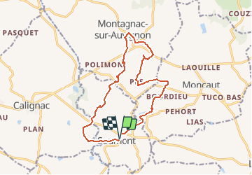
Tocht Mountainbike van 15,1 km beschikbaar op Nieuw-Aquitanië, Lot-et-Garonne, Saumont. Deze tocht wordt voorgesteld door tracegps.
Beschrijving
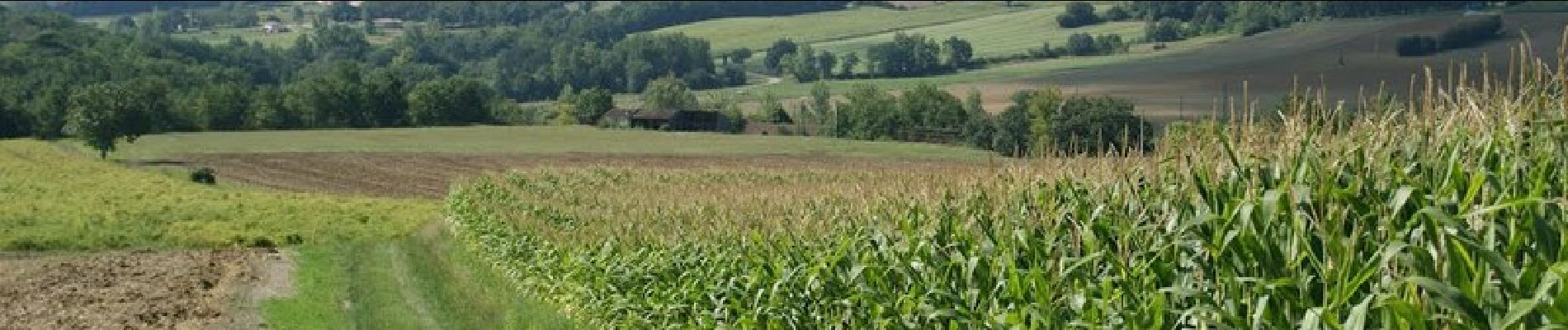
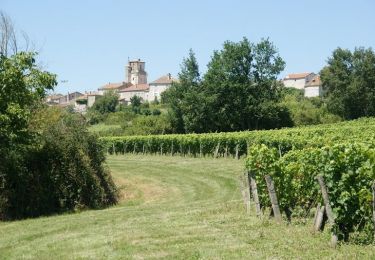
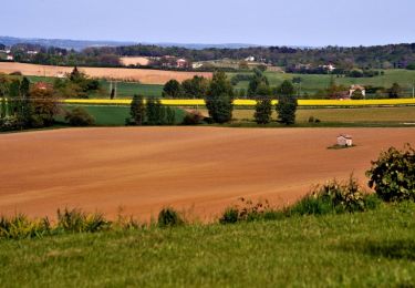
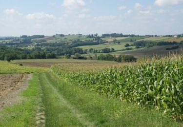
Ils sont deux, le Petit rejoint le Grand. Leurs vallées se ressemblent comme des sœurs, plaines verdoyantes avec prairies et champs de maïs, coteaux calcaires en rive droite parfois escarpés. Départ de’ la mairie de Le Saumont. Téléchargez la fiche de cette randonnée sur le site du Tourisme du Lot et Garonne.
Plaatsbepaling
Opmerkingen
Wandeltochten in de omgeving
![Tocht Stappen Nomdieu - le Nomdieu à la découverte des cadrans solaires - Photo](https://media.geolcdn.com/t/375/260/f04d7cc9-3b4c-4a60-8454-f740eac0d5c6.jpg&format=jpg&maxdim=2)
![Stappen Stappen](https://static1.geolcdn.com/sitytour/trail-icons/101.png)
Stappen
![](/images/other/stat-length.png)
![](https://static1.geolcdn.com/siteimages/upload/files/16400158638029165_repeat_loop_refresh_sync_direction_icon.png)
![Tocht Te voet Nomdieu - Le Nomdieu, vers le point de vue de l'église de Saint-Lary 8.9 km - Photo](https://media.geolcdn.com/t/375/260/5bb70d90-4b4a-43ed-83a4-640fd202f525.jpeg&format=jpg&maxdim=2)
![Te voet Te voet](https://static1.geolcdn.com/sitytour/trail-icons/100.png)
Te voet
![](/images/other/stat-length.png)
![](https://static1.geolcdn.com/siteimages/upload/files/16400158638029165_repeat_loop_refresh_sync_direction_icon.png)
![Tocht Te voet Nomdieu - Le Nomdieu, vers le point de vue de l'église de Saint-Lary variante 7.9 km - Photo](https://media.geolcdn.com/t/375/260/5bb70d90-4b4a-43ed-83a4-640fd202f525.jpeg&format=jpg&maxdim=2)
![Te voet Te voet](https://static1.geolcdn.com/sitytour/trail-icons/100.png)
Te voet
![](/images/other/stat-length.png)
![](https://static1.geolcdn.com/siteimages/upload/files/16400158638029165_repeat_loop_refresh_sync_direction_icon.png)
![Tocht Te voet Nomdieu - Le Nomdieu, vers le point de vue de l'église de Saint-Lary variante 3.7 km - Photo](https://media.geolcdn.com/t/375/260/5bb70d90-4b4a-43ed-83a4-640fd202f525.jpeg&format=jpg&maxdim=2)
![Te voet Te voet](https://static1.geolcdn.com/sitytour/trail-icons/100.png)
Te voet
![](/images/other/stat-length.png)
![](https://static1.geolcdn.com/siteimages/upload/files/16400158638029165_repeat_loop_refresh_sync_direction_icon.png)
![Tocht Te voet Nomdieu - Le Nomdieu, à la découverte des cadrans solaires 13.9 km - Photo](https://media.geolcdn.com/t/375/260/5bb70d90-4b4a-43ed-83a4-640fd202f525.jpeg&format=jpg&maxdim=2)
![Te voet Te voet](https://static1.geolcdn.com/sitytour/trail-icons/100.png)
Te voet
![](/images/other/stat-length.png)
![](https://static1.geolcdn.com/siteimages/upload/files/16400158638029165_repeat_loop_refresh_sync_direction_icon.png)
![Tocht Paard Montagnac-sur-Auvignon - Petite montagne d'Albret - Montagnac sur Auvignon - Photo](https://media.geolcdn.com/t/375/260/ext.jpg?maxdim=2&url=https%3A%2F%2Fservices.sitytrail.com%2FGeolivesWS%2FDownloadMedia.ashx%3FTrailID%3D317842%26Media%3D17216_1.jpg)
![Paard Paard](https://static1.geolcdn.com/sitytour/trail-icons/300.png)
Paard
![](/images/other/stat-length.png)
![](https://static1.geolcdn.com/siteimages/upload/files/16400158638029165_repeat_loop_refresh_sync_direction_icon.png)
![Tocht Mountainbike Montagnac-sur-Auvignon - Petite montagne d'Albret - Montagnac sur Auvignon - Photo](https://media.geolcdn.com/t/375/260/ext.jpg?maxdim=2&url=https%3A%2F%2Fservices.sitytrail.com%2FGeolivesWS%2FDownloadMedia.ashx%3FTrailID%3D317841%26Media%3D17216_5.jpg)
![Mountainbike Mountainbike](https://static1.geolcdn.com/sitytour/trail-icons/202.png)
Mountainbike
![](/images/other/stat-length.png)
![](https://static1.geolcdn.com/siteimages/upload/files/16400158638029165_repeat_loop_refresh_sync_direction_icon.png)
![Tocht Stappen Montagnac-sur-Auvignon - Petite montagne d'Albret - Montagnac sur Auvignon - Photo](https://media.geolcdn.com/t/375/260/ext.jpg?maxdim=2&url=https%3A%2F%2Fservices.sitytrail.com%2FGeolivesWS%2FDownloadMedia.ashx%3FTrailID%3D317840%26Media%3D17216_5.jpg)
![Stappen Stappen](https://static1.geolcdn.com/sitytour/trail-icons/101.png)
Stappen
![](/images/other/stat-length.png)
![](https://static1.geolcdn.com/siteimages/upload/files/16400158638029165_repeat_loop_refresh_sync_direction_icon.png)
![Tocht Stappen Saumont - Le Saumont vers Montagnac, par les Grand et Petit Auvignon - Photo](https://media.geolcdn.com/t/375/260/ext.jpg?maxdim=2&url=https%3A%2F%2Fservices.sitytrail.com%2FGeolivesWS%2FDownloadMedia.ashx%3FTrailID%3D317337%26Media%3D16546_5.jpg)
![Stappen Stappen](https://static1.geolcdn.com/sitytour/trail-icons/101.png)
Stappen
![](/images/other/stat-length.png)
![](https://static1.geolcdn.com/siteimages/upload/files/16400158638029165_repeat_loop_refresh_sync_direction_icon.png)