![](/images/other/stat-length.png)
![Tocht Mountainbike Nomdieu - Le Nomdieu vers le point de vue de l'église de St-Lary - Photo](https://media.geolcdn.com/t/1900/400/ext.pjpeg?maxdim=2&url=https%3A%2F%2Fservices.sitytrail.com%2FGeolivesWS%2FDownloadMedia.ashx%3FTrailID%3D317331%26Media%3D16537_1.jpg)
Le Nomdieu vers le point de vue de l'église de St-Lary
tracegps
Gebruiker
![Lengte](/images/other/stat-length.png)
![Max. hoogte](https://static1.geolcdn.com/siteimages/upload/files/1508320355ic_sort_altitude_max_24dp.png)
![Positief hoogteverschil](https://static1.geolcdn.com/siteimages/upload/files/1508320355ic_sort_den_pos_24dp.png)
![Km-Effort](/images/other/stat-length.png)
![Min. hoogte](https://static1.geolcdn.com/siteimages/upload/files/1508320355ic_sort_altitude_min_24dp.png)
![Negatief hoogteverschil](https://static1.geolcdn.com/siteimages/upload/files/1508320355ic_sort_den_neg_24dp.png)
![Boucle](https://static1.geolcdn.com/siteimages/upload/files/16400158638029165_repeat_loop_refresh_sync_direction_icon.png)
![Mountainbike](https://static1.geolcdn.com/sitytour/trail-icons/202.png)
1h10
Moeilijkheid : Gemakkelijk
![Scan deze QR-code om de tocht te openen in de SityTrail-applicatie](https://capi.geolives.com/qq0zvz2zws4bq2lad0pu/sitytour/trails/317331/qr.png?size=200)
Gratisgps-wandelapplicatie
Over ons
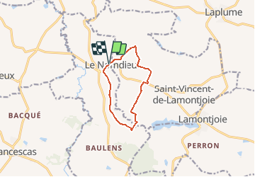
Tocht Mountainbike van 8,8 km beschikbaar op Nieuw-Aquitanië, Lot-et-Garonne, Nomdieu. Deze tocht wordt voorgesteld door tracegps.
Beschrijving
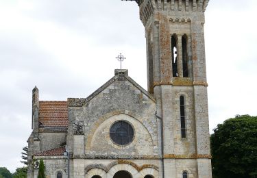
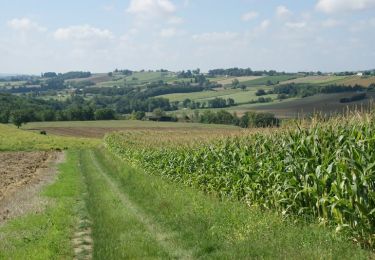
Du Nomdieu à l’église de Saint-Lary, le regard porte loin, sur les collines arrondies de l’Albret. Se profilent à l’horizon les villages perchés de Montagnac-sur-Auvignon, Moncaut, Laplume, Fieux, etc… Départ du parking en dessous de l’église Téléchargez la fiche de cette randonnée sur le site du Tourisme du Lot et Garonne.
Plaatsbepaling
Opmerkingen
Wandeltochten in de omgeving
![Tocht Te voet Saint-Vincent-de-Lamontjoie - Saint-Vincent-de-Lamontjoie, balade vers le lac de Lambronne variante 8 km - Photo](https://media.geolcdn.com/t/375/260/65291312-7a13-4e28-81f9-283781c16970.jpeg&format=jpg&maxdim=2)
![Te voet Te voet](https://static1.geolcdn.com/sitytour/trail-icons/100.png)
Te voet
![](/images/other/stat-length.png)
![](https://static1.geolcdn.com/siteimages/upload/files/16400158638029165_repeat_loop_refresh_sync_direction_icon.png)
![Tocht Te voet Lamontjoie - Lamontjoie, bastide de Gascogne 7.8 km - Photo](https://media.geolcdn.com/t/375/260/59fb9cf4-5bec-49cb-aad6-f0ed83517ecf.jpeg&format=jpg&maxdim=2)
![Te voet Te voet](https://static1.geolcdn.com/sitytour/trail-icons/100.png)
Te voet
![](/images/other/stat-length.png)
![](https://static1.geolcdn.com/siteimages/upload/files/16400158638029165_repeat_loop_refresh_sync_direction_icon.png)
![Tocht Stappen Nomdieu - le Nomdieu à la découverte des cadrans solaires - Photo](https://media.geolcdn.com/t/375/260/f04d7cc9-3b4c-4a60-8454-f740eac0d5c6.jpg&format=jpg&maxdim=2)
![Stappen Stappen](https://static1.geolcdn.com/sitytour/trail-icons/101.png)
Stappen
![](/images/other/stat-length.png)
![](https://static1.geolcdn.com/siteimages/upload/files/16400158638029165_repeat_loop_refresh_sync_direction_icon.png)
![Tocht Te voet Nomdieu - Le Nomdieu, vers le point de vue de l'église de Saint-Lary 8.9 km - Photo](https://media.geolcdn.com/t/375/260/5bb70d90-4b4a-43ed-83a4-640fd202f525.jpeg&format=jpg&maxdim=2)
![Te voet Te voet](https://static1.geolcdn.com/sitytour/trail-icons/100.png)
Te voet
![](/images/other/stat-length.png)
![](https://static1.geolcdn.com/siteimages/upload/files/16400158638029165_repeat_loop_refresh_sync_direction_icon.png)
![Tocht Te voet Nomdieu - Le Nomdieu, vers le point de vue de l'église de Saint-Lary variante 7.9 km - Photo](https://media.geolcdn.com/t/375/260/5bb70d90-4b4a-43ed-83a4-640fd202f525.jpeg&format=jpg&maxdim=2)
![Te voet Te voet](https://static1.geolcdn.com/sitytour/trail-icons/100.png)
Te voet
![](/images/other/stat-length.png)
![](https://static1.geolcdn.com/siteimages/upload/files/16400158638029165_repeat_loop_refresh_sync_direction_icon.png)
![Tocht Te voet Nomdieu - Le Nomdieu, vers le point de vue de l'église de Saint-Lary variante 3.7 km - Photo](https://media.geolcdn.com/t/375/260/5bb70d90-4b4a-43ed-83a4-640fd202f525.jpeg&format=jpg&maxdim=2)
![Te voet Te voet](https://static1.geolcdn.com/sitytour/trail-icons/100.png)
Te voet
![](/images/other/stat-length.png)
![](https://static1.geolcdn.com/siteimages/upload/files/16400158638029165_repeat_loop_refresh_sync_direction_icon.png)
![Tocht Te voet Nomdieu - Le Nomdieu, à la découverte des cadrans solaires 13.9 km - Photo](https://media.geolcdn.com/t/375/260/5bb70d90-4b4a-43ed-83a4-640fd202f525.jpeg&format=jpg&maxdim=2)
![Te voet Te voet](https://static1.geolcdn.com/sitytour/trail-icons/100.png)
Te voet
![](/images/other/stat-length.png)
![](https://static1.geolcdn.com/siteimages/upload/files/16400158638029165_repeat_loop_refresh_sync_direction_icon.png)
![Tocht Mountainbike Saumont - Le Saumont vers Montagnac, par les Grand et Petit Auvignon - Photo](https://media.geolcdn.com/t/375/260/ext.jpg?maxdim=2&url=https%3A%2F%2Fservices.sitytrail.com%2FGeolivesWS%2FDownloadMedia.ashx%3FTrailID%3D317338%26Media%3D16546_5.jpg)
![Mountainbike Mountainbike](https://static1.geolcdn.com/sitytour/trail-icons/202.png)
Mountainbike
![](/images/other/stat-length.png)
![](https://static1.geolcdn.com/siteimages/upload/files/16400158638029165_repeat_loop_refresh_sync_direction_icon.png)
![Tocht Stappen Saumont - Le Saumont vers Montagnac, par les Grand et Petit Auvignon - Photo](https://media.geolcdn.com/t/375/260/ext.jpg?maxdim=2&url=https%3A%2F%2Fservices.sitytrail.com%2FGeolivesWS%2FDownloadMedia.ashx%3FTrailID%3D317337%26Media%3D16546_5.jpg)
![Stappen Stappen](https://static1.geolcdn.com/sitytour/trail-icons/101.png)
Stappen
![](/images/other/stat-length.png)
![](https://static1.geolcdn.com/siteimages/upload/files/16400158638029165_repeat_loop_refresh_sync_direction_icon.png)