![](/images/other/stat-length.png)
![Tocht Paard Saint-Broladre - Voie Verte de la Baie du Mont-Saint-Michel - Photo](https://media.geolcdn.com/t/1900/400/ext.pjpeg?maxdim=2&url=https%3A%2F%2Fservices.sitytrail.com%2FGeolivesWS%2FDownloadMedia.ashx%3FTrailID%3D317262%26Media%3D16446_5.jpg)
Voie Verte de la Baie du Mont-Saint-Michel
tracegps
Gebruiker
![Lengte](/images/other/stat-length.png)
Lengte
14 km
![Max. hoogte](https://static1.geolcdn.com/siteimages/upload/files/1508320355ic_sort_altitude_max_24dp.png)
Max. hoogte
12 m
![Positief hoogteverschil](https://static1.geolcdn.com/siteimages/upload/files/1508320355ic_sort_den_pos_24dp.png)
Positief hoogteverschil
45 m
![Km-Effort](/images/other/stat-length.png)
Km-Effort
14,6 km
![Min. hoogte](https://static1.geolcdn.com/siteimages/upload/files/1508320355ic_sort_altitude_min_24dp.png)
Min. hoogte
4 m
![Negatief hoogteverschil](https://static1.geolcdn.com/siteimages/upload/files/1508320355ic_sort_den_neg_24dp.png)
Negatief hoogteverschil
45 m
![Boucle](https://static1.geolcdn.com/siteimages/upload/files/16400158638029165_repeat_loop_refresh_sync_direction_icon.png)
Boucle
Neen
Datum van aanmaak :
2014-12-10 00:00:00.0
Laatste wijziging :
2014-12-10 00:00:00.0
![Paard](https://static1.geolcdn.com/sitytour/trail-icons/300.png)
2h00
Moeilijkheid : Medium
![Scan deze QR-code om de tocht te openen in de SityTrail-applicatie](https://capi.geolives.com/qq0zvz2zws4bq2lad0pu/sitytour/trails/317262/qr.png?size=200)
Gratisgps-wandelapplicatie
Over ons
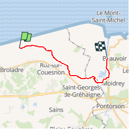
Tocht Paard van 14 km beschikbaar op Bretagne, Ille-et-Vilaine, Saint-Broladre. Deze tocht wordt voorgesteld door tracegps.
Beschrijving
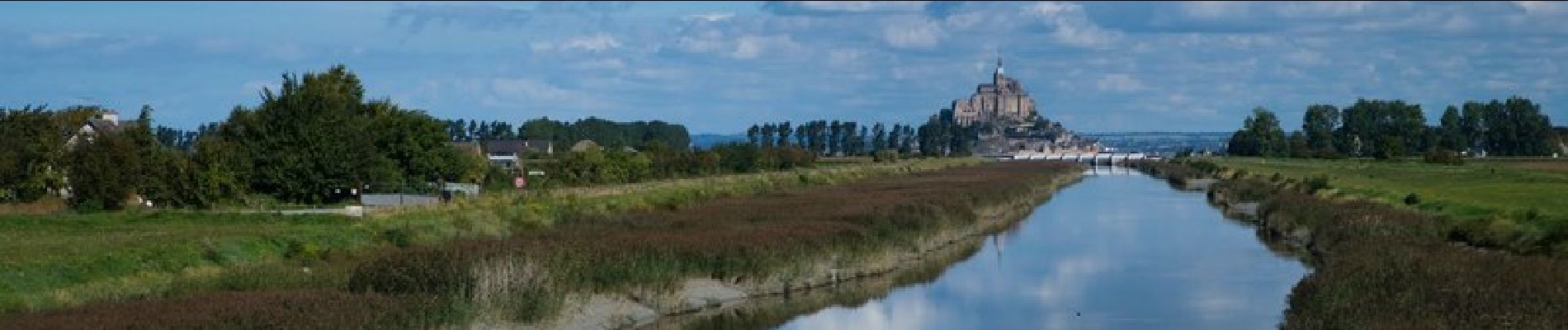
Le parcours est un peu en retrait de la mer, sur une ancienne digue, au milieu des polders. La Voie Verte serpente entre 2 rangées de peupliers et sur une bonne partie du trajet, l’on aperçoit le célèbre Mont-Saint-Michel. Allure demandée pour les cavaliers : le pas !!!
Plaatsbepaling
Land:
France
Regio :
Bretagne
Departement/Provincie :
Ille-et-Vilaine
Gemeente :
Saint-Broladre
Locatie:
Unknown
Vertrek:(Dec)
Vertrek:(UTM)
600680 ; 5384675 (30U) N.
Opmerkingen
Wandeltochten in de omgeving
![Tocht Te voet Saint-Georges-de-Gréhaigne - Circuit du Petit Bois & de la Grève - Photo](https://media.geolcdn.com/t/375/260/5902253f-7208-4ff1-b384-45fcc25c7a03.jpeg&format=jpg&maxdim=2)
![Te voet Te voet](https://static1.geolcdn.com/sitytour/trail-icons/100.png)
Circuit du Petit Bois & de la Grève
Te voet
Gemakkelijk
Saint-Georges-de-Gréhaigne,
Bretagne,
Ille-et-Vilaine,
France
![](/images/other/stat-length.png)
9,1 km | 10,4 km-effort
2h 21min
![](https://static1.geolcdn.com/siteimages/upload/files/16400158638029165_repeat_loop_refresh_sync_direction_icon.png)
Ja
![Tocht Te voet Saint-Broladre - Les deux vallées - Photo](https://media.geolcdn.com/t/375/260/f63071ef-4d51-4abc-a46c-a9d73085527b.jpeg&format=jpg&maxdim=2)
![Te voet Te voet](https://static1.geolcdn.com/sitytour/trail-icons/100.png)
Les deux vallées
Te voet
Gemakkelijk
(1)
Saint-Broladre,
Bretagne,
Ille-et-Vilaine,
France
![](/images/other/stat-length.png)
8,7 km | 10,3 km-effort
2h 20min
![](https://static1.geolcdn.com/siteimages/upload/files/16400158638029165_repeat_loop_refresh_sync_direction_icon.png)
Ja
![Tocht Te voet Saint-Marcan - Le télégraphe de Chappe - Photo](https://media.geolcdn.com/t/375/260/f63071ef-4d51-4abc-a46c-a9d73085527b.jpeg&format=jpg&maxdim=2)
![Te voet Te voet](https://static1.geolcdn.com/sitytour/trail-icons/100.png)
Le télégraphe de Chappe
Te voet
Gemakkelijk
Saint-Marcan,
Bretagne,
Ille-et-Vilaine,
France
![](/images/other/stat-length.png)
7,6 km | 9 km-effort
2h 3min
![](https://static1.geolcdn.com/siteimages/upload/files/16400158638029165_repeat_loop_refresh_sync_direction_icon.png)
Ja
![Tocht Te voet Roz-sur-Couesnon - Les Polders - Photo](https://media.geolcdn.com/t/375/260/49a70907-bf3e-4690-a5ed-5ebe1f5addc4.jpeg&format=jpg&maxdim=2)
![Te voet Te voet](https://static1.geolcdn.com/sitytour/trail-icons/100.png)
Les Polders
Te voet
Gemakkelijk
Roz-sur-Couesnon,
Bretagne,
Ille-et-Vilaine,
France
![](/images/other/stat-length.png)
12 km | 14 km-effort
3h 10min
![](https://static1.geolcdn.com/siteimages/upload/files/16400158638029165_repeat_loop_refresh_sync_direction_icon.png)
Ja
![Tocht Te voet Roz-sur-Couesnon - Les Belvédères du Mont-Saint-Michel - Photo](https://media.geolcdn.com/t/375/260/49a70907-bf3e-4690-a5ed-5ebe1f5addc4.jpeg&format=jpg&maxdim=2)
![Te voet Te voet](https://static1.geolcdn.com/sitytour/trail-icons/100.png)
Les Belvédères du Mont-Saint-Michel
Te voet
Gemakkelijk
Roz-sur-Couesnon,
Bretagne,
Ille-et-Vilaine,
France
![](/images/other/stat-length.png)
8,7 km | 10,9 km-effort
2h 28min
![](https://static1.geolcdn.com/siteimages/upload/files/16400158638029165_repeat_loop_refresh_sync_direction_icon.png)
Neen
![Tocht Stappen Saint-Marcan - GR_34_AB_02_St-Marcan_Hirel_20230319 - Photo](https://media.geolcdn.com/t/375/260/9aaab890-2c82-469d-a309-c40a7479a6de.jpg&format=jpg&maxdim=2)
![Stappen Stappen](https://static1.geolcdn.com/sitytour/trail-icons/101.png)
GR_34_AB_02_St-Marcan_Hirel_20230319
Stappen
Heel gemakkelijk
Saint-Marcan,
Bretagne,
Ille-et-Vilaine,
France
![](/images/other/stat-length.png)
22 km | 25 km-effort
5h 7min
![](https://static1.geolcdn.com/siteimages/upload/files/16400158638029165_repeat_loop_refresh_sync_direction_icon.png)
Neen
![Tocht Te voet Saint-Broladre - La chapelle Sainte-Anne - Photo](https://media.geolcdn.com/t/375/260/bec23c92-cb03-4b52-8a4e-0a38856a7ed9.jpeg&format=jpg&maxdim=2)
![Te voet Te voet](https://static1.geolcdn.com/sitytour/trail-icons/100.png)
La chapelle Sainte-Anne
Te voet
Gemakkelijk
Saint-Broladre,
Bretagne,
Ille-et-Vilaine,
France
![](/images/other/stat-length.png)
13,4 km | 13,9 km-effort
3h 9min
![](https://static1.geolcdn.com/siteimages/upload/files/16400158638029165_repeat_loop_refresh_sync_direction_icon.png)
Ja
![Tocht Paard Roz-sur-Couesnon - Le Balcon de la Baie - Roz-sur-Couesnon - Photo](https://media.geolcdn.com/t/375/260/ext.jpg?maxdim=2&url=https%3A%2F%2Fservices.sitytrail.com%2FGeolivesWS%2FDownloadMedia.ashx%3FTrailID%3D317257%26Media%3D16442_5.jpg)
![Paard Paard](https://static1.geolcdn.com/sitytour/trail-icons/300.png)
Le Balcon de la Baie - Roz-sur-Couesnon
Paard
Medium
Roz-sur-Couesnon,
Bretagne,
Ille-et-Vilaine,
France
![](/images/other/stat-length.png)
13,7 km | 15,6 km-effort
2h 0min
![](https://static1.geolcdn.com/siteimages/upload/files/16400158638029165_repeat_loop_refresh_sync_direction_icon.png)
Neen
![Tocht Stappen Saint-Marcan - GR 34 étape 7 - Photo](https://media.geolcdn.com/t/375/260/ext.jpg?maxdim=2&url=https%3A%2F%2Fservices.sitytrail.com%2FGeolivesWS%2FDownloadMedia.ashx%3FTrailID%3D271019%26Media%3Dfix__20140413131016.jpg)
![Stappen Stappen](https://static1.geolcdn.com/sitytour/trail-icons/101.png)
GR 34 étape 7
Stappen
Gemakkelijk
Saint-Marcan,
Bretagne,
Ille-et-Vilaine,
France
![](/images/other/stat-length.png)
28 km | 32 km-effort
6h 55min
![](https://static1.geolcdn.com/siteimages/upload/files/16400158638029165_repeat_loop_refresh_sync_direction_icon.png)
Neen