![](/images/other/stat-length.png)
![Tocht Stappen Saint-Martin-en-Haut - St Martin En Haut 2013 - Photo](https://media.geolcdn.com/t/1900/400/ext.pjpeg?maxdim=2&url=https%3A%2F%2Fservices.sitytrail.com%2FGeolivesWS%2FDownloadMedia.ashx%3FTrailID%3D317158%26Media%3D16309_4.jpg)
St Martin En Haut 2013
tracegps
Gebruiker
![Lengte](/images/other/stat-length.png)
Lengte
22 km
![Max. hoogte](https://static1.geolcdn.com/siteimages/upload/files/1508320355ic_sort_altitude_max_24dp.png)
Max. hoogte
769 m
![Positief hoogteverschil](https://static1.geolcdn.com/siteimages/upload/files/1508320355ic_sort_den_pos_24dp.png)
Positief hoogteverschil
596 m
![Km-Effort](/images/other/stat-length.png)
Km-Effort
29 km
![Min. hoogte](https://static1.geolcdn.com/siteimages/upload/files/1508320355ic_sort_altitude_min_24dp.png)
Min. hoogte
556 m
![Negatief hoogteverschil](https://static1.geolcdn.com/siteimages/upload/files/1508320355ic_sort_den_neg_24dp.png)
Negatief hoogteverschil
596 m
![Boucle](https://static1.geolcdn.com/siteimages/upload/files/16400158638029165_repeat_loop_refresh_sync_direction_icon.png)
Boucle
Ja
Datum van aanmaak :
2014-12-10 00:00:00.0
Laatste wijziging :
2014-12-10 00:00:00.0
![Stappen](https://static1.geolcdn.com/sitytour/trail-icons/101.png)
5h00
Moeilijkheid : Medium
![Scan deze QR-code om de tocht te openen in de SityTrail-applicatie](https://capi.geolives.com/qq0zvz2zws4bq2lad0pu/sitytour/trails/317158/qr.png?size=200)
Gratisgps-wandelapplicatie
Over ons
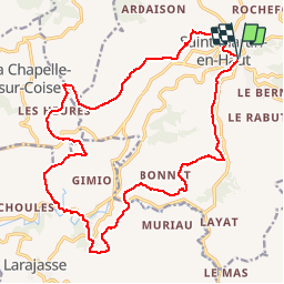
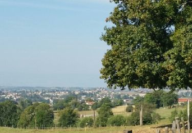
Tocht Stappen van 22 km beschikbaar op Auvergne-Rhône-Alpes, Rhône, Saint-Martin-en-Haut. Deze tocht wordt voorgesteld door tracegps.
Beschrijving
Randonnée organisée par le club de cyclo St Martinois. Circuit aux alentours de St Martin le Haut dans les Monts du Lyonnais.
Plaatsbepaling
Land:
France
Regio :
Auvergne-Rhône-Alpes
Departement/Provincie :
Rhône
Gemeente :
Saint-Martin-en-Haut
Locatie:
Unknown
Vertrek:(Dec)
Vertrek:(UTM)
621866 ; 5057267 (31T) N.
Opmerkingen
Wandeltochten in de omgeving
![Tocht Mountainbike Saint-Martin-en-Haut - 19ème Croisée des Monts du Lyonnais (2012-VTT-25km) / Saint-Martin-en-Haut - Photo](https://media.geolcdn.com/t/375/260/ext.jpg?maxdim=2&url=https%3A%2F%2Fservices.sitytrail.com%2FGeolivesWS%2FDownloadMedia.ashx%3FTrailID%3D129837%26Media%3D13390_6.jpg)
![Mountainbike Mountainbike](https://static1.geolcdn.com/sitytour/trail-icons/202.png)
19ème Croisée des Monts du Lyonnais (2012-VTT-25km) / Saint-Martin-en-Haut
Mountainbike
Medium
(1)
Saint-Martin-en-Haut,
Auvergne-Rhône-Alpes,
Rhône,
France
![](/images/other/stat-length.png)
25 km | 35 km-effort
2h 45min
![](https://static1.geolcdn.com/siteimages/upload/files/16400158638029165_repeat_loop_refresh_sync_direction_icon.png)
Ja
![Tocht Stappen Thurins - tour du bois du baron - Photo](https://media.geolcdn.com/t/375/260/ext.jpg?maxdim=2&url=https%3A%2F%2Fservices.sitytrail.com%2FGeolivesWS%2FDownloadMedia.ashx%3FTrailID%3D548394%26Media%3Dfix__20160403153341.jpg)
![Stappen Stappen](https://static1.geolcdn.com/sitytour/trail-icons/101.png)
tour du bois du baron
Stappen
Gemakkelijk
(3)
Thurins,
Auvergne-Rhône-Alpes,
Rhône,
France
![](/images/other/stat-length.png)
7,4 km | 11,5 km-effort
1h 40min
![](https://static1.geolcdn.com/siteimages/upload/files/16400158638029165_repeat_loop_refresh_sync_direction_icon.png)
Ja
![Tocht Stappen Duerne - Randonnée des collines autour de Duerne - Photo](https://media.geolcdn.com/t/375/260/56b3b5ff-8854-42cb-926b-a132b104089d.jpg&format=jpg&maxdim=2)
![Stappen Stappen](https://static1.geolcdn.com/sitytour/trail-icons/101.png)
Randonnée des collines autour de Duerne
Stappen
Medium
Duerne,
Auvergne-Rhône-Alpes,
Rhône,
France
![](/images/other/stat-length.png)
15,5 km | 22 km-effort
4h 2min
![](https://static1.geolcdn.com/siteimages/upload/files/16400158638029165_repeat_loop_refresh_sync_direction_icon.png)
Ja
![Tocht Stappen Saint-André-la-Côte - 69-st-andre-la cote-mattiole-20km-640m-mai22 - Photo](https://media.geolcdn.com/t/375/260/7a464e9e-07ad-49d2-9fc0-eab7bce1d3e5.jpg&format=jpg&maxdim=2)
![Stappen Stappen](https://static1.geolcdn.com/sitytour/trail-icons/101.png)
69-st-andre-la cote-mattiole-20km-640m-mai22
Stappen
Medium
Saint-André-la-Côte,
Auvergne-Rhône-Alpes,
Rhône,
France
![](/images/other/stat-length.png)
20 km | 29 km-effort
5h 56min
![](https://static1.geolcdn.com/siteimages/upload/files/16400158638029165_repeat_loop_refresh_sync_direction_icon.png)
Ja
![Tocht Stappen Saint-André-la-Côte - 69-St-andre-la-cote-Ste-catherine-14km-453m - Photo](https://media.geolcdn.com/t/375/260/06cb0992-8e16-4e77-b851-837722622855.jpg&format=jpg&maxdim=2)
![Stappen Stappen](https://static1.geolcdn.com/sitytour/trail-icons/101.png)
69-St-andre-la-cote-Ste-catherine-14km-453m
Stappen
Medium
Saint-André-la-Côte,
Auvergne-Rhône-Alpes,
Rhône,
France
![](/images/other/stat-length.png)
14,2 km | 20 km-effort
3h 48min
![](https://static1.geolcdn.com/siteimages/upload/files/16400158638029165_repeat_loop_refresh_sync_direction_icon.png)
Ja
![Tocht Te voet Saint-Martin-en-Haut - Circuit des Sources du Garon - Photo](https://media.geolcdn.com/t/375/260/fe014065-bc06-4e54-b660-6900e183f331.jpeg&format=jpg&maxdim=2)
![Te voet Te voet](https://static1.geolcdn.com/sitytour/trail-icons/100.png)
Circuit des Sources du Garon
Te voet
Medium
Saint-Martin-en-Haut,
Auvergne-Rhône-Alpes,
Rhône,
France
![](/images/other/stat-length.png)
15,7 km | 22 km-effort
5h 3min
![](https://static1.geolcdn.com/siteimages/upload/files/16400158638029165_repeat_loop_refresh_sync_direction_icon.png)
Ja
![Tocht Noords wandelen Saint-Martin-en-Haut - Quéser à St Symphonie sur Croise - Photo](https://media.geolcdn.com/t/375/260/ext.jpg?maxdim=2&url=https%3A%2F%2Fservices.sitytrail.com%2FGeolivesWS%2FDownloadMedia.ashx%3FTrailID%3D631037%26Media%3Dfix__20160913104438.jpg)
![Noords wandelen Noords wandelen](https://static1.geolcdn.com/sitytour/trail-icons/102.png)
Quéser à St Symphonie sur Croise
Noords wandelen
Gemakkelijk
Saint-Martin-en-Haut,
Auvergne-Rhône-Alpes,
Rhône,
France
![](/images/other/stat-length.png)
8,7 km | 11,3 km-effort
2h 38min
![](https://static1.geolcdn.com/siteimages/upload/files/16400158638029165_repeat_loop_refresh_sync_direction_icon.png)
Neen
![Tocht Noords wandelen Saint-Martin-en-Haut - St Martin en Haut à Duerne - Photo](https://media.geolcdn.com/t/375/260/ext.jpg?maxdim=2&url=https%3A%2F%2Fservices.sitytrail.com%2FGeolivesWS%2FDownloadMedia.ashx%3FTrailID%3D631033%26Media%3Dfix__20160914102310.jpg)
![Noords wandelen Noords wandelen](https://static1.geolcdn.com/sitytour/trail-icons/102.png)
St Martin en Haut à Duerne
Noords wandelen
Gemakkelijk
Saint-Martin-en-Haut,
Auvergne-Rhône-Alpes,
Rhône,
France
![](/images/other/stat-length.png)
14,8 km | 19,8 km-effort
5h 33min
![](https://static1.geolcdn.com/siteimages/upload/files/16400158638029165_repeat_loop_refresh_sync_direction_icon.png)
Ja
![Tocht Mountainbike Saint-Martin-en-Haut - Balade VTT à St Martin En Haut - Photo](https://media.geolcdn.com/t/375/260/ext.jpg?maxdim=2&url=https%3A%2F%2Fservices.sitytrail.com%2FGeolivesWS%2FDownloadMedia.ashx%3FTrailID%3D317424%26Media%3D16653_3.jpg)
![Mountainbike Mountainbike](https://static1.geolcdn.com/sitytour/trail-icons/202.png)
Balade VTT à St Martin En Haut
Mountainbike
Moeilijk
Saint-Martin-en-Haut,
Auvergne-Rhône-Alpes,
Rhône,
France
![](/images/other/stat-length.png)
25 km | 35 km-effort
2h 30min
![](https://static1.geolcdn.com/siteimages/upload/files/16400158638029165_repeat_loop_refresh_sync_direction_icon.png)
Ja