![](/images/other/stat-length.png)
![Tocht Stappen Sourdon - Autour d'Ainval - Sourdon - Photo](https://media.geolcdn.com/t/1900/400/ext.pjpeg?maxdim=2&url=https%3A%2F%2Fservices.sitytrail.com%2FGeolivesWS%2FDownloadMedia.ashx%3FTrailID%3D316957%26Media%3D16075_4.jpg)
Autour d'Ainval - Sourdon
tracegps
Gebruiker
![Lengte](/images/other/stat-length.png)
Lengte
10,4 km
![Max. hoogte](https://static1.geolcdn.com/siteimages/upload/files/1508320355ic_sort_altitude_max_24dp.png)
Max. hoogte
142 m
![Positief hoogteverschil](https://static1.geolcdn.com/siteimages/upload/files/1508320355ic_sort_den_pos_24dp.png)
Positief hoogteverschil
142 m
![Km-Effort](/images/other/stat-length.png)
Km-Effort
12,3 km
![Min. hoogte](https://static1.geolcdn.com/siteimages/upload/files/1508320355ic_sort_altitude_min_24dp.png)
Min. hoogte
75 m
![Negatief hoogteverschil](https://static1.geolcdn.com/siteimages/upload/files/1508320355ic_sort_den_neg_24dp.png)
Negatief hoogteverschil
142 m
![Boucle](https://static1.geolcdn.com/siteimages/upload/files/16400158638029165_repeat_loop_refresh_sync_direction_icon.png)
Boucle
Ja
Datum van aanmaak :
2014-12-10 00:00:00.0
Laatste wijziging :
2014-12-10 00:00:00.0
![Stappen](https://static1.geolcdn.com/sitytour/trail-icons/101.png)
3h00
Moeilijkheid : Medium
![Scan deze QR-code om de tocht te openen in de SityTrail-applicatie](https://capi.geolives.com/qq0zvz2zws4bq2lad0pu/sitytour/trails/316957/qr.png?size=200)
Gratisgps-wandelapplicatie
Over ons
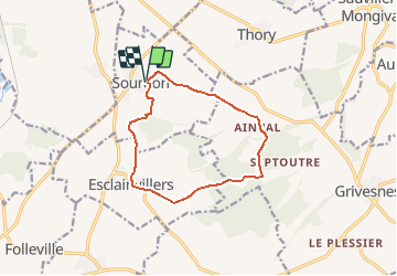
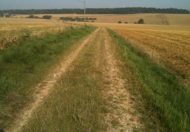
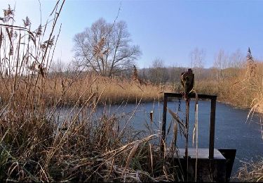
Tocht Stappen van 10,4 km beschikbaar op Hauts-de-France, Somme, Sourdon. Deze tocht wordt voorgesteld door tracegps.
Beschrijving
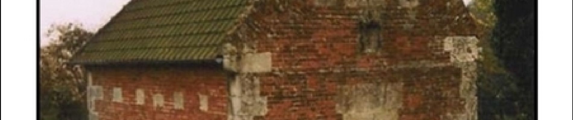
Départ de l'église de Sourdon vers Ainval. Le précieux bras reliquaire de saint Fiacre, vous indique le chemin du retour depuis l'église d'Esclainvillers. Retrouvez cette randonnée sur le site de l'Office de Tourisme de Val de Noye.
Plaatsbepaling
Land:
France
Regio :
Hauts-de-France
Departement/Provincie :
Somme
Gemeente :
Sourdon
Locatie:
Unknown
Vertrek:(Dec)
Vertrek:(UTM)
456702 ; 5506554 (31U) N.
Opmerkingen
Wandeltochten in de omgeving
![Tocht Stappen Ailly-sur-Noye - Bois de Berny - Photo](https://media.geolcdn.com/t/375/260/ext.jpg?maxdim=2&url=https%3A%2F%2Fstatic1.geolcdn.com%2Fsiteimages%2Fupload%2Ffiles%2F1553511878bg_sport_marche.png)
![Stappen Stappen](https://static1.geolcdn.com/sitytour/trail-icons/101.png)
Bois de Berny
Stappen
Medium
(1)
Ailly-sur-Noye,
Hauts-de-France,
Somme,
France
![](/images/other/stat-length.png)
10,1 km | 12,1 km-effort
2h 38min
![](https://static1.geolcdn.com/siteimages/upload/files/16400158638029165_repeat_loop_refresh_sync_direction_icon.png)
Ja
![Tocht Stappen Grivesnes - Le Langueron - Grivesnes - Photo](https://media.geolcdn.com/t/375/260/ext.jpg?maxdim=2&url=https%3A%2F%2Fservices.sitytrail.com%2FGeolivesWS%2FDownloadMedia.ashx%3FTrailID%3D316906%26Media%3D16004_6.jpg)
![Stappen Stappen](https://static1.geolcdn.com/sitytour/trail-icons/101.png)
Le Langueron - Grivesnes
Stappen
Medium
Grivesnes,
Hauts-de-France,
Somme,
France
![](/images/other/stat-length.png)
13,2 km | 15,6 km-effort
2h 15min
![](https://static1.geolcdn.com/siteimages/upload/files/16400158638029165_repeat_loop_refresh_sync_direction_icon.png)
Ja
![Tocht Mountainbike Ailly-sur-Noye - Circuit n° 4 VTT - Ailly-sur-Noye - Photo](https://media.geolcdn.com/t/375/260/ext.jpg?maxdim=2&url=https%3A%2F%2Fservices.sitytrail.com%2FGeolivesWS%2FDownloadMedia.ashx%3FTrailID%3D111125%26Media%3D6480_2.jpg)
![Mountainbike Mountainbike](https://static1.geolcdn.com/sitytour/trail-icons/202.png)
Circuit n° 4 VTT - Ailly-sur-Noye
Mountainbike
Moeilijk
Ailly-sur-Noye,
Hauts-de-France,
Somme,
France
![](/images/other/stat-length.png)
42 km | 50 km-effort
4h 0min
![](https://static1.geolcdn.com/siteimages/upload/files/16400158638029165_repeat_loop_refresh_sync_direction_icon.png)
Ja
![Tocht Fiets Ailly-sur-Noye - Le Val de Noye - Boucle de Boves - Photo](https://media.geolcdn.com/t/375/260/ext.jpg?maxdim=2&url=https%3A%2F%2Fservices.sitytrail.com%2FGeolivesWS%2FDownloadMedia.ashx%3FTrailID%3D109972%26Media%3D5053_1.jpg)
![Fiets Fiets](https://static1.geolcdn.com/sitytour/trail-icons/200.png)
Le Val de Noye - Boucle de Boves
Fiets
Medium
Ailly-sur-Noye,
Hauts-de-France,
Somme,
France
![](/images/other/stat-length.png)
27 km | 30 km-effort
1h 30min
![](https://static1.geolcdn.com/siteimages/upload/files/16400158638029165_repeat_loop_refresh_sync_direction_icon.png)
Ja
![Tocht Fiets Ailly-sur-Noye - Le Val de Noye - Boucle de Coullemelle - Photo](https://media.geolcdn.com/t/375/260/ext.jpg?maxdim=2&url=https%3A%2F%2Fservices.sitytrail.com%2FGeolivesWS%2FDownloadMedia.ashx%3FTrailID%3D109971%26Media%3D5052_1.jpg)
![Fiets Fiets](https://static1.geolcdn.com/sitytour/trail-icons/200.png)
Le Val de Noye - Boucle de Coullemelle
Fiets
Medium
Ailly-sur-Noye,
Hauts-de-France,
Somme,
France
![](/images/other/stat-length.png)
33 km | 38 km-effort
2h 0min
![](https://static1.geolcdn.com/siteimages/upload/files/16400158638029165_repeat_loop_refresh_sync_direction_icon.png)
Ja
![Tocht Stappen Folleville - Folleville - Photo](https://media.geolcdn.com/t/375/260/ext.jpg?maxdim=2&url=https%3A%2F%2Fstatic1.geolcdn.com%2Fsiteimages%2Fupload%2Ffiles%2F1553511878bg_sport_marche.png)
![Stappen Stappen](https://static1.geolcdn.com/sitytour/trail-icons/101.png)
Folleville
Stappen
Heel gemakkelijk
Folleville,
Hauts-de-France,
Somme,
France
![](/images/other/stat-length.png)
6,1 km | 7,5 km-effort
1h 25min
![](https://static1.geolcdn.com/siteimages/upload/files/16400158638029165_repeat_loop_refresh_sync_direction_icon.png)
Ja
![Tocht Stappen Chirmont - Johnny - Photo](https://media.geolcdn.com/t/375/260/eb94b8e5-d772-4844-91a8-8dfb82f48b11.jpg&format=jpg&maxdim=2)
![Stappen Stappen](https://static1.geolcdn.com/sitytour/trail-icons/101.png)
Johnny
Stappen
Gemakkelijk
Chirmont,
Hauts-de-France,
Somme,
France
![](/images/other/stat-length.png)
9,6 km | 11,1 km-effort
1h 57min
![](https://static1.geolcdn.com/siteimages/upload/files/16400158638029165_repeat_loop_refresh_sync_direction_icon.png)
Ja
![Tocht sport Ailly-sur-Noye - Benny - Photo](https://media.geolcdn.com/t/375/260/ext.jpg?maxdim=2&url=https%3A%2F%2Fsecurestorage.geolives.com%2Fsitytour%2Ftrail-bg%2Fdefault.jpg)
Benny
sport
Heel gemakkelijk
Ailly-sur-Noye,
Hauts-de-France,
Somme,
France
![](/images/other/stat-length.png)
9,8 km | 11,7 km-effort
Onbekend
![](https://static1.geolcdn.com/siteimages/upload/files/16400158638029165_repeat_loop_refresh_sync_direction_icon.png)
Ja
![Tocht Lopen Sourdon - sourdon ainval - Photo](https://media.geolcdn.com/t/375/260/ext.jpg?maxdim=2&url=https%3A%2F%2Fstatic1.geolcdn.com%2Fsiteimages%2Fupload%2Ffiles%2F1524743154running.jpg)
![Lopen Lopen](https://static1.geolcdn.com/sitytour/trail-icons/103.png)
sourdon ainval
Lopen
Heel gemakkelijk
Sourdon,
Hauts-de-France,
Somme,
France
![](/images/other/stat-length.png)
11,1 km | 13,6 km-effort
1h 20min
![](https://static1.geolcdn.com/siteimages/upload/files/16400158638029165_repeat_loop_refresh_sync_direction_icon.png)
Ja