![](/images/other/stat-length.png)
![Tocht Stappen Philippsbourg - Hanau Falkenstein Waldeck - Photo](https://media.geolcdn.com/t/1900/400/ext.pjpeg?maxdim=2&url=https%3A%2F%2Fservices.sitytrail.com%2FGeolivesWS%2FDownloadMedia.ashx%3FTrailID%3D316910%26Media%3D16009_6.jpg)
Hanau Falkenstein Waldeck
tracegps
Gebruiker
![Lengte](/images/other/stat-length.png)
![Max. hoogte](https://static1.geolcdn.com/siteimages/upload/files/1508320355ic_sort_altitude_max_24dp.png)
![Positief hoogteverschil](https://static1.geolcdn.com/siteimages/upload/files/1508320355ic_sort_den_pos_24dp.png)
![Km-Effort](/images/other/stat-length.png)
![Min. hoogte](https://static1.geolcdn.com/siteimages/upload/files/1508320355ic_sort_altitude_min_24dp.png)
![Negatief hoogteverschil](https://static1.geolcdn.com/siteimages/upload/files/1508320355ic_sort_den_neg_24dp.png)
![Boucle](https://static1.geolcdn.com/siteimages/upload/files/16400158638029165_repeat_loop_refresh_sync_direction_icon.png)
![Stappen](https://static1.geolcdn.com/sitytour/trail-icons/101.png)
4h30
Moeilijkheid : Medium
![Scan deze QR-code om de tocht te openen in de SityTrail-applicatie](https://capi.geolives.com/qq0zvz2zws4bq2lad0pu/sitytour/trails/316910/qr.png?size=200)
Gratisgps-wandelapplicatie
Over ons
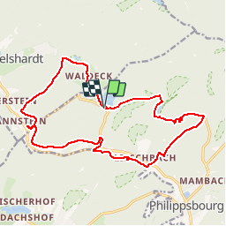
Tocht Stappen van 18,1 km beschikbaar op Grand Est, Moselle, Philippsbourg. Deze tocht wordt voorgesteld door tracegps.
Beschrijving
Départ parking de l’étang de Hanau. Suivre le circuit balisé croix bleue vers le col du Kachler, étang de Lieschbach, et montée vers le château du Falkenstein. Visiter les ruines et monter jusqu’à la table panoramique au point le plus haut du château. Revenir sur ses pas et continuer sur le balisage croix bleue. Quitter le circuit balisé et continuer direction Sud-ouest pour rejoindre le balisage triangle jaune. Au hameau de Lieschbach, traverser avec prudence la D662 et continuer sur balisage rectangle jaune-blanc-jaune le long du Falkensteinerbach, rive droite. Traverser de nouveau la D662, sur rectangle jaune, et quitter le chemin balisé pour longer le Falkensteinerbach rive gauche jusqu’à l’étang du Bleiweiher. Toujours sur le chemin non balisé, continuer direction Nord-Est vers l’étang de Waldeck. Monter à la ruine du château de Waldeck. Continuer sur le chemin balisé rectangle jaune vers le hameau de Waldeck, traverser la route forestière des Bornes, visiter la tourbière et rejoindre l’étang de Hanau.
Plaatsbepaling
Opmerkingen
Wandeltochten in de omgeving
![Tocht Stappen Éguelshardt - Notre Dame des Bois - Photo](https://media.geolcdn.com/t/375/260/3cf87b27-a59c-4ea6-a7bf-d652826f7266.jpg&format=jpg&maxdim=2)
![Stappen Stappen](https://static1.geolcdn.com/sitytour/trail-icons/101.png)
Stappen
![](/images/other/stat-length.png)
![](https://static1.geolcdn.com/siteimages/upload/files/16400158638029165_repeat_loop_refresh_sync_direction_icon.png)
![Tocht Stappen Philippsbourg - Les 3 châteaux : Falkenstein, Rothenbourg, Waldeck - Photo](https://media.geolcdn.com/t/375/260/ext.jpg?maxdim=2&url=https%3A%2F%2Fservices.sitytrail.com%2FGeolivesWS%2FDownloadMedia.ashx%3FTrailID%3D118668%26Media%3D12831_5.jpg)
![Stappen Stappen](https://static1.geolcdn.com/sitytour/trail-icons/101.png)
Stappen
![](/images/other/stat-length.png)
![](https://static1.geolcdn.com/siteimages/upload/files/16400158638029165_repeat_loop_refresh_sync_direction_icon.png)
![Tocht Te voet Philippsbourg - Yellow X - Photo](https://media.geolcdn.com/t/375/260/405334b8-fc9f-4697-8248-e0a1e7aa1239.jpeg&format=jpg&maxdim=2)
![Te voet Te voet](https://static1.geolcdn.com/sitytour/trail-icons/100.png)
Te voet
![](/images/other/stat-length.png)
![](https://static1.geolcdn.com/siteimages/upload/files/16400158638029165_repeat_loop_refresh_sync_direction_icon.png)
![Tocht Te voet Philippsbourg - Red dot - Photo](https://media.geolcdn.com/t/375/260/41711dff-01c3-4002-aacf-819b06d7da02.jpeg&format=jpg&maxdim=2)
![Te voet Te voet](https://static1.geolcdn.com/sitytour/trail-icons/100.png)
Te voet
![](/images/other/stat-length.png)
![](https://static1.geolcdn.com/siteimages/upload/files/16400158638029165_repeat_loop_refresh_sync_direction_icon.png)
![Tocht Te voet Philippsbourg - Red triangle - Photo](https://media.geolcdn.com/t/375/260/41711dff-01c3-4002-aacf-819b06d7da02.jpeg&format=jpg&maxdim=2)
![Te voet Te voet](https://static1.geolcdn.com/sitytour/trail-icons/100.png)
Te voet
![](/images/other/stat-length.png)
![](https://static1.geolcdn.com/siteimages/upload/files/16400158638029165_repeat_loop_refresh_sync_direction_icon.png)
![Tocht Te voet Baerenthal - Yellow ring - Photo](https://media.geolcdn.com/t/375/260/c97fa14f-913f-4d0c-9e00-fb1aec3cafd9.jpeg&format=jpg&maxdim=2)
![Te voet Te voet](https://static1.geolcdn.com/sitytour/trail-icons/100.png)
Te voet
![](/images/other/stat-length.png)
![](https://static1.geolcdn.com/siteimages/upload/files/16400158638029165_repeat_loop_refresh_sync_direction_icon.png)
![Tocht Te voet Philippsbourg - Sentier Goldenberg - Photo](https://media.geolcdn.com/t/375/260/6348f4f6-901a-4514-89c9-fdb6087d121c.jpeg&format=jpg&maxdim=2)
![Te voet Te voet](https://static1.geolcdn.com/sitytour/trail-icons/100.png)
Te voet
![](/images/other/stat-length.png)
![](https://static1.geolcdn.com/siteimages/upload/files/16400158638029165_repeat_loop_refresh_sync_direction_icon.png)
![Tocht Te voet Philippsbourg - Yellow cross - Photo](https://media.geolcdn.com/t/375/260/fff2d3ea-92b0-447d-8719-9088e8932805.jpeg&format=jpg&maxdim=2)
![Te voet Te voet](https://static1.geolcdn.com/sitytour/trail-icons/100.png)
Te voet
![](/images/other/stat-length.png)
![](https://static1.geolcdn.com/siteimages/upload/files/16400158638029165_repeat_loop_refresh_sync_direction_icon.png)
![Tocht Te voet Philippsbourg - Blue dot - Photo](https://media.geolcdn.com/t/375/260/405334b8-fc9f-4697-8248-e0a1e7aa1239.jpeg&format=jpg&maxdim=2)
![Te voet Te voet](https://static1.geolcdn.com/sitytour/trail-icons/100.png)
Te voet
![](/images/other/stat-length.png)
![](https://static1.geolcdn.com/siteimages/upload/files/16400158638029165_repeat_loop_refresh_sync_direction_icon.png)