![](/images/other/stat-length.png)
![Tocht Stappen Locmariaquer - Locmariaquer et ses sites naturels - Photo](https://media.geolcdn.com/t/1900/400/ext.pjpeg?maxdim=2&url=https%3A%2F%2Fservices.sitytrail.com%2FGeolivesWS%2FDownloadMedia.ashx%3FTrailID%3D316854%26Media%3D15924_5.jpg)
Locmariaquer et ses sites naturels
tracegps
Gebruiker
![Lengte](/images/other/stat-length.png)
Lengte
10,7 km
![Max. hoogte](https://static1.geolcdn.com/siteimages/upload/files/1508320355ic_sort_altitude_max_24dp.png)
Max. hoogte
14 m
![Positief hoogteverschil](https://static1.geolcdn.com/siteimages/upload/files/1508320355ic_sort_den_pos_24dp.png)
Positief hoogteverschil
54 m
![Km-Effort](/images/other/stat-length.png)
Km-Effort
11,4 km
![Min. hoogte](https://static1.geolcdn.com/siteimages/upload/files/1508320355ic_sort_altitude_min_24dp.png)
Min. hoogte
-1 m
![Negatief hoogteverschil](https://static1.geolcdn.com/siteimages/upload/files/1508320355ic_sort_den_neg_24dp.png)
Negatief hoogteverschil
54 m
![Boucle](https://static1.geolcdn.com/siteimages/upload/files/16400158638029165_repeat_loop_refresh_sync_direction_icon.png)
Boucle
Ja
Datum van aanmaak :
2014-12-10 00:00:00.0
Laatste wijziging :
2014-12-10 00:00:00.0
![Stappen](https://static1.geolcdn.com/sitytour/trail-icons/101.png)
2h45
Moeilijkheid : Medium
![Scan deze QR-code om de tocht te openen in de SityTrail-applicatie](https://capi.geolives.com/qq0zvz2zws4bq2lad0pu/sitytour/trails/316854/qr.png?size=200)
Gratisgps-wandelapplicatie
Over ons
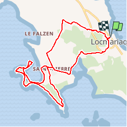
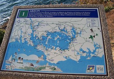
Tocht Stappen van 10,7 km beschikbaar op Bretagne, Morbihan, Locmariaquer. Deze tocht wordt voorgesteld door tracegps.
Beschrijving
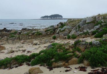
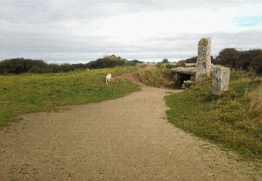
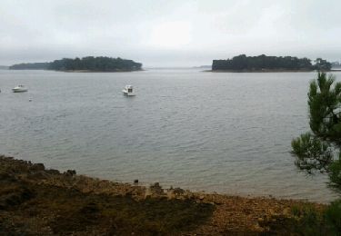
Départ de l’Office de Tourisme pour prendre la direction de Kerlud puis St-Pierre Lopéret. Vous passerez par les pointes d’Er Hourél et d’Er long ainsi que devant plusieurs sites mégalithiques. Retrouvez ce circuit sur le site de la commune de Locmariaquer.
Plaatsbepaling
Land:
France
Regio :
Bretagne
Departement/Provincie :
Morbihan
Gemeente :
Locmariaquer
Locatie:
Unknown
Vertrek:(Dec)
Vertrek:(UTM)
504074 ; 5268511 (30T) N.
Opmerkingen
Wandeltochten in de omgeving
![Tocht Stappen Locmariaquer - PR_56_Locmariaquer_AA_01_Circuit1b_Entre-Golfe-Et-Ocean_20220217 - Photo](https://media.geolcdn.com/t/375/260/eee1e160-7ef6-4c8d-9c67-f23fbc97fcb6.jpg&format=jpg&maxdim=2)
![Stappen Stappen](https://static1.geolcdn.com/sitytour/trail-icons/101.png)
PR_56_Locmariaquer_AA_01_Circuit1b_Entre-Golfe-Et-Ocean_20220217
Stappen
Heel gemakkelijk
(2)
Locmariaquer,
Bretagne,
Morbihan,
France
![](/images/other/stat-length.png)
8,5 km | 9,3 km-effort
1h 54min
![](https://static1.geolcdn.com/siteimages/upload/files/16400158638029165_repeat_loop_refresh_sync_direction_icon.png)
Ja
![Tocht Stappen Larmor-Baden - LARMOR-BADEN_PEN-EN-TOUL_BERDER - Photo](https://media.geolcdn.com/t/375/260/006d768a-8f9f-48de-b1ea-c2f886dc8e57.jpg&format=jpg&maxdim=2)
![Stappen Stappen](https://static1.geolcdn.com/sitytour/trail-icons/101.png)
LARMOR-BADEN_PEN-EN-TOUL_BERDER
Stappen
Gemakkelijk
(2)
Larmor-Baden,
Bretagne,
Morbihan,
France
![](/images/other/stat-length.png)
10,9 km | 12,3 km-effort
2h 23min
![](https://static1.geolcdn.com/siteimages/upload/files/16400158638029165_repeat_loop_refresh_sync_direction_icon.png)
Ja
![Tocht Stappen Locmariaquer - Le tour de Locmariaquer - Photo](https://media.geolcdn.com/t/375/260/ext.jpg?maxdim=2&url=https%3A%2F%2Fservices.sitytrail.com%2FGeolivesWS%2FDownloadMedia.ashx%3FTrailID%3D316851%26Media%3D15920_6.jpg)
![Stappen Stappen](https://static1.geolcdn.com/sitytour/trail-icons/101.png)
Le tour de Locmariaquer
Stappen
Medium
(1)
Locmariaquer,
Bretagne,
Morbihan,
France
![](/images/other/stat-length.png)
8,4 km | 9,2 km-effort
2h 30min
![](https://static1.geolcdn.com/siteimages/upload/files/16400158638029165_repeat_loop_refresh_sync_direction_icon.png)
Ja
![Tocht Stappen Locmariaquer - locmariaquer - Photo](https://media.geolcdn.com/t/375/260/ext.jpg?maxdim=2&url=https%3A%2F%2Fservices.sitytrail.com%2FGeolivesWS%2FDownloadMedia.ashx%3FTrailID%3D156625%26Media%3D20121004110915.jpeg)
![Stappen Stappen](https://static1.geolcdn.com/sitytour/trail-icons/101.png)
locmariaquer
Stappen
Gemakkelijk
(1)
Locmariaquer,
Bretagne,
Morbihan,
France
![](/images/other/stat-length.png)
7,2 km | 7,9 km-effort
1h 41min
![](https://static1.geolcdn.com/siteimages/upload/files/16400158638029165_repeat_loop_refresh_sync_direction_icon.png)
Ja
![Tocht Stappen Locmariaquer - Raid du Golfe du Morbihan - Photo](https://media.geolcdn.com/t/375/260/ext.jpg?maxdim=2&url=https%3A%2F%2Fservices.sitytrail.com%2FGeolivesWS%2FDownloadMedia.ashx%3FTrailID%3D109057%26Media%3D3072_3.jpg)
![Stappen Stappen](https://static1.geolcdn.com/sitytour/trail-icons/101.png)
Raid du Golfe du Morbihan
Stappen
Zeer moeilijk
(2)
Locmariaquer,
Bretagne,
Morbihan,
France
![](/images/other/stat-length.png)
177 km | 199 km-effort
44h 0min
![](https://static1.geolcdn.com/siteimages/upload/files/16400158638029165_repeat_loop_refresh_sync_direction_icon.png)
Neen
![Tocht Stappen Arzon - tour d'Arzon - Photo](https://media.geolcdn.com/t/375/260/8d2666dc-76b6-4531-82fb-267206fdbff7.jpg&format=jpg&maxdim=2)
![Stappen Stappen](https://static1.geolcdn.com/sitytour/trail-icons/101.png)
tour d'Arzon
Stappen
Gemakkelijk
(1)
Arzon,
Bretagne,
Morbihan,
France
![](/images/other/stat-length.png)
12,6 km | 14,1 km-effort
3h 19min
![](https://static1.geolcdn.com/siteimages/upload/files/16400158638029165_repeat_loop_refresh_sync_direction_icon.png)
Ja
![Tocht Lopen Larmor-Baden - Larmor Baden - Photo](https://media.geolcdn.com/t/375/260/ext.jpg?maxdim=2&url=https%3A%2F%2Fservices.sitytrail.com%2FGeolivesWS%2FDownloadMedia.ashx%3FTrailID%3D224679%26Media%3Dfix__20131001111052.jpg)
![Lopen Lopen](https://static1.geolcdn.com/sitytour/trail-icons/103.png)
Larmor Baden
Lopen
Medium
(1)
Larmor-Baden,
Bretagne,
Morbihan,
France
![](/images/other/stat-length.png)
5 km | 5,6 km-effort
54min
![](https://static1.geolcdn.com/siteimages/upload/files/16400158638029165_repeat_loop_refresh_sync_direction_icon.png)
Ja
![Tocht Stappen Arzon - Tour du Golfe du Morbihan - 01 - Arzon - Photo](https://media.geolcdn.com/t/375/260/ext.jpg?maxdim=2&url=https%3A%2F%2Fservices.sitytrail.com%2FGeolivesWS%2FDownloadMedia.ashx%3FTrailID%3D109031%26Media%3D2997_2.jpg)
![Stappen Stappen](https://static1.geolcdn.com/sitytour/trail-icons/101.png)
Tour du Golfe du Morbihan - 01 - Arzon
Stappen
Medium
(1)
Arzon,
Bretagne,
Morbihan,
France
![](/images/other/stat-length.png)
18,9 km | 21 km-effort
4h 0min
![](https://static1.geolcdn.com/siteimages/upload/files/16400158638029165_repeat_loop_refresh_sync_direction_icon.png)
Neen
![Tocht Stappen Arzon - Tour du Golfe - Arzon - Photo](https://media.geolcdn.com/t/375/260/ext.jpg?maxdim=2&url=https%3A%2F%2Fservices.sitytrail.com%2FGeolivesWS%2FDownloadMedia.ashx%3FTrailID%3D107071%26Media%3D11890_2.jpg)
![Stappen Stappen](https://static1.geolcdn.com/sitytour/trail-icons/101.png)
Tour du Golfe - Arzon
Stappen
Medium
(1)
Arzon,
Bretagne,
Morbihan,
France
![](/images/other/stat-length.png)
18,2 km | 20 km-effort
4h 30min
![](https://static1.geolcdn.com/siteimages/upload/files/16400158638029165_repeat_loop_refresh_sync_direction_icon.png)
Ja
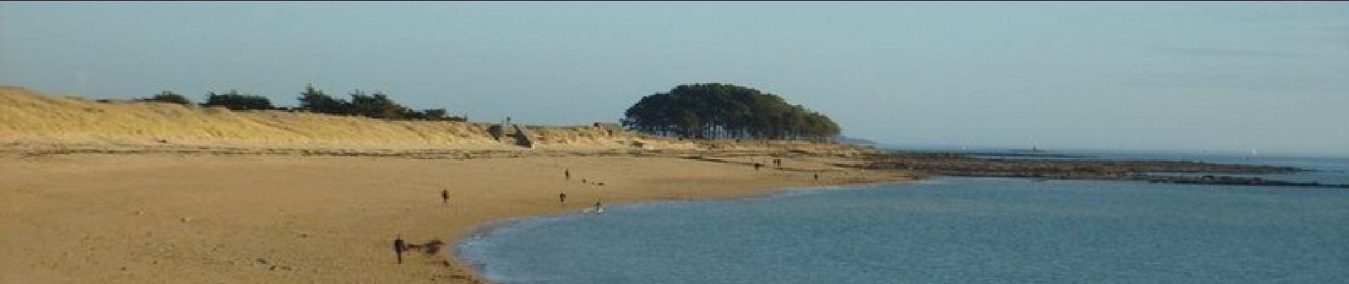
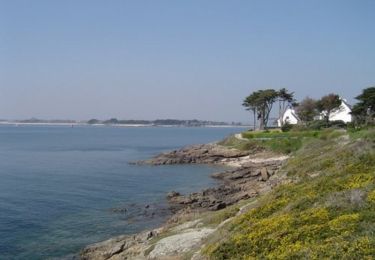
très jolie boucle, notamment sur la presqu'île