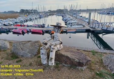
![](/images/other/stat-length.png)
![Tocht Stappen Plouguerneau - GR 34® de Keridaouen (Aber Wrac'h) au pont de l'Aber Benoît - Photo](https://media.geolcdn.com/t/1900/400/ext.pjpeg?maxdim=2&url=https%3A%2F%2Fservices.sitytrail.com%2FGeolivesWS%2FDownloadMedia.ashx%3FTrailID%3D316779%26Media%3D5185_1.jpg)
GR 34® de Keridaouen (Aber Wrac'h) au pont de l'Aber Benoît
tracegps
Gebruiker
![Lengte](/images/other/stat-length.png)
![Max. hoogte](https://static1.geolcdn.com/siteimages/upload/files/1508320355ic_sort_altitude_max_24dp.png)
![Positief hoogteverschil](https://static1.geolcdn.com/siteimages/upload/files/1508320355ic_sort_den_pos_24dp.png)
![Km-Effort](/images/other/stat-length.png)
![Min. hoogte](https://static1.geolcdn.com/siteimages/upload/files/1508320355ic_sort_altitude_min_24dp.png)
![Negatief hoogteverschil](https://static1.geolcdn.com/siteimages/upload/files/1508320355ic_sort_den_neg_24dp.png)
![Boucle](https://static1.geolcdn.com/siteimages/upload/files/16400158638029165_repeat_loop_refresh_sync_direction_icon.png)
![Stappen](https://static1.geolcdn.com/sitytour/trail-icons/101.png)
7h00
Moeilijkheid : Zeer moeilijk
![Scan deze QR-code om de tocht te openen in de SityTrail-applicatie](https://capi.geolives.com/qq0zvz2zws4bq2lad0pu/sitytour/trails/316779/qr.png?size=200)
Gratisgps-wandelapplicatie
Over ons
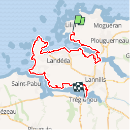
Tocht Stappen van 34 km beschikbaar op Bretagne, Finistère, Plouguerneau. Deze tocht wordt voorgesteld door tracegps.
Beschrijving
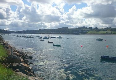
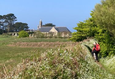
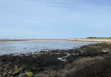
GR 34® de Keridaouen (Aber Wrac'h) au pont de l'Aber Benoît. L'Aber-Benoît se trouve entre l'Aber-Wrac'h et l'Aber-Ildut. Long de 31 km[1], il longe les communes de Lannilis, Tréglonou, Saint Pabu, Landéda et Plabennec. Le nom de l'Aber Benoît résulterait d'une mauvaise traduction du breton aber beniguet ou aber beni, appellation trouvant son origine dans la création, au VIe siècle, par Tudgibus et son fils Majan de deux oratoires de part et d'autre de l'aber, à Lothunou et Loc Majan. La plus grande partie de l'Aber-Benoît est un aber ou ria, une sorte de fjord. Ce bassin est long de 12 km et a une superficie de 140 km². C'est une zone propice à l'élevage ostréicole grâce à la présence de nombreux planctons nourriciers. (source Wikipédia) Vous trouverez le descriptif détaillé de cette randonnée dans le Topo-guide® de la Fédération Française de la Randonnée Pédestre. Le découpage proposé ici est donné à titre indicatif pour équilibrer la distance de chaque tronçon. Chacun peut l’adapter à son niveau. Pour toute information complémentaire sur la randonnée: Comité départemental du Finistère: 4 ROUTE DE ST RENAN BP 02 29810 PLOUARZEL Tél. : 0298896006
Plaatsbepaling
Opmerkingen
Wandeltochten in de omgeving
![Tocht Stappen Plouguerneau - Boucle Lilia - Perros - Photo](https://media.geolcdn.com/t/375/260/ext.jpg?maxdim=2&url=https%3A%2F%2Fservices.sitytrail.com%2FGeolivesWS%2FDownloadMedia.ashx%3FTrailID%3D462854%26Media%3Dfix__20150823120806.jpg)
![Stappen Stappen](https://static1.geolcdn.com/sitytour/trail-icons/101.png)
Stappen
![](/images/other/stat-length.png)
![](https://static1.geolcdn.com/siteimages/upload/files/16400158638029165_repeat_loop_refresh_sync_direction_icon.png)
![Tocht Stappen Plouguerneau - La tête de l'île - Photo](https://media.geolcdn.com/t/375/260/b43884a9-7f38-4fbc-8e53-86aa4116e8f9.jpg&format=jpg&maxdim=2)
![Stappen Stappen](https://static1.geolcdn.com/sitytour/trail-icons/101.png)
Stappen
![](/images/other/stat-length.png)
![](https://static1.geolcdn.com/siteimages/upload/files/16400158638029165_repeat_loop_refresh_sync_direction_icon.png)
![Tocht Stappen Landéda - 06.09.24 Landéda -- Treglonou (Touzilit) - Photo](https://media.geolcdn.com/t/375/260/ec11815a-c8fb-467a-9689-1ba3e69aa97c.jpg&format=jpg&maxdim=2)
![Stappen Stappen](https://static1.geolcdn.com/sitytour/trail-icons/101.png)
Stappen
![](/images/other/stat-length.png)
![](https://static1.geolcdn.com/siteimages/upload/files/16400158638029165_repeat_loop_refresh_sync_direction_icon.png)
![Tocht Stappen Plouguerneau - 05.09.23 Lilia -- Landéda - Photo](https://media.geolcdn.com/t/375/260/c7c06625-49c8-4c0c-abbd-b4fc835862db.jpg&format=jpg&maxdim=2)
![Stappen Stappen](https://static1.geolcdn.com/sitytour/trail-icons/101.png)
Stappen
![](/images/other/stat-length.png)
![](https://static1.geolcdn.com/siteimages/upload/files/16400158638029165_repeat_loop_refresh_sync_direction_icon.png)
![Tocht Fietstoerisme Plouguerneau - St Michel à St Pabu - Photo](https://media.geolcdn.com/t/375/260/20ce82cb-3f5c-494c-b024-433b8cba4612.jpg&format=jpg&maxdim=2)
![Fietstoerisme Fietstoerisme](https://static1.geolcdn.com/sitytour/trail-icons/204.png)
Fietstoerisme
![](/images/other/stat-length.png)
![](https://static1.geolcdn.com/siteimages/upload/files/16400158638029165_repeat_loop_refresh_sync_direction_icon.png)
![Tocht Stappen Landéda - AberWrac'h - Traon Bizin - 4km - Photo](https://media.geolcdn.com/t/375/260/ext.jpg?maxdim=2&url=https%3A%2F%2Fstatic1.geolcdn.com%2Fsiteimages%2Fupload%2Ffiles%2F1553511878bg_sport_marche.png)
![Stappen Stappen](https://static1.geolcdn.com/sitytour/trail-icons/101.png)
Stappen
![](/images/other/stat-length.png)
![](https://static1.geolcdn.com/siteimages/upload/files/16400158638029165_repeat_loop_refresh_sync_direction_icon.png)
![Tocht Stappen Landéda - Aberwac’h la dune (boucle) - Photo](https://media.geolcdn.com/t/375/260/e7189307-e1c4-4d36-a21c-92827b960ec1.jpg&format=jpg&maxdim=2)
![Stappen Stappen](https://static1.geolcdn.com/sitytour/trail-icons/101.png)
Stappen
![](/images/other/stat-length.png)
![](https://static1.geolcdn.com/siteimages/upload/files/16400158638029165_repeat_loop_refresh_sync_direction_icon.png)
![Tocht Te voet Landéda - Penn Enez ter - Photo](https://media.geolcdn.com/t/375/260/ext.jpg?maxdim=2&url=https%3A%2F%2Fstatic1.geolcdn.com%2Fsiteimages%2Fupload%2Ffiles%2F1545311037marcheuse_200dpi.jpg)
![Te voet Te voet](https://static1.geolcdn.com/sitytour/trail-icons/100.png)
Te voet
![](/images/other/stat-length.png)
![](https://static1.geolcdn.com/siteimages/upload/files/16400158638029165_repeat_loop_refresh_sync_direction_icon.png)
![Tocht sport Saint-Pabu - Évite - Photo](https://media.geolcdn.com/t/375/260/101fdcc4-fb1b-4fe5-9c4a-e5d4fec89aac.jpg&format=jpg&maxdim=2)
sport
![](/images/other/stat-length.png)
![](https://static1.geolcdn.com/siteimages/upload/files/16400158638029165_repeat_loop_refresh_sync_direction_icon.png)