![](/images/other/stat-length.png)
![Tocht Stappen Salazie - GR® R1 Le Tour du piton des Neiges - De Hell-Bourg à la Caverne Dufour - Photo](https://media.geolcdn.com/t/1900/400/ext.pjpeg?maxdim=2&url=https%3A%2F%2Fservices.sitytrail.com%2FGeolivesWS%2FDownloadMedia.ashx%3FTrailID%3D316761%26Media%3D4679_3.jpg)
GR® R1 Le Tour du piton des Neiges - De Hell-Bourg à la Caverne Dufour
tracegps
Gebruiker
![Lengte](/images/other/stat-length.png)
![Max. hoogte](https://static1.geolcdn.com/siteimages/upload/files/1508320355ic_sort_altitude_max_24dp.png)
![Positief hoogteverschil](https://static1.geolcdn.com/siteimages/upload/files/1508320355ic_sort_den_pos_24dp.png)
![Km-Effort](/images/other/stat-length.png)
![Min. hoogte](https://static1.geolcdn.com/siteimages/upload/files/1508320355ic_sort_altitude_min_24dp.png)
![Negatief hoogteverschil](https://static1.geolcdn.com/siteimages/upload/files/1508320355ic_sort_den_neg_24dp.png)
![Boucle](https://static1.geolcdn.com/siteimages/upload/files/16400158638029165_repeat_loop_refresh_sync_direction_icon.png)
![Stappen](https://static1.geolcdn.com/sitytour/trail-icons/101.png)
6h30
Moeilijkheid : Moeilijk
![Scan deze QR-code om de tocht te openen in de SityTrail-applicatie](https://capi.geolives.com/qq0zvz2zws4bq2lad0pu/sitytour/trails/316761/qr.png?size=200)
Gratisgps-wandelapplicatie
Over ons
Tocht Stappen van 12,1 km beschikbaar op Réunion, Onbekend, Salazie. Deze tocht wordt voorgesteld door tracegps.
Beschrijving
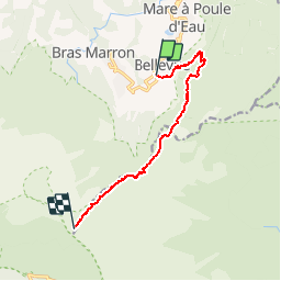
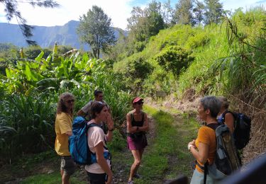
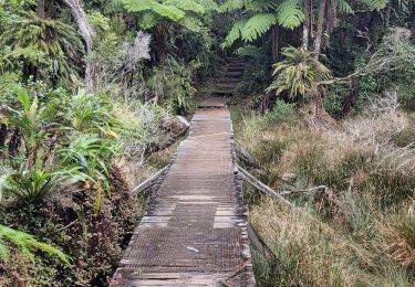
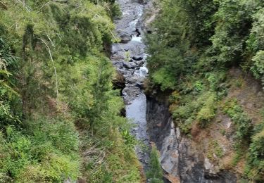
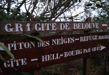
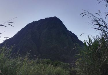
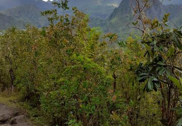
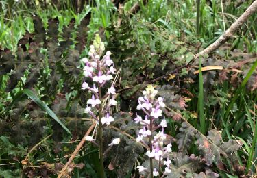
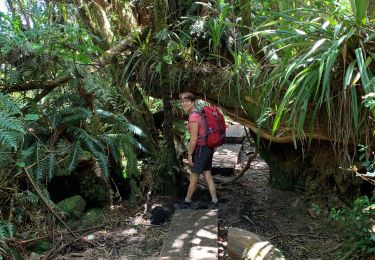
GR® R1 Le Tour du piton des Neiges Inauguré en 1979, le sentier de Grande Randonnée de la Réunion n°1 (GR R1), long d'une soixantaine de kilomètres, ceinture le Piton des Neiges et offre la possibilité de découvrir les trois cirques de l'île : Salazie, Cilaos et Mafate. Il permet d'accéder au plus haut sommet de l'île, le Piton des Neiges (3071 mètres). C'est donc un parcours dans le coeur de l'île. Le sentier sur un terrain accidenté est fait essentiellement de montées et descentes, parfois rudes. Il offre une palette de paysages grandioses : Col du Taïbit, Trois Roches, Plaine des Tamarins, Grand Sable, Bélouve, Cap Anglais, Piton des Neiges, Matarum… Le sentier GR® R1 est découpé en 6 étapes. Chacun est libre d’organiser son circuit en fonction du temps dont il dispose, de sa forme physique et de ses intérêts. Etape 1- De Hell-Bourg à la Caverne Dufour Attention après le gîte de Bélouve, il n’existe aucun point d’eau. Vous trouverez le descriptif détaillé de cette randonnée dans le Topo-guide® de la Fédération Française de la Randonnée Pédestre. Pour toute information complémentaire sur la randonnée : Comité départemental de la Réunion: 8 RUE DE LA CASERNE 9002 HLM CHIRICO PETITE ILE 97400 SAINT DENIS Tél. : 0262943706
Plaatsbepaling
Opmerkingen
Wandeltochten in de omgeving
![Tocht Stappen Salazie - mare à poules d'eau - Photo](https://media.geolcdn.com/t/375/260/f233e327-af89-4e51-8952-a42deb7b065c.jpg&format=jpg&maxdim=2)
![Stappen Stappen](https://static1.geolcdn.com/sitytour/trail-icons/101.png)
Stappen
![](/images/other/stat-length.png)
![](https://static1.geolcdn.com/siteimages/upload/files/16400158638029165_repeat_loop_refresh_sync_direction_icon.png)
![Tocht Stappen Salazie - Trou de Fer par le refuge de Belouve. - Photo](https://media.geolcdn.com/t/375/260/e928c1d8-2457-4a87-a207-09d9da2e6f6a.jpg&format=jpg&maxdim=2)
![Stappen Stappen](https://static1.geolcdn.com/sitytour/trail-icons/101.png)
Stappen
![](/images/other/stat-length.png)
![](https://static1.geolcdn.com/siteimages/upload/files/16400158638029165_repeat_loop_refresh_sync_direction_icon.png)
![Tocht Stappen Salazie - tour du piton maillot - rivière du mat - Photo](https://media.geolcdn.com/t/375/260/b0283353-1556-4e58-b3a9-10ea62f2ed93.jpg&format=jpg&maxdim=2)
![Stappen Stappen](https://static1.geolcdn.com/sitytour/trail-icons/101.png)
Stappen
![](/images/other/stat-length.png)
![](https://static1.geolcdn.com/siteimages/upload/files/16400158638029165_repeat_loop_refresh_sync_direction_icon.png)
![Tocht Te voet Salazie - Sentier du Trou de Fer - Photo](https://media.geolcdn.com/t/375/260/c038aaf4-d20f-42ab-9ddd-e2e145d6cf22.jpeg&format=jpg&maxdim=2)
![Te voet Te voet](https://static1.geolcdn.com/sitytour/trail-icons/100.png)
Te voet
![](/images/other/stat-length.png)
![](https://static1.geolcdn.com/siteimages/upload/files/16400158638029165_repeat_loop_refresh_sync_direction_icon.png)
![Tocht Stappen Salazie - Piton d'Anchain - Photo](https://media.geolcdn.com/t/375/260/e4fe93b2-c12b-4594-ba67-cfbaedd38e68.jpg&format=jpg&maxdim=2)
![Stappen Stappen](https://static1.geolcdn.com/sitytour/trail-icons/101.png)
Stappen
![](/images/other/stat-length.png)
![](https://static1.geolcdn.com/siteimages/upload/files/16400158638029165_repeat_loop_refresh_sync_direction_icon.png)
![Tocht Stappen Salazie - hellbourg trou de fer aller retour - Photo](https://media.geolcdn.com/t/375/260/f25ac1e5-8b40-471d-9124-c73c0cd498ae.jpg&format=jpg&maxdim=2)
![Stappen Stappen](https://static1.geolcdn.com/sitytour/trail-icons/101.png)
Stappen
![](/images/other/stat-length.png)
![](https://static1.geolcdn.com/siteimages/upload/files/16400158638029165_repeat_loop_refresh_sync_direction_icon.png)
![Tocht Stappen Saint-Benoît - Trou de fer 05/10/19 - Photo](https://media.geolcdn.com/t/375/260/e5527ee8-926b-48b9-9a90-e02a67c5d55f.jpg&format=jpg&maxdim=2)
![Stappen Stappen](https://static1.geolcdn.com/sitytour/trail-icons/101.png)
Stappen
![](/images/other/stat-length.png)
![](https://static1.geolcdn.com/siteimages/upload/files/16400158638029165_repeat_loop_refresh_sync_direction_icon.png)
![Tocht Stappen Salazie - Trpu de fer belouve depuis hellbourg - Photo](https://media.geolcdn.com/t/375/260/892a7e28-b4c3-43fd-a2b8-cc58d169f618.jpg&format=jpg&maxdim=2)
![Stappen Stappen](https://static1.geolcdn.com/sitytour/trail-icons/101.png)
Stappen
![](/images/other/stat-length.png)
![](https://static1.geolcdn.com/siteimages/upload/files/16400158638029165_repeat_loop_refresh_sync_direction_icon.png)
![Tocht Stappen Saint-Benoît - trou de fer - Photo](https://media.geolcdn.com/t/375/260/ext.jpg?maxdim=2&url=https%3A%2F%2Fservices.sitytrail.com%2FGeolivesWS%2FDownloadMedia.ashx%3FTrailID%3D398057%26Media%3Dfix__20150318134039.jpg)
![Stappen Stappen](https://static1.geolcdn.com/sitytour/trail-icons/101.png)
Stappen
![](/images/other/stat-length.png)
![](https://static1.geolcdn.com/siteimages/upload/files/16400158638029165_repeat_loop_refresh_sync_direction_icon.png)