![](/images/other/stat-length.png)
![Tocht Stappen Montillières-sur-Orne - La vallée de l'Orne - Thury Harcourt - Photo](https://media.geolcdn.com/t/1900/400/ext.pjpeg?maxdim=2&url=https%3A%2F%2Fservices.sitytrail.com%2FGeolivesWS%2FDownloadMedia.ashx%3FTrailID%3D316664%26Media%3D3748_2.jpg)
La vallée de l'Orne - Thury Harcourt
tracegps
Gebruiker
![Lengte](/images/other/stat-length.png)
Lengte
17,1 km
![Max. hoogte](https://static1.geolcdn.com/siteimages/upload/files/1508320355ic_sort_altitude_max_24dp.png)
Max. hoogte
135 m
![Positief hoogteverschil](https://static1.geolcdn.com/siteimages/upload/files/1508320355ic_sort_den_pos_24dp.png)
Positief hoogteverschil
421 m
![Km-Effort](/images/other/stat-length.png)
Km-Effort
23 km
![Min. hoogte](https://static1.geolcdn.com/siteimages/upload/files/1508320355ic_sort_altitude_min_24dp.png)
Min. hoogte
18 m
![Negatief hoogteverschil](https://static1.geolcdn.com/siteimages/upload/files/1508320355ic_sort_den_neg_24dp.png)
Negatief hoogteverschil
425 m
![Boucle](https://static1.geolcdn.com/siteimages/upload/files/16400158638029165_repeat_loop_refresh_sync_direction_icon.png)
Boucle
Ja
Datum van aanmaak :
2014-12-10 00:00:00.0
Laatste wijziging :
2014-12-10 00:00:00.0
![Stappen](https://static1.geolcdn.com/sitytour/trail-icons/101.png)
4h15
Moeilijkheid : Moeilijk
![Scan deze QR-code om de tocht te openen in de SityTrail-applicatie](https://capi.geolives.com/qq0zvz2zws4bq2lad0pu/sitytour/trails/316664/qr.png?size=200)
Gratisgps-wandelapplicatie
Over ons
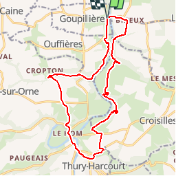
Tocht Stappen van 17,1 km beschikbaar op Normandië, Calvados, Montillières-sur-Orne. Deze tocht wordt voorgesteld door tracegps.
Beschrijving
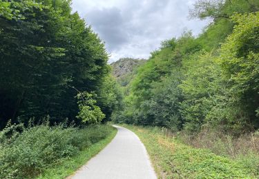
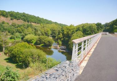
Au sud de Caen, l’Orne est très pittoresque. Ce circuit vous invite à en découvrir les deux rives au Nord de Thury Harcourt.
Plaatsbepaling
Land:
France
Regio :
Normandië
Departement/Provincie :
Calvados
Gemeente :
Montillières-sur-Orne
Locatie:
Goupillières
Vertrek:(Dec)
Vertrek:(UTM)
685106 ; 5434217 (30U) N.
Opmerkingen
Wandeltochten in de omgeving
![Tocht Mountainbike Montillières-sur-Orne - curcy trois monts - Photo](https://media.geolcdn.com/t/375/260/ext.jpg?maxdim=2&url=https%3A%2F%2Fstatic1.geolcdn.com%2Fsiteimages%2Fupload%2Ffiles%2F1524743154velo.jpg)
![Mountainbike Mountainbike](https://static1.geolcdn.com/sitytour/trail-icons/202.png)
curcy trois monts
Mountainbike
Medium
(1)
Montillières-sur-Orne,
Normandië,
Calvados,
France
![](/images/other/stat-length.png)
28 km | 35 km-effort
1h 59min
![](https://static1.geolcdn.com/siteimages/upload/files/16400158638029165_repeat_loop_refresh_sync_direction_icon.png)
Ja
![Tocht Te voet Le Hom - La Vallée de l'Orne - Photo](https://media.geolcdn.com/t/375/260/8002bbe4-56e1-4329-945e-78c51bb73184.jpeg&format=jpg&maxdim=2)
![Te voet Te voet](https://static1.geolcdn.com/sitytour/trail-icons/100.png)
La Vallée de l'Orne
Te voet
Medium
Le Hom,
Normandië,
Calvados,
France
![](/images/other/stat-length.png)
17,1 km | 23 km-effort
5h 10min
![](https://static1.geolcdn.com/siteimages/upload/files/16400158638029165_repeat_loop_refresh_sync_direction_icon.png)
Ja
![Tocht Te voet Espins - D'Espins au Moulin du traspy - Photo](https://media.geolcdn.com/t/375/260/6b452037-ce7a-42f3-8e30-05ba5c0eb969.jpeg&format=jpg&maxdim=2)
![Te voet Te voet](https://static1.geolcdn.com/sitytour/trail-icons/100.png)
D'Espins au Moulin du traspy
Te voet
Gemakkelijk
Espins,
Normandië,
Calvados,
France
![](/images/other/stat-length.png)
6,9 km | 9 km-effort
2h 3min
![](https://static1.geolcdn.com/siteimages/upload/files/16400158638029165_repeat_loop_refresh_sync_direction_icon.png)
Ja
![Tocht Stappen Maizet - COUDRAY 20 KM - Photo](https://media.geolcdn.com/t/375/260/ext.jpg?maxdim=2&url=https%3A%2F%2Fstatic1.geolcdn.com%2Fsiteimages%2Fupload%2Ffiles%2F1553511878bg_sport_marche.png)
![Stappen Stappen](https://static1.geolcdn.com/sitytour/trail-icons/101.png)
COUDRAY 20 KM
Stappen
Moeilijk
(2)
Maizet,
Normandië,
Calvados,
France
![](/images/other/stat-length.png)
19,8 km | 25 km-effort
5h 26min
![](https://static1.geolcdn.com/siteimages/upload/files/16400158638029165_repeat_loop_refresh_sync_direction_icon.png)
Ja
![Tocht Stappen Le Hom - le pont Hom (boucle) - Photo](https://media.geolcdn.com/t/375/260/ext.jpg?maxdim=2&url=https%3A%2F%2Fstatic1.geolcdn.com%2Fsiteimages%2Fupload%2Ffiles%2F1553511878bg_sport_marche.png)
![Stappen Stappen](https://static1.geolcdn.com/sitytour/trail-icons/101.png)
le pont Hom (boucle)
Stappen
Medium
(1)
Le Hom,
Normandië,
Calvados,
France
![](/images/other/stat-length.png)
12,1 km | 16 km-effort
2h 45min
![](https://static1.geolcdn.com/siteimages/upload/files/16400158638029165_repeat_loop_refresh_sync_direction_icon.png)
Ja
![Tocht Stappen Ouffières - ouffi - Photo](https://media.geolcdn.com/t/375/260/11703828-2ceb-45cd-a7e2-4a32994ac9c5.jpg&format=jpg&maxdim=2)
![Stappen Stappen](https://static1.geolcdn.com/sitytour/trail-icons/101.png)
ouffi
Stappen
Moeilijk
(1)
Ouffières,
Normandië,
Calvados,
France
![](/images/other/stat-length.png)
10 km | 12,7 km-effort
2h 34min
![](https://static1.geolcdn.com/siteimages/upload/files/16400158638029165_repeat_loop_refresh_sync_direction_icon.png)
Ja
![Tocht Wegfiets Montillières-sur-Orne - Voie verte suisse normande - Photo](https://media.geolcdn.com/t/375/260/d54537f7-cea8-4778-919a-3f896f987a93.jpg&format=jpg&maxdim=2)
![Wegfiets Wegfiets](https://static1.geolcdn.com/sitytour/trail-icons/201.png)
Voie verte suisse normande
Wegfiets
Gemakkelijk
Montillières-sur-Orne,
Normandië,
Calvados,
France
![](/images/other/stat-length.png)
47 km | 53 km-effort
4h 14min
![](https://static1.geolcdn.com/siteimages/upload/files/16400158638029165_repeat_loop_refresh_sync_direction_icon.png)
Ja
![Tocht Te voet Grimbosq - Moulin de Pray et Pont de Brie - Photo](https://media.geolcdn.com/t/375/260/4f00fc9e-b079-4935-aac2-5b457a76fd12.jpeg&format=jpg&maxdim=2)
![Te voet Te voet](https://static1.geolcdn.com/sitytour/trail-icons/100.png)
Moulin de Pray et Pont de Brie
Te voet
Gemakkelijk
Grimbosq,
Normandië,
Calvados,
France
![](/images/other/stat-length.png)
4,3 km | 4,9 km-effort
1h 6min
![](https://static1.geolcdn.com/siteimages/upload/files/16400158638029165_repeat_loop_refresh_sync_direction_icon.png)
Neen
![Tocht Stappen Mutrécy - Mutrecy - Photo](https://media.geolcdn.com/t/375/260/302b4fe3-8699-4129-8639-a9cf700582b9.jpg&format=jpg&maxdim=2)
![Stappen Stappen](https://static1.geolcdn.com/sitytour/trail-icons/101.png)
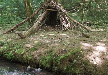
du plan d'eau de thury au dessus du camping impossible le sentier est en super pente et non entretenu ...