![](/images/other/stat-length.png)
![Tocht Stappen Saint-Ghislain - Hautrage Stambruges - Photo](https://media.geolcdn.com/t/1900/400/ext.pjpeg?maxdim=2&url=https%3A%2F%2Fstatic1.geolcdn.com%2Fsiteimages%2Fupload%2Ffiles%2F1553511878bg_sport_marche.png)
Hautrage Stambruges
FromHere
Gebruiker
![Lengte](/images/other/stat-length.png)
Lengte
8,8 km
![Max. hoogte](https://static1.geolcdn.com/siteimages/upload/files/1508320355ic_sort_altitude_max_24dp.png)
Max. hoogte
98 m
![Positief hoogteverschil](https://static1.geolcdn.com/siteimages/upload/files/1508320355ic_sort_den_pos_24dp.png)
Positief hoogteverschil
107 m
![Km-Effort](/images/other/stat-length.png)
Km-Effort
10,2 km
![Min. hoogte](https://static1.geolcdn.com/siteimages/upload/files/1508320355ic_sort_altitude_min_24dp.png)
Min. hoogte
48 m
![Negatief hoogteverschil](https://static1.geolcdn.com/siteimages/upload/files/1508320355ic_sort_den_neg_24dp.png)
Negatief hoogteverschil
110 m
![Boucle](https://static1.geolcdn.com/siteimages/upload/files/16400158638029165_repeat_loop_refresh_sync_direction_icon.png)
Boucle
Ja
Datum van aanmaak :
2022-03-12 08:26:28.689
Laatste wijziging :
2022-03-12 10:50:00.526
![Stappen](https://static1.geolcdn.com/sitytour/trail-icons/101.png)
2h23
Moeilijkheid : Gemakkelijk
![Scan deze QR-code om de tocht te openen in de SityTrail-applicatie](https://capi.geolives.com/qq0zvz2zws4bq2lad0pu/sitytour/trails/3163954/qr.png?size=200)
Gratisgps-wandelapplicatie
Over ons
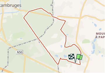
Tocht Stappen van 8,8 km beschikbaar op Wallonië, Henegouwen, Saint-Ghislain. Deze tocht wordt voorgesteld door FromHere.
Beschrijving
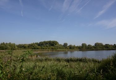
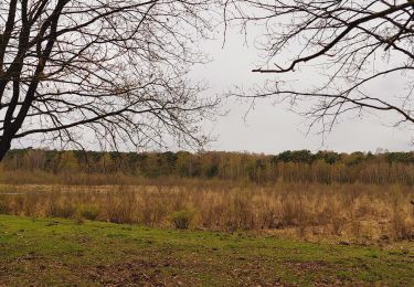
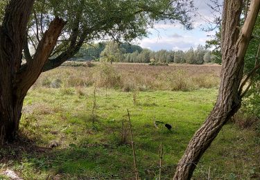
parcours boisé, idéal en été, peut être boueux à certains endroits, nombreuses mares, très chouette pour les chiens.
parcours facile
Plaatsbepaling
Land:
Belgium
Regio :
Wallonië
Departement/Provincie :
Henegouwen
Gemeente :
Saint-Ghislain
Locatie:
Unknown
Vertrek:(Dec)
Vertrek:(UTM)
553795 ; 5593030 (31U) N.
Opmerkingen
Wandeltochten in de omgeving
![Tocht Stappen Belœil - Chemin de la fontaine bouillante - Photo](https://media.geolcdn.com/t/375/260/ext.jpg?maxdim=2&url=https%3A%2F%2Fservices.sitytrail.com%2FGeolivesWS%2FDownloadMedia.ashx%3FTrailID%3D202870%26Media%3D66f0b4d7-30a6-4305-b894-706a5e0388ba.jpg)
![Stappen Stappen](https://static1.geolcdn.com/sitytour/trail-icons/101.png)
Chemin de la fontaine bouillante
Stappen
Heel gemakkelijk
(3)
Belœil,
Wallonië,
Henegouwen,
Belgium
![](/images/other/stat-length.png)
3,6 km | 4,2 km-effort
Onbekend
![](https://static1.geolcdn.com/siteimages/upload/files/16400158638029165_repeat_loop_refresh_sync_direction_icon.png)
Ja
![Tocht Stappen Belœil - Stambruges - Photo](https://media.geolcdn.com/t/375/260/845671f2-de57-446d-a443-835d16757d31.jpg&format=jpg&maxdim=2)
![Stappen Stappen](https://static1.geolcdn.com/sitytour/trail-icons/101.png)
Stambruges
Stappen
Heel gemakkelijk
(1)
Belœil,
Wallonië,
Henegouwen,
Belgium
![](/images/other/stat-length.png)
3 km | 3,3 km-effort
38min
![](https://static1.geolcdn.com/siteimages/upload/files/16400158638029165_repeat_loop_refresh_sync_direction_icon.png)
Neen
![Tocht Stappen Belœil - Beloeil - Circuit Natura 2000, des sites qui valent le détour - Ht06 - Photo](https://media.geolcdn.com/t/375/260/ext.jpg?maxdim=2&url=https%3A%2F%2Fservices.sitytrail.com%2FGeolivesWS%2FDownloadMedia.ashx%3FTrailID%3D356418%26Media%3D22e60fce-1fd7-4091-9907-7f7360a86d9d.JPG)
![Stappen Stappen](https://static1.geolcdn.com/sitytour/trail-icons/101.png)
Beloeil - Circuit Natura 2000, des sites qui valent le détour - Ht06
Stappen
Heel gemakkelijk
(4)
Belœil,
Wallonië,
Henegouwen,
Belgium
![](/images/other/stat-length.png)
3,5 km | 4 km-effort
51min
![](https://static1.geolcdn.com/siteimages/upload/files/16400158638029165_repeat_loop_refresh_sync_direction_icon.png)
Ja
![Tocht Noords wandelen Belœil - Mielikki marche nordique - Stambruges - Voeux 2024 - Photo](https://media.geolcdn.com/t/375/260/ext.jpg?maxdim=2&url=https%3A%2F%2Fstatic1.geolcdn.com%2Fsiteimages%2Fupload%2Ffiles%2F1545311037marcheuse_200dpi.jpg)
![Noords wandelen Noords wandelen](https://static1.geolcdn.com/sitytour/trail-icons/102.png)
Mielikki marche nordique - Stambruges - Voeux 2024
Noords wandelen
Medium
(1)
Belœil,
Wallonië,
Henegouwen,
Belgium
![](/images/other/stat-length.png)
7,5 km | 8,3 km-effort
1h 45min
![](https://static1.geolcdn.com/siteimages/upload/files/16400158638029165_repeat_loop_refresh_sync_direction_icon.png)
Ja
![Tocht Te voet Belœil - Circuit van de Fontaine bouillante - Photo](https://media.geolcdn.com/t/375/260/ext.jpg?maxdim=2&url=https%3A%2F%2Fpivotmedia.tourismewallonie.be%2FANX-02-03MT-01JO%2FANX-02-03MT-01JO.JPG)
![Te voet Te voet](https://static1.geolcdn.com/sitytour/trail-icons/100.png)
Circuit van de Fontaine bouillante
Te voet
Gemakkelijk
Belœil,
Wallonië,
Henegouwen,
Belgium
![](/images/other/stat-length.png)
3,8 km | 4,5 km-effort
1h 0min
![](https://static1.geolcdn.com/siteimages/upload/files/16400158638029165_repeat_loop_refresh_sync_direction_icon.png)
Ja
![Tocht Te voet Belœil - Circuit van de Arbre à clous - Photo](https://media.geolcdn.com/t/375/260/ext.jpg?maxdim=2&url=https%3A%2F%2Fpivotmedia.tourismewallonie.be%2FANX-02-03MT-01U2%2FANX-02-03MT-01U2.JPG)
![Te voet Te voet](https://static1.geolcdn.com/sitytour/trail-icons/100.png)
Circuit van de Arbre à clous
Te voet
Gemakkelijk
(1)
Belœil,
Wallonië,
Henegouwen,
Belgium
![](/images/other/stat-length.png)
5,1 km | 5,8 km-effort
1h 19min
![](https://static1.geolcdn.com/siteimages/upload/files/16400158638029165_repeat_loop_refresh_sync_direction_icon.png)
Ja
![Tocht Noords wandelen Belœil - Mielikki Stambruges 11km - Photo](https://media.geolcdn.com/t/375/260/ext.jpg?maxdim=2&url=https%3A%2F%2Fstatic1.geolcdn.com%2Fsiteimages%2Fupload%2Ffiles%2F1545311037marcheuse_200dpi.jpg)
![Noords wandelen Noords wandelen](https://static1.geolcdn.com/sitytour/trail-icons/102.png)
Mielikki Stambruges 11km
Noords wandelen
Medium
(1)
Belœil,
Wallonië,
Henegouwen,
Belgium
![](/images/other/stat-length.png)
11 km | 12,6 km-effort
1h 30min
![](https://static1.geolcdn.com/siteimages/upload/files/16400158638029165_repeat_loop_refresh_sync_direction_icon.png)
Ja
![Tocht Stappen Belœil - Forêt de Stambruges - Photo](https://media.geolcdn.com/t/375/260/29fd8661-6421-45b2-8d03-130803bc31ca.jpg&format=jpg&maxdim=2)
![Stappen Stappen](https://static1.geolcdn.com/sitytour/trail-icons/101.png)
Forêt de Stambruges
Stappen
Moeilijk
Belœil,
Wallonië,
Henegouwen,
Belgium
![](/images/other/stat-length.png)
12,9 km | 14,8 km-effort
2h 39min
![](https://static1.geolcdn.com/siteimages/upload/files/16400158638029165_repeat_loop_refresh_sync_direction_icon.png)
Ja
![Tocht Stappen Bernissart - harchies 170922 - Photo](https://media.geolcdn.com/t/375/260/c6968da4-f26b-4aa1-bee4-ebf7a684799a.jpg&format=jpg&maxdim=2)
![Stappen Stappen](https://static1.geolcdn.com/sitytour/trail-icons/101.png)
harchies 170922
Stappen
Heel gemakkelijk
Bernissart,
Wallonië,
Henegouwen,
Belgium
![](/images/other/stat-length.png)
5,1 km | 5,6 km-effort
1h 47min
![](https://static1.geolcdn.com/siteimages/upload/files/16400158638029165_repeat_loop_refresh_sync_direction_icon.png)
Ja