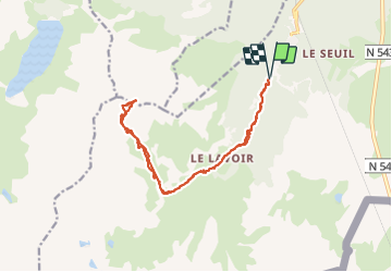
![](/images/other/stat-length.png)
![Tocht Ski randonnée Modane - pointe des sarrasins - Photo](https://media.geolcdn.com/t/1900/400/11a876bf-96a7-4155-9789-408cc9cbafaf.jpg&format=pjpeg&maxdim=2)
pointe des sarrasins
nadd73
Gebruiker GUIDE
![Lengte](/images/other/stat-length.png)
![Max. hoogte](https://static1.geolcdn.com/siteimages/upload/files/1508320355ic_sort_altitude_max_24dp.png)
![Positief hoogteverschil](https://static1.geolcdn.com/siteimages/upload/files/1508320355ic_sort_den_pos_24dp.png)
![Km-Effort](/images/other/stat-length.png)
![Min. hoogte](https://static1.geolcdn.com/siteimages/upload/files/1508320355ic_sort_altitude_min_24dp.png)
![Negatief hoogteverschil](https://static1.geolcdn.com/siteimages/upload/files/1508320355ic_sort_den_neg_24dp.png)
![Boucle](https://static1.geolcdn.com/siteimages/upload/files/16400158638029165_repeat_loop_refresh_sync_direction_icon.png)
![Ski randonnée](https://static1.geolcdn.com/sitytour/trail-icons/503.png)
5h17
Moeilijkheid : Medium
![Scan deze QR-code om de tocht te openen in de SityTrail-applicatie](https://capi.geolives.com/qq0zvz2zws4bq2lad0pu/sitytour/trails/3151175/qr.png?size=200)
Gratisgps-wandelapplicatie
Over ons
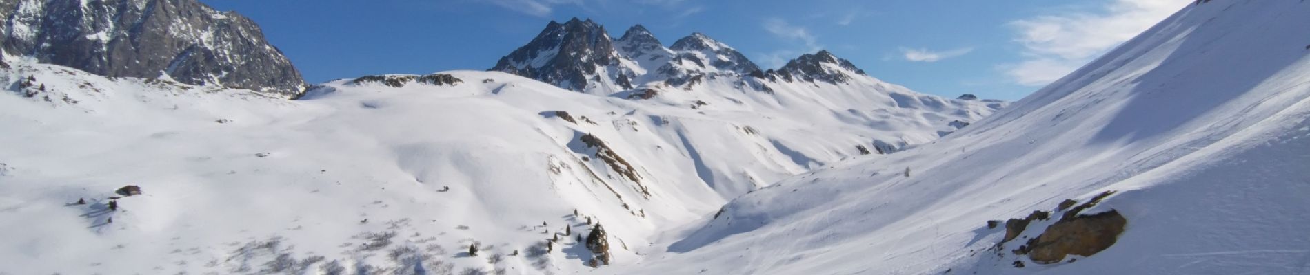
Tocht Ski randonnée van 17 km beschikbaar op Auvergne-Rhône-Alpes, Savoie, Modane. Deze tocht wordt voorgesteld door nadd73.
Beschrijving
Départ de Valfrejus, route du Lavoir au Plan monter derrière.
Assez long car pas mal de plat mais a partir du Plan le panorama est très beau. Je voulais descendre le couloir Sud mais étant seule et aucune personne en vue j'ai opté pour la sécurité.
Plaatsbepaling
Opmerkingen
Wandeltochten in de omgeving
![Tocht Stappen Modane - Valfrejus refuge du Mont Thabor - Photo](https://media.geolcdn.com/t/375/260/2ea31b81-693a-4382-810b-6d006cdc47b1.jpg&format=jpg&maxdim=2)
![Stappen Stappen](https://static1.geolcdn.com/sitytour/trail-icons/101.png)
Stappen
![](/images/other/stat-length.png)
![](https://static1.geolcdn.com/siteimages/upload/files/16400158638029165_repeat_loop_refresh_sync_direction_icon.png)
![Tocht Ski randonnée Modane - Le Grand Argentier - Photo](https://media.geolcdn.com/t/375/260/e21d4ca1-38c7-443d-8026-c36fbc8a0292.jpg&format=jpg&maxdim=2)
![Ski randonnée Ski randonnée](https://static1.geolcdn.com/sitytour/trail-icons/503.png)
Ski randonnée
![](/images/other/stat-length.png)
![](https://static1.geolcdn.com/siteimages/upload/files/16400158638029165_repeat_loop_refresh_sync_direction_icon.png)
![Tocht Ski randonnée Villarodin-Bourget - passage de la belle Plinier Nord - Photo](https://media.geolcdn.com/t/375/260/24fce6f9-d37e-4224-8f2c-4b95f0071df0.jpg&format=jpg&maxdim=2)
![Ski randonnée Ski randonnée](https://static1.geolcdn.com/sitytour/trail-icons/503.png)
Ski randonnée
![](/images/other/stat-length.png)
![](https://static1.geolcdn.com/siteimages/upload/files/16400158638029165_repeat_loop_refresh_sync_direction_icon.png)
![Tocht Ski randonnée Saint-André - Tête noire en boucle - Photo](https://media.geolcdn.com/t/375/260/0bb3542f-e5da-45e0-a1b0-86c9b0c52fb3.jpg&format=jpg&maxdim=2)
![Ski randonnée Ski randonnée](https://static1.geolcdn.com/sitytour/trail-icons/503.png)
Ski randonnée
![](/images/other/stat-length.png)
![](https://static1.geolcdn.com/siteimages/upload/files/16400158638029165_repeat_loop_refresh_sync_direction_icon.png)
![Tocht Sneeuwschoenen Saint-André - l Orgere - Photo](https://media.geolcdn.com/t/375/260/68f383ec-1a93-4bdd-ac56-2814b85cf93a.jpg&format=jpg&maxdim=2)
![Sneeuwschoenen Sneeuwschoenen](https://static1.geolcdn.com/sitytour/trail-icons/504.png)
Sneeuwschoenen
![](/images/other/stat-length.png)
![](https://static1.geolcdn.com/siteimages/upload/files/16400158638029165_repeat_loop_refresh_sync_direction_icon.png)
![Tocht Stappen Modane - mont Thabor - Photo](https://media.geolcdn.com/t/375/260/ext.jpg?maxdim=2&url=https%3A%2F%2Fstatic1.geolcdn.com%2Fsiteimages%2Fupload%2Ffiles%2F1553511878bg_sport_marche.png)
![Stappen Stappen](https://static1.geolcdn.com/sitytour/trail-icons/101.png)
Stappen
![](/images/other/stat-length.png)
![](https://static1.geolcdn.com/siteimages/upload/files/16400158638029165_repeat_loop_refresh_sync_direction_icon.png)
![Tocht Stappen Villarodin-Bourget - La Norma / Télécabine Melezet / Valfréjus - Photo](https://media.geolcdn.com/t/375/260/588a4be4-ac90-41f5-b3fb-9c859be949e5.jpg&format=jpg&maxdim=2)
![Stappen Stappen](https://static1.geolcdn.com/sitytour/trail-icons/101.png)
Stappen
![](/images/other/stat-length.png)
![](https://static1.geolcdn.com/siteimages/upload/files/16400158638029165_repeat_loop_refresh_sync_direction_icon.png)
![Tocht Stappen Modane - Télécabine Arrondaz Punta Bagna Lavoir Valfréjus - Photo](https://media.geolcdn.com/t/375/260/357497bc-6554-4d63-bbed-5431d02fde83.jpg&format=jpg&maxdim=2)
![Stappen Stappen](https://static1.geolcdn.com/sitytour/trail-icons/101.png)
Stappen
![](/images/other/stat-length.png)
![](https://static1.geolcdn.com/siteimages/upload/files/16400158638029165_repeat_loop_refresh_sync_direction_icon.png)
![Tocht Stappen Modane - Valfréjus Granges Areplane Les Herbiers Boucle - Photo](https://media.geolcdn.com/t/375/260/e6b14aab-5384-41f2-9c81-f18eecf735a8.jpg&format=jpg&maxdim=2)
![Stappen Stappen](https://static1.geolcdn.com/sitytour/trail-icons/101.png)
Stappen
![](/images/other/stat-length.png)
![](https://static1.geolcdn.com/siteimages/upload/files/16400158638029165_repeat_loop_refresh_sync_direction_icon.png)