![](/images/other/stat-length.png)
![Tocht Stappen Walhain - WALHAIN-SAINT-PAUL _ Marche Adeps _ BW _ 27/02/2022 - Photo](https://media.geolcdn.com/t/1900/400/ext.pjpeg?maxdim=2&url=https%3A%2F%2Fstatic1.geolcdn.com%2Fsiteimages%2Fupload%2Ffiles%2F1553511878bg_sport_marche.png)
WALHAIN-SAINT-PAUL _ Marche Adeps _ BW _ 27/02/2022
jeangulu
Gebruiker
![Lengte](/images/other/stat-length.png)
Lengte
20 km
![Max. hoogte](https://static1.geolcdn.com/siteimages/upload/files/1508320355ic_sort_altitude_max_24dp.png)
Max. hoogte
165 m
![Positief hoogteverschil](https://static1.geolcdn.com/siteimages/upload/files/1508320355ic_sort_den_pos_24dp.png)
Positief hoogteverschil
139 m
![Km-Effort](/images/other/stat-length.png)
Km-Effort
22 km
![Min. hoogte](https://static1.geolcdn.com/siteimages/upload/files/1508320355ic_sort_altitude_min_24dp.png)
Min. hoogte
142 m
![Negatief hoogteverschil](https://static1.geolcdn.com/siteimages/upload/files/1508320355ic_sort_den_neg_24dp.png)
Negatief hoogteverschil
140 m
![Boucle](https://static1.geolcdn.com/siteimages/upload/files/16400158638029165_repeat_loop_refresh_sync_direction_icon.png)
Boucle
Ja
Datum van aanmaak :
2022-02-27 09:03:37.339
Laatste wijziging :
2022-02-27 13:39:41.363
![Stappen](https://static1.geolcdn.com/sitytour/trail-icons/101.png)
4h35
Moeilijkheid : Gemakkelijk
![Scan deze QR-code om de tocht te openen in de SityTrail-applicatie](https://capi.geolives.com/qq0zvz2zws4bq2lad0pu/sitytour/trails/3148193/qr.png?size=200)
Gratisgps-wandelapplicatie
Over ons
Tocht Stappen van 20 km beschikbaar op Wallonië, Waals-Brabant, Walhain. Deze tocht wordt voorgesteld door jeangulu.
Beschrijving
Point de départ : Buvette du football- Rue Chapelle Saint-Anne [ 1457 ]
Entité _ Walhain
Carte IGN 40/6
Organisateur _ Comité Télévie _ Camille Verbaenen
Plaatsbepaling
Land:
Belgium
Regio :
Wallonië
Departement/Provincie :
Waals-Brabant
Gemeente :
Walhain
Locatie:
Unknown
Vertrek:(Dec)
Vertrek:(UTM)
620203 ; 5608640 (31U) N.
Opmerkingen
Wandeltochten in de omgeving
![Stappen Stappen](https://static1.geolcdn.com/sitytour/trail-icons/101.png)
#240223a - Blanmont, Orne, Alvaux, Nil Pierreux***
Stappen
Medium
(1)
Chastre,
Wallonië,
Waals-Brabant,
Belgium
![](/images/other/stat-length.png)
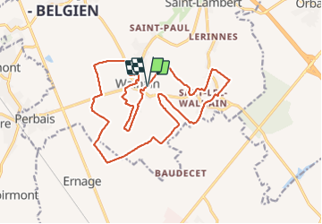
6,6 km | 7,8 km-effort
1h 47min
![](https://static1.geolcdn.com/siteimages/upload/files/16400158638029165_repeat_loop_refresh_sync_direction_icon.png)
Ja
![Tocht Stappen Chaumont-Gistoux - #231016 - Corroy-Le-Grand et le Val d'Ocquière*** (inversé court) - Photo](https://media.geolcdn.com/t/375/260/b650de28-d96e-49f2-85c2-d640aecfc352.jpg&format=jpg&maxdim=2)
![Stappen Stappen](https://static1.geolcdn.com/sitytour/trail-icons/101.png)
#231016 - Corroy-Le-Grand et le Val d'Ocquière*** (inversé court)
Stappen
Medium
(2)
Chaumont-Gistoux,
Wallonië,
Waals-Brabant,
Belgium
![](/images/other/stat-length.png)
6,2 km | 7,2 km-effort
1h 38min
![](https://static1.geolcdn.com/siteimages/upload/files/16400158638029165_repeat_loop_refresh_sync_direction_icon.png)
Ja
![Te voet Te voet](https://static1.geolcdn.com/sitytour/trail-icons/100.png)
#170829 - Nil Pierreux, carrières de quartzite, Moulin d'Al Poudre et Tour de...
Te voet
Heel gemakkelijk
(2)
Walhain,
Wallonië,
Waals-Brabant,
Belgium
![](/images/other/stat-length.png)
8,1 km | 9,9 km-effort
2h 0min
![](https://static1.geolcdn.com/siteimages/upload/files/16400158638029165_repeat_loop_refresh_sync_direction_icon.png)
Ja
![Tocht Stappen Chastre - Promenade de Villeroux - Photo](https://media.geolcdn.com/t/375/260/ext.jpg?maxdim=2&url=https%3A%2F%2Fservices.sitytrail.com%2FGeolivesWS%2FDownloadMedia.ashx%3FTrailID%3D233658%26Media%3D6ce217ee-b2e1-442a-b4a3-34a4ee262c13.JPG)
![Stappen Stappen](https://static1.geolcdn.com/sitytour/trail-icons/101.png)
Promenade de Villeroux
Stappen
Medium
(1)
Chastre,
Wallonië,
Waals-Brabant,
Belgium
![](/images/other/stat-length.png)
7,6 km | 8,5 km-effort
1h 53min
![](https://static1.geolcdn.com/siteimages/upload/files/16400158638029165_repeat_loop_refresh_sync_direction_icon.png)
Ja
![Tocht Stappen Chastre - Balade récréative de Cortil - Photo](https://media.geolcdn.com/t/375/260/ext.jpg?maxdim=2&url=https%3A%2F%2Fservices.sitytrail.com%2FGeolivesWS%2FDownloadMedia.ashx%3FTrailID%3D232278%26Media%3D010369e0-b48e-4ca2-9215-837380cbac27.jpg)
![Stappen Stappen](https://static1.geolcdn.com/sitytour/trail-icons/101.png)
Balade récréative de Cortil
Stappen
Gemakkelijk
(4)
Chastre,
Wallonië,
Waals-Brabant,
Belgium
![](/images/other/stat-length.png)
5,9 km | 6,5 km-effort
1h 26min
![](https://static1.geolcdn.com/siteimages/upload/files/16400158638029165_repeat_loop_refresh_sync_direction_icon.png)
Ja
![Tocht Stappen Chastre - Saint Gery - Namur - par le GR126 - Photo](https://media.geolcdn.com/t/375/260/18f2aab5-a522-40c8-9ccf-e3f0f1d2197a.jpg&format=jpg&maxdim=2)
![Stappen Stappen](https://static1.geolcdn.com/sitytour/trail-icons/101.png)
Saint Gery - Namur - par le GR126
Stappen
Zeer moeilijk
Chastre,
Wallonië,
Waals-Brabant,
Belgium
![](/images/other/stat-length.png)
38 km | 45 km-effort
10h 7min
![](https://static1.geolcdn.com/siteimages/upload/files/16400158638029165_repeat_loop_refresh_sync_direction_icon.png)
Neen
![Tocht Stappen Gembloers - bgg - ernage bertinchamps gentines chastre perbais - Photo](https://media.geolcdn.com/t/375/260/acd4923b-00bd-46a5-bc73-b141f9ba9715.jpg&format=jpg&maxdim=2)
![Stappen Stappen](https://static1.geolcdn.com/sitytour/trail-icons/101.png)
bgg - ernage bertinchamps gentines chastre perbais
Stappen
Moeilijk
Gembloers,
Wallonië,
Namen,
Belgium
![](/images/other/stat-length.png)
22 km | 24 km-effort
4h 36min
![](https://static1.geolcdn.com/siteimages/upload/files/16400158638029165_repeat_loop_refresh_sync_direction_icon.png)
Ja
![Tocht Stappen Chastre - gb - chastre grand tour fractionnable - Photo](https://media.geolcdn.com/t/375/260/445a307c-701a-4e90-a82a-45f885f3b381.jpg&format=jpg&maxdim=2)
![Stappen Stappen](https://static1.geolcdn.com/sitytour/trail-icons/101.png)
gb - chastre grand tour fractionnable
Stappen
Zeer moeilijk
Chastre,
Wallonië,
Waals-Brabant,
Belgium
![](/images/other/stat-length.png)
28 km | 32 km-effort
5h 49min
![](https://static1.geolcdn.com/siteimages/upload/files/16400158638029165_repeat_loop_refresh_sync_direction_icon.png)
Ja
![Tocht Stappen Gembloers - covid 17-4-20 12 km - Photo](https://media.geolcdn.com/t/375/260/575ef2e1-64c3-47f4-a366-815bffa60540.jpg&format=jpg&maxdim=2)
![Stappen Stappen](https://static1.geolcdn.com/sitytour/trail-icons/101.png)
covid 17-4-20 12 km
Stappen
Heel gemakkelijk
(1)
Gembloers,
Wallonië,
Namen,
Belgium
![](/images/other/stat-length.png)
12,8 km | 14,2 km-effort
2h 18min
![](https://static1.geolcdn.com/siteimages/upload/files/16400158638029165_repeat_loop_refresh_sync_direction_icon.png)
Ja