![](/images/other/stat-length.png)
![Tocht Stappen La Plaine-sur-Mer - La pointe de la Pierre - Photo](https://media.geolcdn.com/t/1900/400/ext.pjpeg?maxdim=2&url=https%3A%2F%2Fstatic1.geolcdn.com%2Fsiteimages%2Fupload%2Ffiles%2F1553511878bg_sport_marche.png)
La pointe de la Pierre
neoroll44
Gebruiker
![Lengte](/images/other/stat-length.png)
Lengte
9,4 km
![Max. hoogte](https://static1.geolcdn.com/siteimages/upload/files/1508320355ic_sort_altitude_max_24dp.png)
Max. hoogte
25 m
![Positief hoogteverschil](https://static1.geolcdn.com/siteimages/upload/files/1508320355ic_sort_den_pos_24dp.png)
Positief hoogteverschil
60 m
![Km-Effort](/images/other/stat-length.png)
Km-Effort
10,2 km
![Min. hoogte](https://static1.geolcdn.com/siteimages/upload/files/1508320355ic_sort_altitude_min_24dp.png)
Min. hoogte
1 m
![Negatief hoogteverschil](https://static1.geolcdn.com/siteimages/upload/files/1508320355ic_sort_den_neg_24dp.png)
Negatief hoogteverschil
60 m
![Boucle](https://static1.geolcdn.com/siteimages/upload/files/16400158638029165_repeat_loop_refresh_sync_direction_icon.png)
Boucle
Ja
Datum van aanmaak :
2022-02-27 08:59:36.447
Laatste wijziging :
2022-02-27 09:01:50.851
![Stappen](https://static1.geolcdn.com/sitytour/trail-icons/101.png)
2h30
Moeilijkheid : Medium
![Scan deze QR-code om de tocht te openen in de SityTrail-applicatie](https://capi.geolives.com/qq0zvz2zws4bq2lad0pu/sitytour/trails/3147694/qr.png?size=200)
Gratisgps-wandelapplicatie
Over ons
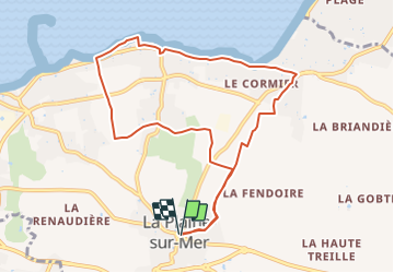
Tocht Stappen van 9,4 km beschikbaar op Pays de la Loire, Loire-Atlantique, La Plaine-sur-Mer. Deze tocht wordt voorgesteld door neoroll44.
Beschrijving
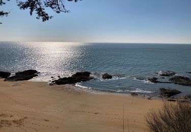
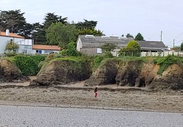
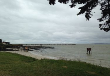
Depuis l'église de la Plaine sur Mer, vers le Cormier, longer la mer, passer la pointe de la Pierre et retour par la campagne.
Plaatsbepaling
Land:
France
Regio :
Pays de la Loire
Departement/Provincie :
Loire-Atlantique
Gemeente :
La Plaine-sur-Mer
Locatie:
Unknown
Vertrek:(Dec)
Vertrek:(UTM)
561322 ; 5220791 (30T) N.
Opmerkingen
Wandeltochten in de omgeving
![Tocht Stappen Saint-Michel-Chef-Chef - St Michel chef chef st Brevin les pins - Photo](https://media.geolcdn.com/t/375/260/c61c664a-852e-412f-9c74-0d8191a78cd6.jpg&format=jpg&maxdim=2)
![Stappen Stappen](https://static1.geolcdn.com/sitytour/trail-icons/101.png)
St Michel chef chef st Brevin les pins
Stappen
Medium
Saint-Michel-Chef-Chef,
Pays de la Loire,
Loire-Atlantique,
France
![](/images/other/stat-length.png)
7 km | 7,8 km-effort
1h 52min
![](https://static1.geolcdn.com/siteimages/upload/files/16400158638029165_repeat_loop_refresh_sync_direction_icon.png)
Ja
![Tocht Stappen Préfailles - Boucle en pointe de Saint Gildas - Photo](https://media.geolcdn.com/t/375/260/38fd5f4a-0ffa-466a-8e18-2f488e284f1b.jpg&format=jpg&maxdim=2)
![Stappen Stappen](https://static1.geolcdn.com/sitytour/trail-icons/101.png)
Boucle en pointe de Saint Gildas
Stappen
Heel gemakkelijk
Préfailles,
Pays de la Loire,
Loire-Atlantique,
France
![](/images/other/stat-length.png)
16 km | 17,3 km-effort
4h 10min
![](https://static1.geolcdn.com/siteimages/upload/files/16400158638029165_repeat_loop_refresh_sync_direction_icon.png)
Ja
![Tocht Te voet Préfailles - Pointe Saint-Gildas - Photo](https://media.geolcdn.com/t/375/260/d0c5c2f6-34d6-4bc5-b58c-e9e0785cf5f0.jpeg&format=jpg&maxdim=2)
![Te voet Te voet](https://static1.geolcdn.com/sitytour/trail-icons/100.png)
Pointe Saint-Gildas
Te voet
Gemakkelijk
Préfailles,
Pays de la Loire,
Loire-Atlantique,
France
![](/images/other/stat-length.png)
7,3 km | 8 km-effort
1h 49min
![](https://static1.geolcdn.com/siteimages/upload/files/16400158638029165_repeat_loop_refresh_sync_direction_icon.png)
Ja
![Tocht Stappen La Plaine-sur-Mer - La plaine sur Mer - Pornic - Photo](https://media.geolcdn.com/t/375/260/3e6d4e01-0318-4670-946f-5a06ee1210d0.jpg&format=jpg&maxdim=2)
![Stappen Stappen](https://static1.geolcdn.com/sitytour/trail-icons/101.png)
La plaine sur Mer - Pornic
Stappen
Medium
La Plaine-sur-Mer,
Pays de la Loire,
Loire-Atlantique,
France
![](/images/other/stat-length.png)
20 km | 22 km-effort
3h 59min
![](https://static1.geolcdn.com/siteimages/upload/files/16400158638029165_repeat_loop_refresh_sync_direction_icon.png)
Neen
![Tocht Stappen Préfailles - Pointe de St Gildas - Photo](https://media.geolcdn.com/t/375/260/676edf4a-b6e7-4a74-8e49-d68639926018.jpg&format=jpg&maxdim=2)
![Stappen Stappen](https://static1.geolcdn.com/sitytour/trail-icons/101.png)
Pointe de St Gildas
Stappen
Heel gemakkelijk
Préfailles,
Pays de la Loire,
Loire-Atlantique,
France
![](/images/other/stat-length.png)
9,5 km | 10,5 km-effort
3h 7min
![](https://static1.geolcdn.com/siteimages/upload/files/16400158638029165_repeat_loop_refresh_sync_direction_icon.png)
Ja
![Tocht Stappen La Plaine-sur-Mer - pornichet - Photo](https://media.geolcdn.com/t/375/260/a6e703b2-84bf-42ae-ac9b-cf1d1769c179.jpg&format=jpg&maxdim=2)
![Stappen Stappen](https://static1.geolcdn.com/sitytour/trail-icons/101.png)
pornichet
Stappen
Heel gemakkelijk
La Plaine-sur-Mer,
Pays de la Loire,
Loire-Atlantique,
France
![](/images/other/stat-length.png)
58 km | 63 km-effort
4h 26min
![](https://static1.geolcdn.com/siteimages/upload/files/16400158638029165_repeat_loop_refresh_sync_direction_icon.png)
Neen
![Tocht Andere activiteiten La Plaine-sur-Mer - côte des moutons - Photo](https://media.geolcdn.com/t/375/260/ext.jpg?maxdim=2&url=https%3A%2F%2Fservices.sitytrail.com%2FGeolivesWS%2FDownloadMedia.ashx%3FTrailID%3D558942%26Media%3D20160425170255.jpg)
![Andere activiteiten Andere activiteiten](https://static1.geolcdn.com/sitytour/trail-icons/900.png)
côte des moutons
Andere activiteiten
Gemakkelijk
La Plaine-sur-Mer,
Pays de la Loire,
Loire-Atlantique,
France
![](/images/other/stat-length.png)
13 km | 14 km-effort
3h 32min
![](https://static1.geolcdn.com/siteimages/upload/files/16400158638029165_repeat_loop_refresh_sync_direction_icon.png)
Ja
![Tocht Mountainbike La Plaine-sur-Mer - La Plaine Eric 3 - Photo](https://media.geolcdn.com/t/375/260/ext.jpg?maxdim=2&url=https%3A%2F%2Fstatic1.geolcdn.com%2Fsiteimages%2Fupload%2Ffiles%2F1524743154velo.jpg)
![Mountainbike Mountainbike](https://static1.geolcdn.com/sitytour/trail-icons/202.png)
La Plaine Eric 3
Mountainbike
Medium
La Plaine-sur-Mer,
Pays de la Loire,
Loire-Atlantique,
France
![](/images/other/stat-length.png)
31 km | 35 km-effort
2h 7min
![](https://static1.geolcdn.com/siteimages/upload/files/16400158638029165_repeat_loop_refresh_sync_direction_icon.png)
Ja
![Tocht Stappen Saint-Michel-Chef-Chef - 2023-06-03 st Michel chef chef circuit littoral et moulins - Photo](https://media.geolcdn.com/t/375/260/b5dec514-b985-4f83-b732-11df6eab5f8a.jpg&format=jpg&maxdim=2)
![Stappen Stappen](https://static1.geolcdn.com/sitytour/trail-icons/101.png)
2023-06-03 st Michel chef chef circuit littoral et moulins
Stappen
Moeilijk
Saint-Michel-Chef-Chef,
Pays de la Loire,
Loire-Atlantique,
France
![](/images/other/stat-length.png)
15,7 km | 17,2 km-effort
3h 20min
![](https://static1.geolcdn.com/siteimages/upload/files/16400158638029165_repeat_loop_refresh_sync_direction_icon.png)
Neen