![](/images/other/stat-length.png)
![Tocht Stappen Artigue - 2022-02-26 Artigue - cabane de peyrehitte - mont Majou - luchonais - Photo](https://media.geolcdn.com/t/1900/400/d3d7c3f2-a654-4693-9bbc-04b518c9f33d.jpg&format=pjpeg&maxdim=2)
2022-02-26 Artigue - cabane de peyrehitte - mont Majou - luchonais
jacq58
Gebruiker
![Lengte](/images/other/stat-length.png)
Lengte
12 km
![Max. hoogte](https://static1.geolcdn.com/siteimages/upload/files/1508320355ic_sort_altitude_max_24dp.png)
Max. hoogte
1943 m
![Positief hoogteverschil](https://static1.geolcdn.com/siteimages/upload/files/1508320355ic_sort_den_pos_24dp.png)
Positief hoogteverschil
730 m
![Km-Effort](/images/other/stat-length.png)
Km-Effort
22 km
![Min. hoogte](https://static1.geolcdn.com/siteimages/upload/files/1508320355ic_sort_altitude_min_24dp.png)
Min. hoogte
1214 m
![Negatief hoogteverschil](https://static1.geolcdn.com/siteimages/upload/files/1508320355ic_sort_den_neg_24dp.png)
Negatief hoogteverschil
733 m
![Boucle](https://static1.geolcdn.com/siteimages/upload/files/16400158638029165_repeat_loop_refresh_sync_direction_icon.png)
Boucle
Ja
Datum van aanmaak :
2022-02-26 09:09:28.222
Laatste wijziging :
2022-02-28 19:39:04.962
![Stappen](https://static1.geolcdn.com/sitytour/trail-icons/101.png)
3h33
Moeilijkheid : Moeilijk
![Scan deze QR-code om de tocht te openen in de SityTrail-applicatie](https://capi.geolives.com/qq0zvz2zws4bq2lad0pu/sitytour/trails/3147019/qr.png?size=200)
Gratisgps-wandelapplicatie
Over ons
Tocht Stappen van 12 km beschikbaar op Occitanië, Haute-Garonne, Artigue. Deze tocht wordt voorgesteld door jacq58.
Beschrijving
départ du parking juste à l'entrée de Artigue, aller jusqu'à l'église et prendre le chemin qui monte légèrement à droite et suivre le balisage blanc et rouge du GR10.
Plaatsbepaling
Land:
France
Regio :
Occitanië
Departement/Provincie :
Haute-Garonne
Gemeente :
Artigue
Locatie:
Unknown
Vertrek:(Dec)
Vertrek:(UTM)
305409 ; 4744678 (31T) N.
Opmerkingen
Wandeltochten in de omgeving
![Tocht Sneeuwschoenen Juzet-de-Luchon - JUZET - PAS DE LA COMBE (LABACH) - Photo](https://media.geolcdn.com/t/375/260/ext.jpg?maxdim=2&url=https%3A%2F%2Fservices.sitytrail.com%2FGeolivesWS%2FDownloadMedia.ashx%3FTrailID%3D689507%26Media%3Dfix__20170125152906.jpg)
![Sneeuwschoenen Sneeuwschoenen](https://static1.geolcdn.com/sitytour/trail-icons/504.png)
JUZET - PAS DE LA COMBE (LABACH)
Sneeuwschoenen
Medium
(1)
Juzet-de-Luchon,
Occitanië,
Haute-Garonne,
France
![](/images/other/stat-length.png)
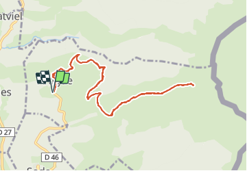
7,1 km | 12,5 km-effort
2h 33min
![](https://static1.geolcdn.com/siteimages/upload/files/16400158638029165_repeat_loop_refresh_sync_direction_icon.png)
Ja
![Tocht Stappen Saccourvielle - Cap de Salières en boucle depuis Saccourvielle - Photo](https://media.geolcdn.com/t/375/260/9067fbef-09d4-4f17-8717-9e32e9492c01.jpg&format=jpg&maxdim=2)
![Stappen Stappen](https://static1.geolcdn.com/sitytour/trail-icons/101.png)
Cap de Salières en boucle depuis Saccourvielle
Stappen
Medium
Saccourvielle,
Occitanië,
Haute-Garonne,
France
![](/images/other/stat-length.png)
12,1 km | 24 km-effort
6h 23min
![](https://static1.geolcdn.com/siteimages/upload/files/16400158638029165_repeat_loop_refresh_sync_direction_icon.png)
Ja
![Tocht Stappen Baren - mail de la Pique 01 2018 - Photo](https://media.geolcdn.com/t/375/260/ext.jpg?maxdim=2&url=https%3A%2F%2Fservices.sitytrail.com%2FGeolivesWS%2FDownloadMedia.ashx%3FTrailID%3D893844%26Media%3Dfix__20180118101934.jpg)
![Stappen Stappen](https://static1.geolcdn.com/sitytour/trail-icons/101.png)
mail de la Pique 01 2018
Stappen
Heel gemakkelijk
(1)
Baren,
Occitanië,
Haute-Garonne,
France
![](/images/other/stat-length.png)
7,6 km | 19,1 km-effort
4h 55min
![](https://static1.geolcdn.com/siteimages/upload/files/16400158638029165_repeat_loop_refresh_sync_direction_icon.png)
Ja
![Tocht Stappen Bagnères-de-Luchon - GR 10 - 3 - Photo](https://media.geolcdn.com/t/375/260/ext.jpg?maxdim=2&url=https%3A%2F%2Fstatic1.geolcdn.com%2Fsiteimages%2Fupload%2Ffiles%2F1553511878bg_sport_marche.png)
![Stappen Stappen](https://static1.geolcdn.com/sitytour/trail-icons/101.png)
GR 10 - 3
Stappen
Medium
(2)
Bagnères-de-Luchon,
Occitanië,
Haute-Garonne,
France
![](/images/other/stat-length.png)
250 km | 489 km-effort
89h 8min
![](https://static1.geolcdn.com/siteimages/upload/files/16400158638029165_repeat_loop_refresh_sync_direction_icon.png)
Neen
![Tocht Stappen Artigue - ARTIGUE - Gouaux de Luchon - chemin forestier - Photo](https://media.geolcdn.com/t/375/260/ext.jpg?maxdim=2&url=https%3A%2F%2Fstatic1.geolcdn.com%2Fsiteimages%2Fupload%2Ffiles%2F1553511878bg_sport_marche.png)
![Stappen Stappen](https://static1.geolcdn.com/sitytour/trail-icons/101.png)
ARTIGUE - Gouaux de Luchon - chemin forestier
Stappen
Medium
(1)
Artigue,
Occitanië,
Haute-Garonne,
France
![](/images/other/stat-length.png)
13,7 km | 23 km-effort
3h 21min
![](https://static1.geolcdn.com/siteimages/upload/files/16400158638029165_repeat_loop_refresh_sync_direction_icon.png)
Ja
![Tocht Stappen Artigue - Artigue pic de Bacanere - Photo](https://media.geolcdn.com/t/375/260/0674b2f2-ba98-48ee-8365-d627d97b03e5.jpg&format=jpg&maxdim=2)
![Stappen Stappen](https://static1.geolcdn.com/sitytour/trail-icons/101.png)
Artigue pic de Bacanere
Stappen
Zeer moeilijk
Artigue,
Occitanië,
Haute-Garonne,
France
![](/images/other/stat-length.png)
15,1 km | 29 km-effort
6h 31min
![](https://static1.geolcdn.com/siteimages/upload/files/16400158638029165_repeat_loop_refresh_sync_direction_icon.png)
Ja
![Tocht Stappen Sode - cabane de Plan Pouné, par refuge de Cualot - Photo](https://media.geolcdn.com/t/375/260/36e8fbb1-a132-4062-9b5e-14952719d757.jpg&format=jpg&maxdim=2)
![Stappen Stappen](https://static1.geolcdn.com/sitytour/trail-icons/101.png)
cabane de Plan Pouné, par refuge de Cualot
Stappen
Zeer moeilijk
Sode,
Occitanië,
Haute-Garonne,
France
![](/images/other/stat-length.png)
9,8 km | 19,5 km-effort
4h 26min
![](https://static1.geolcdn.com/siteimages/upload/files/16400158638029165_repeat_loop_refresh_sync_direction_icon.png)
Ja
![Tocht Stappen Artigue - Artigue par la cabane du plan Bosc et la cabane de Saunères - Photo](https://media.geolcdn.com/t/375/260/3c7be430-12b7-4318-be61-25352c65f0e4.jpg&format=jpg&maxdim=2)
![Stappen Stappen](https://static1.geolcdn.com/sitytour/trail-icons/101.png)
Artigue par la cabane du plan Bosc et la cabane de Saunères
Stappen
Moeilijk
Artigue,
Occitanië,
Haute-Garonne,
France
![](/images/other/stat-length.png)
10,5 km | 18,3 km-effort
4h 10min
![](https://static1.geolcdn.com/siteimages/upload/files/16400158638029165_repeat_loop_refresh_sync_direction_icon.png)
Ja
![Tocht Stappen Baren - Mail de la Pique depuis Baren - Photo](https://media.geolcdn.com/t/375/260/574d7441-59c2-4f23-a4a5-6c5993228bb5.jpg&format=jpg&maxdim=2)
![Stappen Stappen](https://static1.geolcdn.com/sitytour/trail-icons/101.png)
Mail de la Pique depuis Baren
Stappen
Moeilijk
Baren,
Occitanië,
Haute-Garonne,
France
![](/images/other/stat-length.png)
9,8 km | 23 km-effort
6h 43min
![](https://static1.geolcdn.com/siteimages/upload/files/16400158638029165_repeat_loop_refresh_sync_direction_icon.png)
Ja