Tocht Te voet Unknown - 
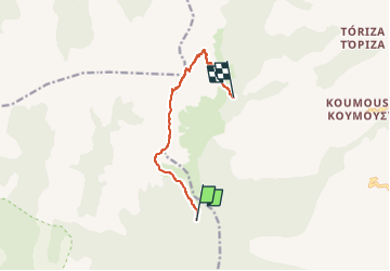
Pathway to Taygetos Peak - Photo

Tous les sentiers balisés d’Europe GUIDE+

© OpenStreetMap contributors
Lengte
Lengte
8,6 km
Max. hoogte
Max. hoogte
2381 m
Positief hoogteverschil
865 m
Km-Effort
Km-Effort  
19,9 km
Min. hoogte
Min. hoogte
1512 m
Negatief hoogteverschil
811 m
Boucle
Boucle
Neen
Markering
Markering
Datum van aanmaak :
2022-02-21 10:56:20.862
Laatste wijziging :
2022-03-09 00:56:49.967

(0 Bericht)

Te voet
Te voet
4h31
Moeilijkheid : Gemakkelijk

Scan deze QR-code om de tocht te openen in de SityTrail-applicatie

Gratisgps-wandelapplicatie

Logo SityTrail SityTrail

IGN / Geografische instituten

SityTrail uit de App Store downloaden SityTrail uit Google Play downloaden

Logo SityTrail SityTrail World

De wereld gaat voor u open

SityTrail uit de App Store downloaden SityTrail uit Google Play downloaden SityTrail op Huawei AppGallery downloaden

Over ons

Tocht Te voet van 8,6 km beschikbaar op Peloponnesos, West-Griekenland en Ionische Eilanden, Messenië. Deze tocht wordt voorgesteld door SityTrail - itinéraires balisés pédestres.

Beschrijving

Trail created by Alpine Club of Kalamata.

Symbol: red square on white ground

Hoogteprofiel

Foto's

Plaatsbepaling

Land:
Greece
Regio :
Peloponnesos, West-Griekenland en Ionische Eilanden
Departement/Provincie :
Messenië
Gemeente :
Unknown
Locatie:
Unknown
Vertrek:(UTM)
620717 ; 4086765 (34S) N.

Wandeltochten in de omgeving


Sluiten
Mijn abonnementen