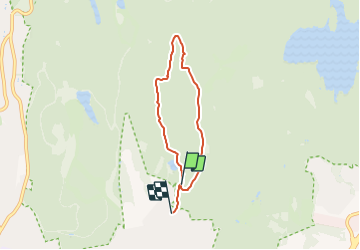
![](/images/other/stat-length.png)
![Tocht Te voet Onbekend - Årvollåsen natursti - Photo](https://media.geolcdn.com/t/1900/400/23ffdc41-0e10-4471-9c42-963601d8c82d.jpeg&format=pjpeg&maxdim=2)
Årvollåsen natursti
SityTrail - itinéraires balisés pédestres
Tous les sentiers balisés d’Europe GUIDE+
![Lengte](/images/other/stat-length.png)
Lengte
3,7 km
![Max. hoogte](https://static1.geolcdn.com/siteimages/upload/files/1508320355ic_sort_altitude_max_24dp.png)
Max. hoogte
364 m
![Positief hoogteverschil](https://static1.geolcdn.com/siteimages/upload/files/1508320355ic_sort_den_pos_24dp.png)
Positief hoogteverschil
142 m
![Km-Effort](/images/other/stat-length.png)
Km-Effort
5,8 km
![Min. hoogte](https://static1.geolcdn.com/siteimages/upload/files/1508320355ic_sort_altitude_min_24dp.png)
Min. hoogte
201 m
![Negatief hoogteverschil](https://static1.geolcdn.com/siteimages/upload/files/1508320355ic_sort_den_neg_24dp.png)
Negatief hoogteverschil
183 m
![Boucle](https://static1.geolcdn.com/siteimages/upload/files/16400158638029165_repeat_loop_refresh_sync_direction_icon.png)
Boucle
Neen
Markering
Datum van aanmaak :
2022-02-21 10:17:52.275
Laatste wijziging :
2022-03-08 16:36:40.94
![Te voet](https://static1.geolcdn.com/sitytour/trail-icons/100.png)
1h18
Moeilijkheid : Gemakkelijk
![Scan deze QR-code om de tocht te openen in de SityTrail-applicatie](https://capi.geolives.com/qq0zvz2zws4bq2lad0pu/sitytour/trails/3137752/qr.png?size=200)
Gratisgps-wandelapplicatie
Over ons
Tocht Te voet van 3,7 km beschikbaar op Oslo, Onbekend, Onbekend. Deze tocht wordt voorgesteld door SityTrail - itinéraires balisés pédestres.
Beschrijving
Trail created by Oslo kommune Bymiljøetaten.
Symbol: White pine tree on dark green square
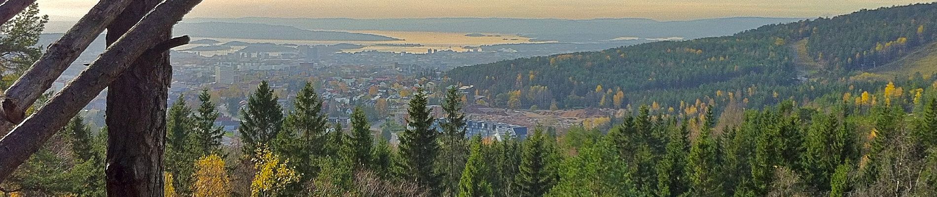
Plaatsbepaling
Land:
Norway
Regio :
Oslo
Departement/Provincie :
Onbekend
Gemeente :
Onbekend
Locatie:
Marka
Vertrek:(Dec)
Vertrek:(UTM)
601922 ; 6647721 (32V) N.
Opmerkingen
Wandeltochten in de omgeving
![Tocht Te voet Onbekend - Turvei D7 - Photo](https://media.geolcdn.com/t/375/260/cd2c1cd0-0592-49be-ad1e-8e1d3f28ab9a.jpeg&format=jpg&maxdim=2)
![Te voet Te voet](https://static1.geolcdn.com/sitytour/trail-icons/100.png)
![Tocht Te voet Onbekend - Turvei D13 - Photo](https://media.geolcdn.com/t/375/260/480c553f-8800-4296-af7c-f08105447ef1.jpeg&format=jpg&maxdim=2)
![Te voet Te voet](https://static1.geolcdn.com/sitytour/trail-icons/100.png)
![Tocht Te voet Onbekend - Turvei C2 - Photo](https://media.geolcdn.com/t/375/260/fce88b7f-ece8-4965-8838-a71117e9dce1.jpeg&format=jpg&maxdim=2)
![Te voet Te voet](https://static1.geolcdn.com/sitytour/trail-icons/100.png)
![Tocht Te voet Onbekend - Turvei B10 - Photo](https://media.geolcdn.com/t/375/260/fb496965-feed-44b1-8386-98fe10d2f26d.jpeg&format=jpg&maxdim=2)
![Te voet Te voet](https://static1.geolcdn.com/sitytour/trail-icons/100.png)
![Tocht Te voet Onbekend - Ammerud natursti - Photo](https://media.geolcdn.com/t/375/260/e8a223e0-3dee-4a36-863d-45a9786f9721.jpeg&format=jpg&maxdim=2)
![Te voet Te voet](https://static1.geolcdn.com/sitytour/trail-icons/100.png)
Ammerud natursti
Te voet
Gemakkelijk
Onbekend,
Oslo,
Onbekend,
Norway
![](/images/other/stat-length.png)
3,5 km | 4,5 km-effort
1h 1min
![](https://static1.geolcdn.com/siteimages/upload/files/16400158638029165_repeat_loop_refresh_sync_direction_icon.png)
Neen
![Tocht Te voet Onbekend - Turvei Linderudkollen - Photo](https://media.geolcdn.com/t/375/260/009c6b4b-4802-4624-ac04-26368776ce4f.jpeg&format=jpg&maxdim=2)
![Te voet Te voet](https://static1.geolcdn.com/sitytour/trail-icons/100.png)
Turvei Linderudkollen
Te voet
Gemakkelijk
Onbekend,
Oslo,
Onbekend,
Norway
![](/images/other/stat-length.png)
3,1 km | 3,6 km-effort
48min
![](https://static1.geolcdn.com/siteimages/upload/files/16400158638029165_repeat_loop_refresh_sync_direction_icon.png)
Neen
![Tocht Te voet Onbekend - Turvei D10 - Photo](https://media.geolcdn.com/t/375/260/35e15ddf-5f52-4db9-937b-9e039325684f.jpeg&format=jpg&maxdim=2)
![Te voet Te voet](https://static1.geolcdn.com/sitytour/trail-icons/100.png)
![Tocht Stappen Onbekend - balade d'une heure - Photo](https://media.geolcdn.com/t/375/260/da73175d-679a-4cf3-8812-a9694850ca08.jpg&format=jpg&maxdim=2)
![Stappen Stappen](https://static1.geolcdn.com/sitytour/trail-icons/101.png)
balade d'une heure
Stappen
Gemakkelijk
Onbekend,
Oslo,
Onbekend,
Norway
![](/images/other/stat-length.png)
3,2 km | 4,4 km-effort
1h 0min
![](https://static1.geolcdn.com/siteimages/upload/files/16400158638029165_repeat_loop_refresh_sync_direction_icon.png)
Ja
![Tocht Stappen Onbekend - Pslo3 - Photo](https://media.geolcdn.com/t/375/260/ext.jpg?maxdim=2&url=https%3A%2F%2Fstatic1.geolcdn.com%2Fsiteimages%2Fupload%2Ffiles%2F1553511878bg_sport_marche.png)
![Stappen Stappen](https://static1.geolcdn.com/sitytour/trail-icons/101.png)