![](/images/other/stat-length.png)
![Tocht Stappen Héricourt-en-Caux - La vallée de la Durdent , au départ d'Héricourt en Caux (34) - Photo](https://media.geolcdn.com/t/1900/400/ext.pjpeg?maxdim=2&url=https%3A%2F%2Fstatic1.geolcdn.com%2Fsiteimages%2Fupload%2Ffiles%2F1553511878bg_sport_marche.png)
La vallée de la Durdent , au départ d'Héricourt en Caux (34)
randovivi
Gebruiker
![Lengte](/images/other/stat-length.png)
Lengte
15,9 km
![Max. hoogte](https://static1.geolcdn.com/siteimages/upload/files/1508320355ic_sort_altitude_max_24dp.png)
Max. hoogte
137 m
![Positief hoogteverschil](https://static1.geolcdn.com/siteimages/upload/files/1508320355ic_sort_den_pos_24dp.png)
Positief hoogteverschil
284 m
![Km-Effort](/images/other/stat-length.png)
Km-Effort
19,7 km
![Min. hoogte](https://static1.geolcdn.com/siteimages/upload/files/1508320355ic_sort_altitude_min_24dp.png)
Min. hoogte
42 m
![Negatief hoogteverschil](https://static1.geolcdn.com/siteimages/upload/files/1508320355ic_sort_den_neg_24dp.png)
Negatief hoogteverschil
282 m
![Boucle](https://static1.geolcdn.com/siteimages/upload/files/16400158638029165_repeat_loop_refresh_sync_direction_icon.png)
Boucle
Ja
Datum van aanmaak :
2016-03-09 00:00:00.0
Laatste wijziging :
2016-03-09 00:00:00.0
![Stappen](https://static1.geolcdn.com/sitytour/trail-icons/101.png)
5h00
Moeilijkheid : Medium
![Scan deze QR-code om de tocht te openen in de SityTrail-applicatie](https://capi.geolives.com/qq0zvz2zws4bq2lad0pu/sitytour/trails/313706/qr.png?size=200)
Gratisgps-wandelapplicatie
Over ons
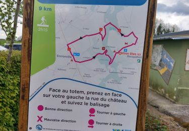
Tocht Stappen van 15,9 km beschikbaar op Normandië, Seine-Maritime, Héricourt-en-Caux. Deze tocht wordt voorgesteld door randovivi.
Beschrijving
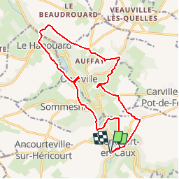
Héricourt en Caux - la Belle Hélène - Oherville - Le Hanouard - Auffay - le Bout Enragé - Carville pot de fer - le Petit Veauville
Plaatsbepaling
Land:
France
Regio :
Normandië
Departement/Provincie :
Seine-Maritime
Gemeente :
Héricourt-en-Caux
Locatie:
Unknown
Vertrek:(Dec)
Vertrek:(UTM)
333785 ; 5507352 (31U) N.
Opmerkingen
Wandeltochten in de omgeving
![Tocht Stappen Rocquefort - Rocquefort - Photo](https://media.geolcdn.com/t/375/260/092262e9-5821-4236-8cea-6e39175f63f4.jpg&format=jpg&maxdim=2)
![Stappen Stappen](https://static1.geolcdn.com/sitytour/trail-icons/101.png)
Rocquefort
Stappen
Moeilijk
Rocquefort,
Normandië,
Seine-Maritime,
France
![](/images/other/stat-length.png)
11,8 km | 14 km-effort
2h 47min
![](https://static1.geolcdn.com/siteimages/upload/files/16400158638029165_repeat_loop_refresh_sync_direction_icon.png)
Ja
![Tocht Stappen Rocquefort - rocquefort - Photo](https://media.geolcdn.com/t/375/260/2f186a64-fd1c-473f-90dc-2aefb8009227.jpg&format=jpg&maxdim=2)
![Stappen Stappen](https://static1.geolcdn.com/sitytour/trail-icons/101.png)
rocquefort
Stappen
Medium
Rocquefort,
Normandië,
Seine-Maritime,
France
![](/images/other/stat-length.png)
8 km | 9,3 km-effort
2h 31min
![](https://static1.geolcdn.com/siteimages/upload/files/16400158638029165_repeat_loop_refresh_sync_direction_icon.png)
Ja
![Tocht Stappen Héricourt-en-Caux - hericout hoherville - Photo](https://media.geolcdn.com/t/375/260/e370aab6-44e5-45a3-9207-74b237cbbebd.jpg&format=jpg&maxdim=2)
![Stappen Stappen](https://static1.geolcdn.com/sitytour/trail-icons/101.png)
hericout hoherville
Stappen
Medium
Héricourt-en-Caux,
Normandië,
Seine-Maritime,
France
![](/images/other/stat-length.png)
11,4 km | 14,1 km-effort
2h 38min
![](https://static1.geolcdn.com/siteimages/upload/files/16400158638029165_repeat_loop_refresh_sync_direction_icon.png)
Ja
![Tocht Te voet Rocquefort - 211c - Photo](https://media.geolcdn.com/t/375/260/75d4786a-c043-4388-8a3f-e6a629b9c0a0.jpeg&format=jpg&maxdim=2)
![Te voet Te voet](https://static1.geolcdn.com/sitytour/trail-icons/100.png)
211c
Te voet
Gemakkelijk
Rocquefort,
Normandië,
Seine-Maritime,
France
![](/images/other/stat-length.png)
12,9 km | 14,5 km-effort
3h 17min
![](https://static1.geolcdn.com/siteimages/upload/files/16400158638029165_repeat_loop_refresh_sync_direction_icon.png)
Neen
![Tocht Andere activiteiten Héricourt-en-Caux - Sur les pas de Jehan le Povremoyne - Héricourt-en-Caux - Photo](https://media.geolcdn.com/t/375/260/ext.jpg?maxdim=2&url=https%3A%2F%2Fservices.sitytrail.com%2FGeolivesWS%2FDownloadMedia.ashx%3FTrailID%3D317525%26Media%3D16766_6.jpg)
![Andere activiteiten Andere activiteiten](https://static1.geolcdn.com/sitytour/trail-icons/900.png)
Sur les pas de Jehan le Povremoyne - Héricourt-en-Caux
Andere activiteiten
Medium
Héricourt-en-Caux,
Normandië,
Seine-Maritime,
France
![](/images/other/stat-length.png)
9,8 km | 11,6 km-effort
1h 30min
![](https://static1.geolcdn.com/siteimages/upload/files/16400158638029165_repeat_loop_refresh_sync_direction_icon.png)
Ja
![Tocht Stappen Héricourt-en-Caux - Sur les pas de Jehan le Povremoyne - Héricourt-en-Caux - Photo](https://media.geolcdn.com/t/375/260/ext.jpg?maxdim=2&url=https%3A%2F%2Fservices.sitytrail.com%2FGeolivesWS%2FDownloadMedia.ashx%3FTrailID%3D317524%26Media%3D16766_6.jpg)
![Stappen Stappen](https://static1.geolcdn.com/sitytour/trail-icons/101.png)
Sur les pas de Jehan le Povremoyne - Héricourt-en-Caux
Stappen
Medium
Héricourt-en-Caux,
Normandië,
Seine-Maritime,
France
![](/images/other/stat-length.png)
9,8 km | 11,6 km-effort
2h 30min
![](https://static1.geolcdn.com/siteimages/upload/files/16400158638029165_repeat_loop_refresh_sync_direction_icon.png)
Ja
![Tocht Stappen Héricourt-en-Caux - Héricourt-en-Caux. 76 - Photo](https://media.geolcdn.com/t/375/260/ext.jpg?maxdim=2&url=https%3A%2F%2Fstatic1.geolcdn.com%2Fsiteimages%2Fupload%2Ffiles%2F1553511878bg_sport_marche.png)
![Stappen Stappen](https://static1.geolcdn.com/sitytour/trail-icons/101.png)
Héricourt-en-Caux. 76
Stappen
Medium
Héricourt-en-Caux,
Normandië,
Seine-Maritime,
France
![](/images/other/stat-length.png)
10 km | 11,5 km-effort
2h 0min
![](https://static1.geolcdn.com/siteimages/upload/files/16400158638029165_repeat_loop_refresh_sync_direction_icon.png)
Neen
![Tocht Stappen Héricourt-en-Caux - hericourt en caux - Photo](https://media.geolcdn.com/t/375/260/ext.jpg?maxdim=2&url=https%3A%2F%2Fstatic1.geolcdn.com%2Fsiteimages%2Fupload%2Ffiles%2F1553511878bg_sport_marche.png)
![Stappen Stappen](https://static1.geolcdn.com/sitytour/trail-icons/101.png)
hericourt en caux
Stappen
Moeilijk
Héricourt-en-Caux,
Normandië,
Seine-Maritime,
France
![](/images/other/stat-length.png)
10,4 km | 12,2 km-effort
2h 44min
![](https://static1.geolcdn.com/siteimages/upload/files/16400158638029165_repeat_loop_refresh_sync_direction_icon.png)
Ja
![Tocht Stappen Héricourt-en-Caux - hericourt - Photo](https://media.geolcdn.com/t/375/260/ext.jpg?maxdim=2&url=https%3A%2F%2Fstatic1.geolcdn.com%2Fsiteimages%2Fupload%2Ffiles%2F1553511878bg_sport_marche.png)
![Stappen Stappen](https://static1.geolcdn.com/sitytour/trail-icons/101.png)
hericourt
Stappen
Heel gemakkelijk
Héricourt-en-Caux,
Normandië,
Seine-Maritime,
France
![](/images/other/stat-length.png)
10,8 km | 13,5 km-effort
3h 6min
![](https://static1.geolcdn.com/siteimages/upload/files/16400158638029165_repeat_loop_refresh_sync_direction_icon.png)
Ja