![](/images/other/stat-length.png)
![Tocht Te voet Puch bei Weiz - Rosenkogel - Kulmweg - Photo](https://media.geolcdn.com/t/1900/400/ext.pjpeg?maxdim=2&url=https%3A%2F%2Fstatic1.geolcdn.com%2Fsiteimages%2Fupload%2Ffiles%2F1545311037marcheuse_200dpi.jpg)
Rosenkogel - Kulmweg
SityTrail - itinéraires balisés pédestres
Tous les sentiers balisés d’Europe GUIDE+
![Lengte](/images/other/stat-length.png)
![Max. hoogte](https://static1.geolcdn.com/siteimages/upload/files/1508320355ic_sort_altitude_max_24dp.png)
![Positief hoogteverschil](https://static1.geolcdn.com/siteimages/upload/files/1508320355ic_sort_den_pos_24dp.png)
![Km-Effort](/images/other/stat-length.png)
![Min. hoogte](https://static1.geolcdn.com/siteimages/upload/files/1508320355ic_sort_altitude_min_24dp.png)
![Negatief hoogteverschil](https://static1.geolcdn.com/siteimages/upload/files/1508320355ic_sort_den_neg_24dp.png)
![Boucle](https://static1.geolcdn.com/siteimages/upload/files/16400158638029165_repeat_loop_refresh_sync_direction_icon.png)
![Te voet](https://static1.geolcdn.com/sitytour/trail-icons/100.png)
3h26
Moeilijkheid : Gemakkelijk
![Scan deze QR-code om de tocht te openen in de SityTrail-applicatie](https://capi.geolives.com/qq0zvz2zws4bq2lad0pu/sitytour/trails/3129758/qr.png?size=200)
Gratisgps-wandelapplicatie
Over ons
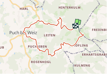
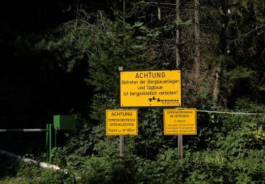
Tocht Te voet van 8,2 km beschikbaar op Stiermarken, Bezirk Weiz, Puch bei Weiz. Deze tocht wordt voorgesteld door SityTrail - itinéraires balisés pédestres.
Beschrijving
Trail created by Apfeldorf Puch bei Weiz.
http://wiki.openstreetmap.org/w/index.php?title=WikiProject_Austria/Wanderwege
Symbol: Weiss-Grün-Weiss 12
Website: http://www.puch-weiz.at/fileadmin/red_gem/Bilder/Inhalte/Tourismus/Wanderkarte_Puch.pdf
Plaatsbepaling
Opmerkingen
Wandeltochten in de omgeving
![Tocht Te voet Stubenberg - Klammrunde - Photo](https://media.geolcdn.com/t/375/260/da81cdef-c26a-4882-b4e5-36b56d66709a.jpeg&format=jpg&maxdim=2)
![Te voet Te voet](https://static1.geolcdn.com/sitytour/trail-icons/100.png)
Te voet
![](/images/other/stat-length.png)
![](https://static1.geolcdn.com/siteimages/upload/files/16400158638029165_repeat_loop_refresh_sync_direction_icon.png)
![Tocht Te voet Stubenberg - Kulmkögerlweg - Photo](https://media.geolcdn.com/t/375/260/c0a498b6-2614-4b7d-bd33-755a963e6bde.jpeg&format=jpg&maxdim=2)
![Te voet Te voet](https://static1.geolcdn.com/sitytour/trail-icons/100.png)
Te voet
![](/images/other/stat-length.png)
![](https://static1.geolcdn.com/siteimages/upload/files/16400158638029165_repeat_loop_refresh_sync_direction_icon.png)
![Tocht Te voet Puch bei Weiz - Tramway - Photo](https://media.geolcdn.com/t/375/260/a3736f39-258b-41cd-b201-43a8776f63c3.jpeg&format=jpg&maxdim=2)
![Te voet Te voet](https://static1.geolcdn.com/sitytour/trail-icons/100.png)
Te voet
![](/images/other/stat-length.png)
![](https://static1.geolcdn.com/siteimages/upload/files/16400158638029165_repeat_loop_refresh_sync_direction_icon.png)
![Tocht Te voet Stubenberg - Zeilrundweg - Photo](https://media.geolcdn.com/t/375/260/ad2859b9-8cfa-4bb8-8292-534fe281ec9d.jpeg&format=jpg&maxdim=2)
![Te voet Te voet](https://static1.geolcdn.com/sitytour/trail-icons/100.png)
Te voet
![](/images/other/stat-length.png)
![](https://static1.geolcdn.com/siteimages/upload/files/16400158638029165_repeat_loop_refresh_sync_direction_icon.png)
![Tocht Te voet Stubenberg - Kreilkogelrunde - Photo](https://media.geolcdn.com/t/375/260/ad2859b9-8cfa-4bb8-8292-534fe281ec9d.jpeg&format=jpg&maxdim=2)
![Te voet Te voet](https://static1.geolcdn.com/sitytour/trail-icons/100.png)
Te voet
![](/images/other/stat-length.png)
![](https://static1.geolcdn.com/siteimages/upload/files/16400158638029165_repeat_loop_refresh_sync_direction_icon.png)
![Tocht Te voet Puch bei Weiz - Ilzbergrunde - Photo](https://media.geolcdn.com/t/375/260/73b3cd53-0e31-4d0c-b653-942b25b8c8f7.jpeg&format=jpg&maxdim=2)
![Te voet Te voet](https://static1.geolcdn.com/sitytour/trail-icons/100.png)
Te voet
![](/images/other/stat-length.png)
![](https://static1.geolcdn.com/siteimages/upload/files/16400158638029165_repeat_loop_refresh_sync_direction_icon.png)
![Tocht Te voet Puch bei Weiz - Wanderweg WH - Photo](https://media.geolcdn.com/t/375/260/cd5fe96f-6ce6-4593-a6d5-2e34f643c899.jpeg&format=jpg&maxdim=2)
![Te voet Te voet](https://static1.geolcdn.com/sitytour/trail-icons/100.png)
Te voet
![](/images/other/stat-length.png)
![](https://static1.geolcdn.com/siteimages/upload/files/16400158638029165_repeat_loop_refresh_sync_direction_icon.png)
![Tocht Te voet Stubenberg - Geierwandweg (23) - Photo](https://media.geolcdn.com/t/375/260/b41cfdee-dd06-4718-bc15-0ae2dc01030c.jpeg&format=jpg&maxdim=2)
![Te voet Te voet](https://static1.geolcdn.com/sitytour/trail-icons/100.png)
Te voet
![](/images/other/stat-length.png)
![](https://static1.geolcdn.com/siteimages/upload/files/16400158638029165_repeat_loop_refresh_sync_direction_icon.png)
![Tocht Te voet Stubenberg - Fieberbründlweg (7) - Photo](https://media.geolcdn.com/t/375/260/ad2859b9-8cfa-4bb8-8292-534fe281ec9d.jpeg&format=jpg&maxdim=2)
![Te voet Te voet](https://static1.geolcdn.com/sitytour/trail-icons/100.png)
Te voet
![](/images/other/stat-length.png)
![](https://static1.geolcdn.com/siteimages/upload/files/16400158638029165_repeat_loop_refresh_sync_direction_icon.png)