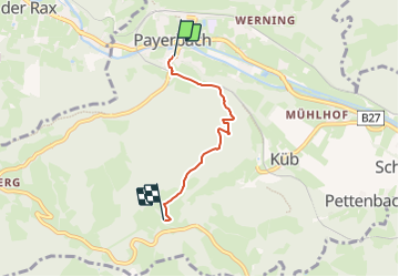
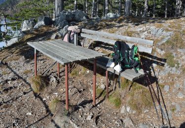
![](/images/other/stat-length.png)
![Tocht Te voet Gemeinde Payerbach - Payerbach - Steinhöfler - Photo](https://media.geolcdn.com/t/1900/400/35bed2ee-e677-4a7b-b649-9bc6d92cee68.jpeg&format=pjpeg&maxdim=2)
Payerbach - Steinhöfler
SityTrail - itinéraires balisés pédestres
Tous les sentiers balisés d’Europe GUIDE+
![Lengte](/images/other/stat-length.png)
![Max. hoogte](https://static1.geolcdn.com/siteimages/upload/files/1508320355ic_sort_altitude_max_24dp.png)
![Positief hoogteverschil](https://static1.geolcdn.com/siteimages/upload/files/1508320355ic_sort_den_pos_24dp.png)
![Km-Effort](/images/other/stat-length.png)
![Min. hoogte](https://static1.geolcdn.com/siteimages/upload/files/1508320355ic_sort_altitude_min_24dp.png)
![Negatief hoogteverschil](https://static1.geolcdn.com/siteimages/upload/files/1508320355ic_sort_den_neg_24dp.png)
![Boucle](https://static1.geolcdn.com/siteimages/upload/files/16400158638029165_repeat_loop_refresh_sync_direction_icon.png)
![Te voet](https://static1.geolcdn.com/sitytour/trail-icons/100.png)
1h27
Moeilijkheid : Gemakkelijk
![Scan deze QR-code om de tocht te openen in de SityTrail-applicatie](https://capi.geolives.com/qq0zvz2zws4bq2lad0pu/sitytour/trails/3129429/qr.png?size=200)
Gratisgps-wandelapplicatie
Over ons
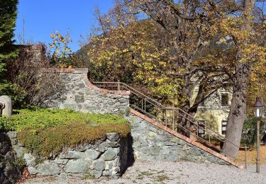
Tocht Te voet van 3,3 km beschikbaar op Neder-Oostenrijk, Bezirk Neunkirchen, Gemeinde Payerbach. Deze tocht wordt voorgesteld door SityTrail - itinéraires balisés pédestres.
Beschrijving
Der ÖTK gilt als Pionier des Fremdenverkehrs. Heute ist der ÖTK mit über 360 Kursen und geführten Touren in 50 Freizeitsportarten der größte Anbieter im Outdoor-Segment in Österreich.
Website: https://www.oetk.at
Plaatsbepaling
Opmerkingen
Wandeltochten in de omgeving
![Tocht Te voet Gemeinde Schottwien - Rundwanderweg - Photo](https://media.geolcdn.com/t/375/260/db4fa6e5-ce96-4cdc-8273-42b6f040655b.jpeg&format=jpg&maxdim=2)
![Te voet Te voet](https://static1.geolcdn.com/sitytour/trail-icons/100.png)
Te voet
![](/images/other/stat-length.png)
![](https://static1.geolcdn.com/siteimages/upload/files/16400158638029165_repeat_loop_refresh_sync_direction_icon.png)
![Tocht Te voet Gemeinde Reichenau an der Rax - Miesleitensteig - Photo](https://media.geolcdn.com/t/375/260/94a78a72-401f-4035-8f29-45b74e3c167e.jpeg&format=jpg&maxdim=2)
![Te voet Te voet](https://static1.geolcdn.com/sitytour/trail-icons/100.png)
Te voet
![](/images/other/stat-length.png)
![](https://static1.geolcdn.com/siteimages/upload/files/16400158638029165_repeat_loop_refresh_sync_direction_icon.png)
![Tocht Te voet Gemeinde Reichenau an der Rax - Weg PA 14 - Photo](https://media.geolcdn.com/t/375/260/94a78a72-401f-4035-8f29-45b74e3c167e.jpeg&format=jpg&maxdim=2)
![Te voet Te voet](https://static1.geolcdn.com/sitytour/trail-icons/100.png)
Te voet
![](/images/other/stat-length.png)
![](https://static1.geolcdn.com/siteimages/upload/files/16400158638029165_repeat_loop_refresh_sync_direction_icon.png)
![Tocht Te voet Gemeinde Gloggnitz - Gloggnitz - Eichberg - Klamm (Kochhof) - Photo](https://media.geolcdn.com/t/375/260/221e4f16-51ee-4c15-be13-40d8b78b893c.jpeg&format=jpg&maxdim=2)
![Te voet Te voet](https://static1.geolcdn.com/sitytour/trail-icons/100.png)
Te voet
![](/images/other/stat-length.png)
![](https://static1.geolcdn.com/siteimages/upload/files/16400158638029165_repeat_loop_refresh_sync_direction_icon.png)
![Tocht Te voet Gemeinde Payerbach - Weg PA 6 - Photo](https://media.geolcdn.com/t/375/260/8a6373ac-1ad9-4169-a7b0-aac7ea3d5304.jpeg&format=jpg&maxdim=2)
![Te voet Te voet](https://static1.geolcdn.com/sitytour/trail-icons/100.png)
Te voet
![](/images/other/stat-length.png)
![](https://static1.geolcdn.com/siteimages/upload/files/16400158638029165_repeat_loop_refresh_sync_direction_icon.png)
![Tocht Te voet Gemeinde Payerbach - Weg PA 12 - Photo](https://media.geolcdn.com/t/375/260/c1868a11-10ce-4e9c-a53a-ef9e5e301b2e.jpeg&format=jpg&maxdim=2)
![Te voet Te voet](https://static1.geolcdn.com/sitytour/trail-icons/100.png)
Te voet
![](/images/other/stat-length.png)
![](https://static1.geolcdn.com/siteimages/upload/files/16400158638029165_repeat_loop_refresh_sync_direction_icon.png)
![Tocht Te voet Gemeinde Payerbach - Weg PA 13 - Photo](https://media.geolcdn.com/t/375/260/1a888f2f-41bc-4976-ab13-98eefca4c601.jpeg&format=jpg&maxdim=2)
![Te voet Te voet](https://static1.geolcdn.com/sitytour/trail-icons/100.png)
Te voet
![](/images/other/stat-length.png)
![](https://static1.geolcdn.com/siteimages/upload/files/16400158638029165_repeat_loop_refresh_sync_direction_icon.png)
![Tocht Te voet Gemeinde Prigglitz - Gahnshauswiese - Obertal - Photo](https://media.geolcdn.com/t/375/260/3043de55-ce89-465c-a227-8b9430716d9f.jpeg&format=jpg&maxdim=2)
![Te voet Te voet](https://static1.geolcdn.com/sitytour/trail-icons/100.png)
Te voet
![](/images/other/stat-length.png)
![](https://static1.geolcdn.com/siteimages/upload/files/16400158638029165_repeat_loop_refresh_sync_direction_icon.png)
![Tocht Te voet Gemeinde Prigglitz - Rote Wand Rundweg - Photo](https://media.geolcdn.com/t/375/260/b6683f38-3588-4711-b885-5e4001427d2d.jpeg&format=jpg&maxdim=2)
![Te voet Te voet](https://static1.geolcdn.com/sitytour/trail-icons/100.png)
Te voet
![](/images/other/stat-length.png)
![](https://static1.geolcdn.com/siteimages/upload/files/16400158638029165_repeat_loop_refresh_sync_direction_icon.png)