![](/images/other/stat-length.png)
![Tocht Te voet Greinbach - Penzendorf Wanderweg 7 - Photo](https://media.geolcdn.com/t/1900/400/b338fd4d-6e8f-49a9-96a7-52c05ab16757.jpeg&format=pjpeg&maxdim=2)
Penzendorf Wanderweg 7
SityTrail - itinéraires balisés pédestres
Tous les sentiers balisés d’Europe GUIDE+
![Lengte](/images/other/stat-length.png)
Lengte
5,1 km
![Max. hoogte](https://static1.geolcdn.com/siteimages/upload/files/1508320355ic_sort_altitude_max_24dp.png)
Max. hoogte
572 m
![Positief hoogteverschil](https://static1.geolcdn.com/siteimages/upload/files/1508320355ic_sort_den_pos_24dp.png)
Positief hoogteverschil
160 m
![Km-Effort](/images/other/stat-length.png)
Km-Effort
7,2 km
![Min. hoogte](https://static1.geolcdn.com/siteimages/upload/files/1508320355ic_sort_altitude_min_24dp.png)
Min. hoogte
422 m
![Negatief hoogteverschil](https://static1.geolcdn.com/siteimages/upload/files/1508320355ic_sort_den_neg_24dp.png)
Negatief hoogteverschil
157 m
![Boucle](https://static1.geolcdn.com/siteimages/upload/files/16400158638029165_repeat_loop_refresh_sync_direction_icon.png)
Boucle
Ja
Markering
Datum van aanmaak :
2022-02-16 16:54:49.531
Laatste wijziging :
2022-03-03 13:53:13.37
![Te voet](https://static1.geolcdn.com/sitytour/trail-icons/100.png)
1h38
Moeilijkheid : Gemakkelijk
![Scan deze QR-code om de tocht te openen in de SityTrail-applicatie](https://capi.geolives.com/qq0zvz2zws4bq2lad0pu/sitytour/trails/3128264/qr.png?size=200)
Gratisgps-wandelapplicatie
Over ons
Tocht Te voet van 5,1 km beschikbaar op Stiermarken, Bezirk Hartberg-Fürstenfeld, Greinbach. Deze tocht wordt voorgesteld door SityTrail - itinéraires balisés pédestres.
Beschrijving
Trail created by Steirische Berg und Naturwacht Orsteinsatzstelle Hartberg.
Symbol: blau-weiss-blau 7
Plaatsbepaling
Land:
Austria
Regio :
Stiermarken
Departement/Provincie :
Bezirk Hartberg-Fürstenfeld
Gemeente :
Greinbach
Locatie:
Unknown
Vertrek:(Dec)
Vertrek:(UTM)
573448 ; 5241260 (33T) N.
Opmerkingen
Wandeltochten in de omgeving
![Tocht Te voet Hartberg Umgebung - Löffelbach - Villa Rustica - Burg Neuberg - Sportplatz Schildbach - Löffenbach (II) - Photo](https://media.geolcdn.com/t/375/260/435820f5-6204-4c3d-a056-0ebf7fea6b43.jpeg&format=jpg&maxdim=2)
![Te voet Te voet](https://static1.geolcdn.com/sitytour/trail-icons/100.png)
Löffelbach - Villa Rustica - Burg Neuberg - Sportplatz Schildbach - Löffenbac...
Te voet
Gemakkelijk
Hartberg Umgebung,
Stiermarken,
Bezirk Hartberg-Fürstenfeld,
Austria
![](/images/other/stat-length.png)
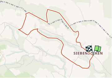
5,8 km | 8,7 km-effort
1h 58min
![](https://static1.geolcdn.com/siteimages/upload/files/16400158638029165_repeat_loop_refresh_sync_direction_icon.png)
Neen
![Tocht Te voet Hartberg Umgebung - Löffelbach - Villa Rustica - Burg Neuberg - Löffenbach (I) - Photo](https://media.geolcdn.com/t/375/260/7662d677-9ccc-4427-a9eb-a8c9a1c8776e.jpeg&format=jpg&maxdim=2)
![Te voet Te voet](https://static1.geolcdn.com/sitytour/trail-icons/100.png)
Löffelbach - Villa Rustica - Burg Neuberg - Löffenbach (I)
Te voet
Gemakkelijk
Hartberg Umgebung,
Stiermarken,
Bezirk Hartberg-Fürstenfeld,
Austria
![](/images/other/stat-length.png)
6,2 km | 9,3 km-effort
2h 6min
![](https://static1.geolcdn.com/siteimages/upload/files/16400158638029165_repeat_loop_refresh_sync_direction_icon.png)
Ja
![Tocht Te voet Hartberg Umgebung - Löffelbach - Häckerberg - Flattendorf-Aue - St. Anna - Löffelbach (IV) - Photo](https://media.geolcdn.com/t/375/260/435820f5-6204-4c3d-a056-0ebf7fea6b43.jpeg&format=jpg&maxdim=2)
![Te voet Te voet](https://static1.geolcdn.com/sitytour/trail-icons/100.png)
Löffelbach - Häckerberg - Flattendorf-Aue - St. Anna - Löffelbach (IV)
Te voet
Gemakkelijk
Hartberg Umgebung,
Stiermarken,
Bezirk Hartberg-Fürstenfeld,
Austria
![](/images/other/stat-length.png)
9,4 km | 13,8 km-effort
3h 8min
![](https://static1.geolcdn.com/siteimages/upload/files/16400158638029165_repeat_loop_refresh_sync_direction_icon.png)
Ja
![Tocht Te voet Sankt Johann in der Haide - St. Johann i.d. Haide - Unterlungitz Rundewanderweg - Photo](https://media.geolcdn.com/t/375/260/11b7653b-2966-47f5-bae3-e1fb34a8f601.jpeg&format=jpg&maxdim=2)
![Te voet Te voet](https://static1.geolcdn.com/sitytour/trail-icons/100.png)
St. Johann i.d. Haide - Unterlungitz Rundewanderweg
Te voet
Gemakkelijk
Sankt Johann in der Haide,
Stiermarken,
Bezirk Hartberg-Fürstenfeld,
Austria
![](/images/other/stat-length.png)
5,4 km | 6,3 km-effort
1h 25min
![](https://static1.geolcdn.com/siteimages/upload/files/16400158638029165_repeat_loop_refresh_sync_direction_icon.png)
Neen
![Tocht Te voet Sankt Johann in der Haide - Fischteich Rundwanderweg - Photo](https://media.geolcdn.com/t/375/260/11b7653b-2966-47f5-bae3-e1fb34a8f601.jpeg&format=jpg&maxdim=2)
![Te voet Te voet](https://static1.geolcdn.com/sitytour/trail-icons/100.png)
Fischteich Rundwanderweg
Te voet
Gemakkelijk
Sankt Johann in der Haide,
Stiermarken,
Bezirk Hartberg-Fürstenfeld,
Austria
![](/images/other/stat-length.png)
8,8 km | 11,5 km-effort
2h 36min
![](https://static1.geolcdn.com/siteimages/upload/files/16400158638029165_repeat_loop_refresh_sync_direction_icon.png)
Ja
![Tocht Te voet Grafendorf bei Hartberg - Stambach Weg 1 - Photo](https://media.geolcdn.com/t/375/260/c62fbda3-1413-4d24-97ed-ac34e183a5b7.jpeg&format=jpg&maxdim=2)
![Te voet Te voet](https://static1.geolcdn.com/sitytour/trail-icons/100.png)
Stambach Weg 1
Te voet
Gemakkelijk
Grafendorf bei Hartberg,
Stiermarken,
Bezirk Hartberg-Fürstenfeld,
Austria
![](/images/other/stat-length.png)
10 km | 16,3 km-effort
3h 41min
![](https://static1.geolcdn.com/siteimages/upload/files/16400158638029165_repeat_loop_refresh_sync_direction_icon.png)
Ja
![Tocht Te voet Grafendorf bei Hartberg - Stambach Weg 4 - Photo](https://media.geolcdn.com/t/375/260/6cd60473-fc2c-43f7-8f1a-26a1b64a16ff.jpeg&format=jpg&maxdim=2)
![Te voet Te voet](https://static1.geolcdn.com/sitytour/trail-icons/100.png)
Stambach Weg 4
Te voet
Gemakkelijk
Grafendorf bei Hartberg,
Stiermarken,
Bezirk Hartberg-Fürstenfeld,
Austria
![](/images/other/stat-length.png)
4,6 km | 7,1 km-effort
1h 37min
![](https://static1.geolcdn.com/siteimages/upload/files/16400158638029165_repeat_loop_refresh_sync_direction_icon.png)
Ja
![Tocht Te voet Grafendorf bei Hartberg - Stambach Weg 14 - Photo](https://media.geolcdn.com/t/375/260/c62fbda3-1413-4d24-97ed-ac34e183a5b7.jpeg&format=jpg&maxdim=2)
![Te voet Te voet](https://static1.geolcdn.com/sitytour/trail-icons/100.png)
Stambach Weg 14
Te voet
Gemakkelijk
Grafendorf bei Hartberg,
Stiermarken,
Bezirk Hartberg-Fürstenfeld,
Austria
![](/images/other/stat-length.png)
4,9 km | 7,6 km-effort
1h 43min
![](https://static1.geolcdn.com/siteimages/upload/files/16400158638029165_repeat_loop_refresh_sync_direction_icon.png)
Ja
![Tocht Te voet Lafnitz - Lafnitz Rundwanderweg L4 - Photo](https://media.geolcdn.com/t/375/260/f31dc91a-406f-4074-b81c-3d7415c4ac80.jpeg&format=jpg&maxdim=2)
![Te voet Te voet](https://static1.geolcdn.com/sitytour/trail-icons/100.png)
Lafnitz Rundwanderweg L4
Te voet
Gemakkelijk
Lafnitz,
Stiermarken,
Bezirk Hartberg-Fürstenfeld,
Austria
![](/images/other/stat-length.png)
7,7 km | 9,6 km-effort
2h 10min
![](https://static1.geolcdn.com/siteimages/upload/files/16400158638029165_repeat_loop_refresh_sync_direction_icon.png)
Ja