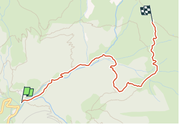
![](/images/other/stat-length.png)
![Tocht Te voet Mezzoldo - Sentiero 111: Mezzoldo (Madonna delle Nevi) - Forcella Rossa - Photo](https://media.geolcdn.com/t/1900/400/b68c7924-ce52-4be5-831c-fdef220ba4d3.jpeg&format=pjpeg&maxdim=2)
Sentiero 111: Mezzoldo (Madonna delle Nevi) - Forcella Rossa
SityTrail - itinéraires balisés pédestres
Tous les sentiers balisés d’Europe GUIDE+
![Lengte](/images/other/stat-length.png)
![Max. hoogte](https://static1.geolcdn.com/siteimages/upload/files/1508320355ic_sort_altitude_max_24dp.png)
![Positief hoogteverschil](https://static1.geolcdn.com/siteimages/upload/files/1508320355ic_sort_den_pos_24dp.png)
![Km-Effort](/images/other/stat-length.png)
![Min. hoogte](https://static1.geolcdn.com/siteimages/upload/files/1508320355ic_sort_altitude_min_24dp.png)
![Negatief hoogteverschil](https://static1.geolcdn.com/siteimages/upload/files/1508320355ic_sort_den_neg_24dp.png)
![Boucle](https://static1.geolcdn.com/siteimages/upload/files/16400158638029165_repeat_loop_refresh_sync_direction_icon.png)
![Te voet](https://static1.geolcdn.com/sitytour/trail-icons/100.png)
2h12
Moeilijkheid : Gemakkelijk
![Scan deze QR-code om de tocht te openen in de SityTrail-applicatie](https://capi.geolives.com/qq0zvz2zws4bq2lad0pu/sitytour/trails/3124925/qr.png?size=200)
Gratisgps-wandelapplicatie
Over ons
Tocht Te voet van 3,7 km beschikbaar op Lombardije, Bergamo, Mezzoldo. Deze tocht wordt voorgesteld door SityTrail - itinéraires balisés pédestres.
Beschrijving
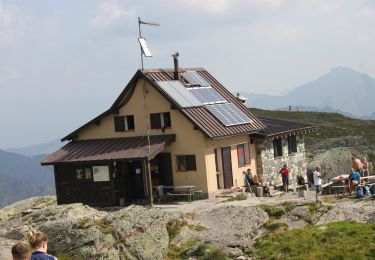
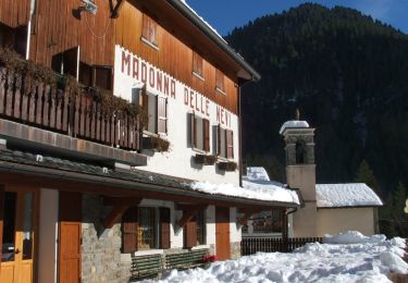
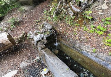
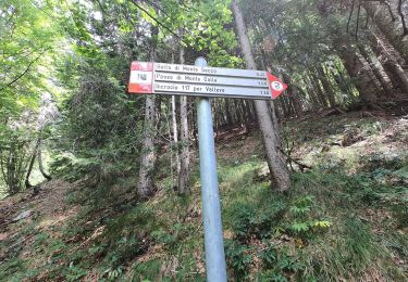
Dal rifugio Madonna delle Nevi (1336 m), sopra Mezzoldo, si risale in prossimità del fiume Brembo in direzione nord-est arrivando alla località Prà del Muto (1488 m). Si abbandona il fondovalle e si sale nel bosco in direzione sud, giungendo poi alla casera Siltri (1730 m) immettendosi così nel sentiero 111A (Sentiero delle Casere) per poi procedere in comune con esso per un
Website: http://geoportale.caibergamo.it/it/sentiero/111
Plaatsbepaling
Opmerkingen
Wandeltochten in de omgeving
![Tocht Te voet Mezzoldo - Sentiero 115: Mezzoldo (Ponte dell'Acqua) - Passo di S. Simone - Photo](https://media.geolcdn.com/t/375/260/b89a21bd-8ca4-4a30-b37a-953d42c6f447.jpeg&format=jpg&maxdim=2)
![Te voet Te voet](https://static1.geolcdn.com/sitytour/trail-icons/100.png)
Te voet
![](/images/other/stat-length.png)
![](https://static1.geolcdn.com/siteimages/upload/files/16400158638029165_repeat_loop_refresh_sync_direction_icon.png)
![Tocht Te voet Averara - Sentiero 113: Mezzoldo (Soliva) - Ca' San Marco - Photo](https://media.geolcdn.com/t/375/260/b115d387-71a6-4154-8ca8-a048f966bffa.jpeg&format=jpg&maxdim=2)
![Te voet Te voet](https://static1.geolcdn.com/sitytour/trail-icons/100.png)
Te voet
![](/images/other/stat-length.png)
![](https://static1.geolcdn.com/siteimages/upload/files/16400158638029165_repeat_loop_refresh_sync_direction_icon.png)
![Tocht Te voet Averara - IT-161 - Photo](https://media.geolcdn.com/t/375/260/766ea1b4-e990-4dd2-be13-c0404ff52356.jpeg&format=jpg&maxdim=2)
![Te voet Te voet](https://static1.geolcdn.com/sitytour/trail-icons/100.png)
Te voet
![](/images/other/stat-length.png)
![](https://static1.geolcdn.com/siteimages/upload/files/16400158638029165_repeat_loop_refresh_sync_direction_icon.png)
![Tocht Te voet Valleve - IT-201 - Photo](https://media.geolcdn.com/t/375/260/3181807b-d7d9-4afb-9c20-cd7a3c0ad38d.jpeg&format=jpg&maxdim=2)
![Te voet Te voet](https://static1.geolcdn.com/sitytour/trail-icons/100.png)
![Tocht Te voet Mezzoldo - Sentiero 124: Rifugio Madonna delle Nevi - Bivacco Zamboni - Photo](https://media.geolcdn.com/t/375/260/697c64b8-be05-43a3-96cc-dad10aa82c2a.jpeg&format=jpg&maxdim=2)
![Te voet Te voet](https://static1.geolcdn.com/sitytour/trail-icons/100.png)
Te voet
![](/images/other/stat-length.png)
![](https://static1.geolcdn.com/siteimages/upload/files/16400158638029165_repeat_loop_refresh_sync_direction_icon.png)
![Tocht Te voet Mezzoldo - (SI D17S) Rifugio Balicco - Rifugio Dordona - Photo](https://media.geolcdn.com/t/375/260/5895fabb-8256-4cb3-906a-f85bf70bcd24.jpeg&format=jpg&maxdim=2)
![Te voet Te voet](https://static1.geolcdn.com/sitytour/trail-icons/100.png)
Te voet
![](/images/other/stat-length.png)
![](https://static1.geolcdn.com/siteimages/upload/files/16400158638029165_repeat_loop_refresh_sync_direction_icon.png)
![Tocht Te voet Averara - Sentiero delle Orobie Occidentali - Tappa 4 - Photo](https://media.geolcdn.com/t/375/260/3181807b-d7d9-4afb-9c20-cd7a3c0ad38d.jpeg&format=jpg&maxdim=2)
![Te voet Te voet](https://static1.geolcdn.com/sitytour/trail-icons/100.png)
Te voet
![](/images/other/stat-length.png)
![](https://static1.geolcdn.com/siteimages/upload/files/16400158638029165_repeat_loop_refresh_sync_direction_icon.png)
![Tocht Te voet Piazzatorre - Sentiero 121: Piazzatorre (Piazzo) - Torcola Vaga (sentiero 119) - Photo](https://media.geolcdn.com/t/375/260/2306d556-fc4b-4492-9e6b-0c013ab2cfbe.jpeg&format=jpg&maxdim=2)
![Te voet Te voet](https://static1.geolcdn.com/sitytour/trail-icons/100.png)
Te voet
![](/images/other/stat-length.png)
![](https://static1.geolcdn.com/siteimages/upload/files/16400158638029165_repeat_loop_refresh_sync_direction_icon.png)
![Tocht Te voet Piazzatorre - Sentiero 118: Piazzatorre (Piazzo) - Passo e Casera di Monte Colle - Photo](https://media.geolcdn.com/t/375/260/fa2544f6-6b19-4970-a232-2a26d7de4199.jpeg&format=jpg&maxdim=2)
![Te voet Te voet](https://static1.geolcdn.com/sitytour/trail-icons/100.png)
Te voet
![](/images/other/stat-length.png)
![](https://static1.geolcdn.com/siteimages/upload/files/16400158638029165_repeat_loop_refresh_sync_direction_icon.png)